MyTopo
Terre Hill Pennsylvania US Topo Map
Couldn't load pickup availability
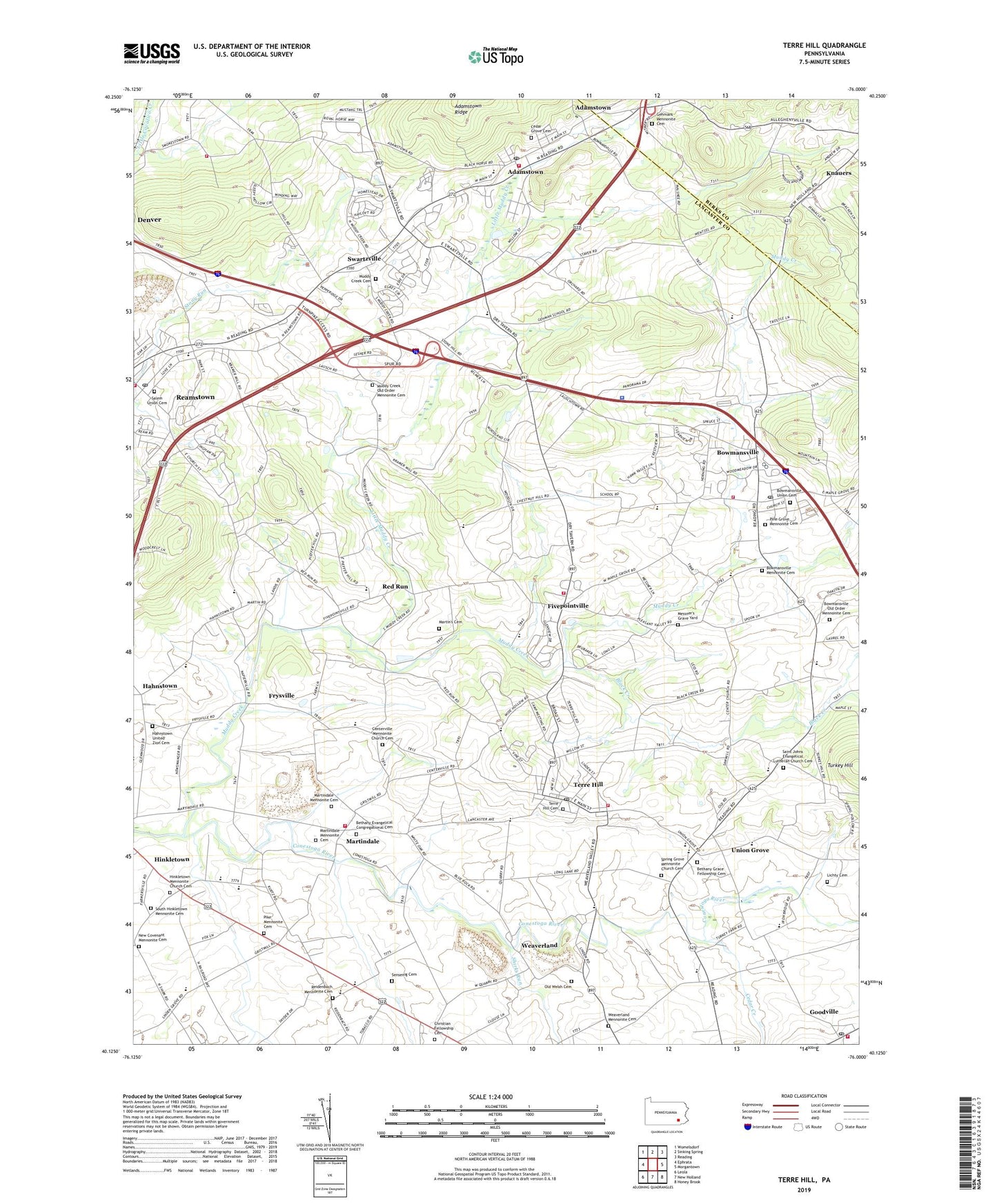
2019 topographic map quadrangle Terre Hill in the state of Pennsylvania. Scale: 1:24000. Based on the newly updated USGS 7.5' US Topo map series, this map is in the following counties: Lancaster, Berks. The map contains contour data, water features, and other items you are used to seeing on USGS maps, but also has updated roads and other features. This is the next generation of topographic maps. Printed on high-quality waterproof paper with UV fade-resistant inks.
Quads adjacent to this one:
West: Ephrata
Northwest: Womelsdorf
North: Sinking Spring
Northeast: Reading
East: Morgantown
Southeast: Honey Brook
South: New Holland
Southwest: Leola
Contains the following named places: Adamstown, Adamstown Fire Company 1 Station 11, Adamstown Post Office, Almar - Vu Farm, Bethany Evangelical Congregational Cemetery, Bethany Grace Fellowship Cemetery, Bible Conference Church, Black Creek, Blue Ball Quarry, Blue Rock Farm, Borough of Adamstown, Borough of Terre Hill, Bowmansville, Bowmansville Census Designated Place, Bowmansville Church, Bowmansville Fire Company Station 33, Bowmansville Mennonite Cemetery, Bowmansville Old Order Mennonite Cemetery, Bowmansville Post Office, Bowmansville Union Cemetery, Brecknock School, Brubaker Park, Burkholder Quarry, Cedar Creek, Cedar Grove Cemetery, Center School, Centerville Mennonite Church Cemetery, Chestnut School, Christ Chapel, Christian Fellowship Cemetery, Cocalico High School, Conestoga School, Cross Roads School, Earl Union School, East Cocalico Township Police Department, Evergreen Farm, Fairville Post Office, Fifth Day Farm, Fivepointville, Fivepointville Ambulance Station 36, Fivepointville Census Designated Place, Fivepointville Fire Company Station 32, Frysville, Frysville Farm, Gehmans Church, Gehmans Mennonite Cemetery, Gehmans School, Goodville, Goodville Census Designated Place, Goodville Post Office, Grace Chapel, Hahnstown, Hahnstown United Zion Cemetery, Hawk Valley Public Golf Course, Hinkletown, Hinkletown Mennonite Church Cemetery, Hoover Farm, Kurtz Quarry, Lichty Cemetery, Lincoln Independence School, Linden Grove School, Little Muddy Creek, Martindale, Martindale Mennonite Cemetery, Martindale Volunteer Fire Company Station 3, Martin's Cemetery, Memorial Park, Messner's Grave Yard, Muddy Creek, Muddy Creek Cemetery, Muddy Creek Church, Muddy Creek Old Order Mennonite Cemetery, Muddy Creek Post Office, Napiersville, Napierville School, New Covenant Mennonite Cemetery, Old Welsh Cemetery, Pennsylvania State Police Troop T Bowmansville Station, Pike Mennonite Cemetery, Pine Grove Mennonite Cemetery, Reamstown, Reamstown Census Designated Place, Reamstown Fire Company 1 Station 17 - 1, Reamstown Post Office, Red Run, Red Run Church, Reidenbach, Reidenbach Church, Reidenbach Mennonite Cemetery, Rock Run, Saint Johns Chapel, Saint Johns Church, Saint Johns Evangelical Lutheran Church Cemetery, Salem Union Cemetery, Sand Hill Farms, Sensenig, Sensenig Cemetery, Shirks Run, Smokestown Fire Company Station 17 - 2, South Hinkletown Mennonite Cemetery, Spring Grove Mennonite Church Cemetery, Springleaf Farm, Stauffer's Fruit Farm, Swartzville, Swartzville Census Designated Place, Swartzville Post Office, Terre Hill, Terre Hill Cemetery, Terre Hill Post Office, Township of Brecknock, Township of East Cocalico, Turkey Hill, Union Grove, Union Zion Church, Weaver Homestead Farm, Weaverland, Weaverland Mennonite Cemetery, Weaverland Quarry, Weaverland School, Weaverland Valley Fire Department Main Station 30, Weaverland Valley Fire Department Station 30 - South Station, Weavers Mill Post Office, Wenger School, West Terre Hill School, White Oak School, Wide Hollow School, ZIP Codes: 17507, 17519, 17581, 19501