MyTopo
Crompton Rhode Island US Topo Map
Couldn't load pickup availability
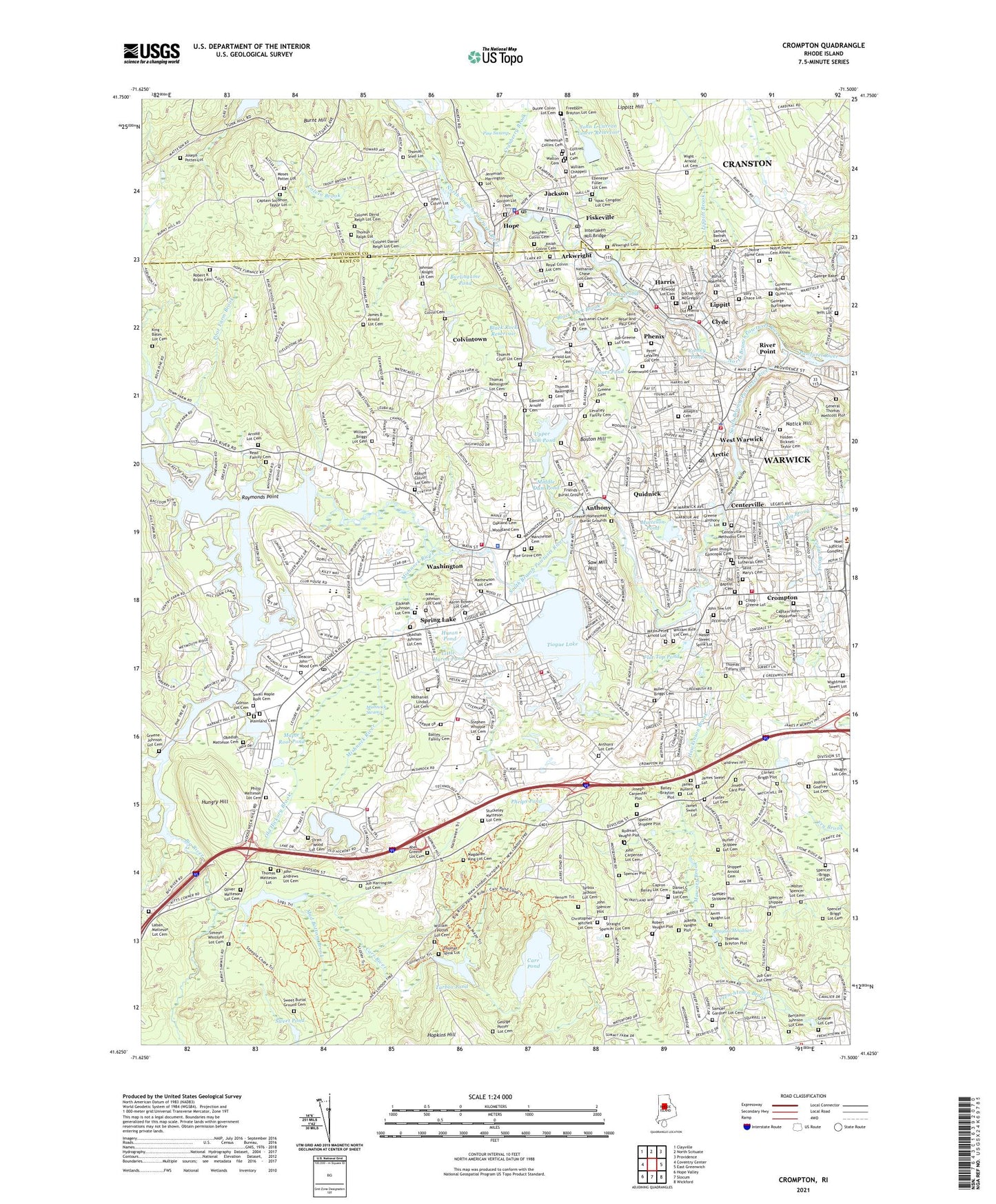
2021 topographic map quadrangle Crompton in the state of Rhode Island. Scale: 1:24000. Based on the newly updated USGS 7.5' US Topo map series, this map is in the following counties: Kent, Providence. The map contains contour data, water features, and other items you are used to seeing on USGS maps, but also has updated roads and other features. This is the next generation of topographic maps. Printed on high-quality waterproof paper with UV fade-resistant inks.
Quads adjacent to this one:
West: Coventry Center
Northwest: Clayville
North: North Scituate
Northeast: Providence
East: East Greenwich
Southeast: Wickford
South: Slocum
Southwest: Hope Valley
Contains the following named places: Abbott - Colvin Lot Cemetery, Andrews Hill, Anthony, Anthony Lot Cemetery, Arctic, Arctic Dam, Arkwright, Arnold - Stone Lot Cemetery, Asa Arnold Lot Cemetery, Bailey - Brayton Plot, Balm of Gilead Corner, Battey Family Cemetery, Bear Brook, Benjamin Johnson Lot Cemetery, Big River, Birch Hill, Black Rock Brook, Black Rock Reservoir, Black Rock Reservoir Dam, Boston Hill, Brayton Meadows, Burlingame Brook, Burlingame Pond, Burnt Hill, Camp Bosco, Capron - Bailey Lot Cemetery, Captain John Waterman Lot, Captain Solomon Taylor Lot, Capwell Mill Pond, Cards Saw Mill, Carr Pond, Carr Pond Dam, Carr River, Cedar Brook, Centerville, Centerville Methodist Cemetery, Centerville Pond Dam, Clapp - Greene Lot, Clarke Brook, Clyde, Colonel Daniel Relph Lot Cemetery, Colvin Brook, Colvin Cemetery, Colvintown, Conley Pond, Cornell - Briggs Plot, Cottrell Lot Cemetery, Coventry Airpark, Cowessett Corners Shopping Center, Cranberry Brook, Cranston Country Club, Crompton, Crompton Lower Dam, Daniel C Bailey Lot Cemetery, Deacon John Wood Cemetery, Doctor John McGregor Lot, Dutee Colvin Lot Cemetery, East Greenwich Golf Course, Edmund Arnold Cemetery, Elkanah Johnson Lot Cemetery, Emanual Lutheran Cemetery, Fiskeville, Flat River Reservoir, Flat River Reservoir Dam, Flat Top Pond, Fones Pond, Foster Lot Cemetery, Friends Burial Ground, General Nathaniel Green Homestead, General Thomas Wescott Lot, General Thomas Westcott Plot, George Baker Lot, George Burlingame Lot, Gorton Lot Cemetery, Governor Robert Quinn Lot, Greene - Anthony Lot, Greene - Johnson Lot Cemetery, Greene Lot Cemetery, Greenwood Cemetery, Harris, Hawkinson Brook, Hazard Brothers Orchard, Hazards Indian Rock Orchard, Holden - Bicknell - Taylor Cemetery, Hope, Hope Dam, Hungry Hill, Huron Pond, Ike Shippee Corner, Isaac Johnson Lot Cemetery, J L Curran Park, Jackson, James B Arnold Lot Cemetery, James Sweet Lot, Jeremiah Harrington Lot, Joanna Vaughn Plot, Job Greene Cemetery, Job Greene Lot Cemetery, John Andrews Lot Cemetery, John Colvin Lot, John L Curran Lower Reservoir, John Spencer Plot, John Tew Lot, Johnson - Knight Lot Cemetery, Joseph Card Plot, Joseph Carpenter Plot, Joseph Potter Lot, Josiah Colvin Cemetery, Kent County, King - Bates Lot Cemetery, Kitts Corner, Laban Matteson Lot Cemetery, Lake Mishnock, Lippitt, Lippitt Brook, Lippitt Hill, Lippitt Mill, Little Huron Pond, Lory Chace Lot, Lucy Tefft Lot, Major Peleg Arnold Lot, Manchester Cemetery, Maple Root Cemetery, Maple Root Pond, Mathewson Lot Cemetery, Matteson Pond, Mawney Brook, Middle Dam Pond, Midville Country Club, Mill Pond Dam, Miller Briggs Cemetery, Mishnock River, Mishnock Swamp, Moosehorn Corner, Moses Potter Lot, Mud Bottom Brook, Nason - Sweet - Spink Lot, Nathaniel Chace Lot Cemetery, Nathaniel Chase Lot Cemetery, Nathaniel Lindall Lot Cemetery, Natick Hill, Natick Pond, Nehemiah Collins Cemetery, North Branch Pawtuxet River, Notre Dame Cemetery, Notre Dame Cemetery Annex, Oakland Cemetery, Obadiah Johnson Lot Cemetery, Old Baptist Cemetery, Old Hickory Brook, Old Phenix Cemetery, Oliver Matteson Lot Cemetery, Olney B Pierce Lot, Pawtuxet River, Pawtuxet River-South Branch, Pearce Pond, Peter LeValley Lot Cemetery, Phelps Pond, Phenix, Pine Grove Cemetery, Pine Swamp, Plainland Cemetery, Poor Farm Brook, Quidnick, Raymonds Point, Read Family Cemetery, Reynolds Pond, River Point, Robert K Brant Cemetery, Robert Vaughn Plot, Rocky Hill Fairgrounds, Rodman Vaughn Plot, Royal Colvin Lot Cemetery, Rufus Wakefield Lot, Saint Joseph's Cemetery, Saint Mary's Cemetery, Saint Marys Crompton Rectory Cemetery, Saint Peter and Paul Cemetery, Saint Philips Episcopal Cemetery, Samuel Gardner Lot Cemetery, Samuel Shippee Plot, Saw Mill Hill, Shippee - Arnold Cemetery, Shippee Corner, Shippees Mill, Simeon Whitford Lot Cemetery, Small Maple Root Cemetery, Snell - Atwood Lot Cemetery, South Branch Pawtuxet River, Spencer - Briggs Lot Cemetery, Spencer - Shippee Plot, Spencer Mill, Spencer Plot, Spencer Shippee Plot, Spencers Corner, Spring Lake, Stephen Whipple Lot Cemetery, Strait - Wood Lot Cemetery, Stuckeley Matteson Lot Cemetery, Sweet - Blanchard Lot, Sweet Burial Ground Cemetery, Sweet Pond, Tarbox Corner, Tarbox Pond, Tarbox Pond Dam, Thomas Brayton Plot, Thomas Matteson Lot, Thomas Ralph Lot, Thomas Remington Cemetery, Thomas Remington Lot Cemetery, Thomas Snell Lot, Thomas Tiffany Lot, Tillinghast Cotton Mill Twine Factory, Tiogue Lake, Tiogue Lake Dam, Town of East Greenwich, Town of West Warwick, Upper Dam Pond, Upper Dam Pond Dam, Valley Country Club on Ledgemont, Valley Queen Mill, Walter Spencer Lot Cemetery, Walton Cemetery, Washington, Washington Pond Upper Dam, West Warwick, West Warwick Census Designated Place, West Warwick Country Club, Wightman - Sweet Lot, William Briggs Lot Cemetery, William Chappell Lot, William J Potter Lot Cemetery, Woodland Cemetery, ZIP Codes: 02816, 02893