MyTopo
Prudence Island Rhode Island US Topo Map
Couldn't load pickup availability
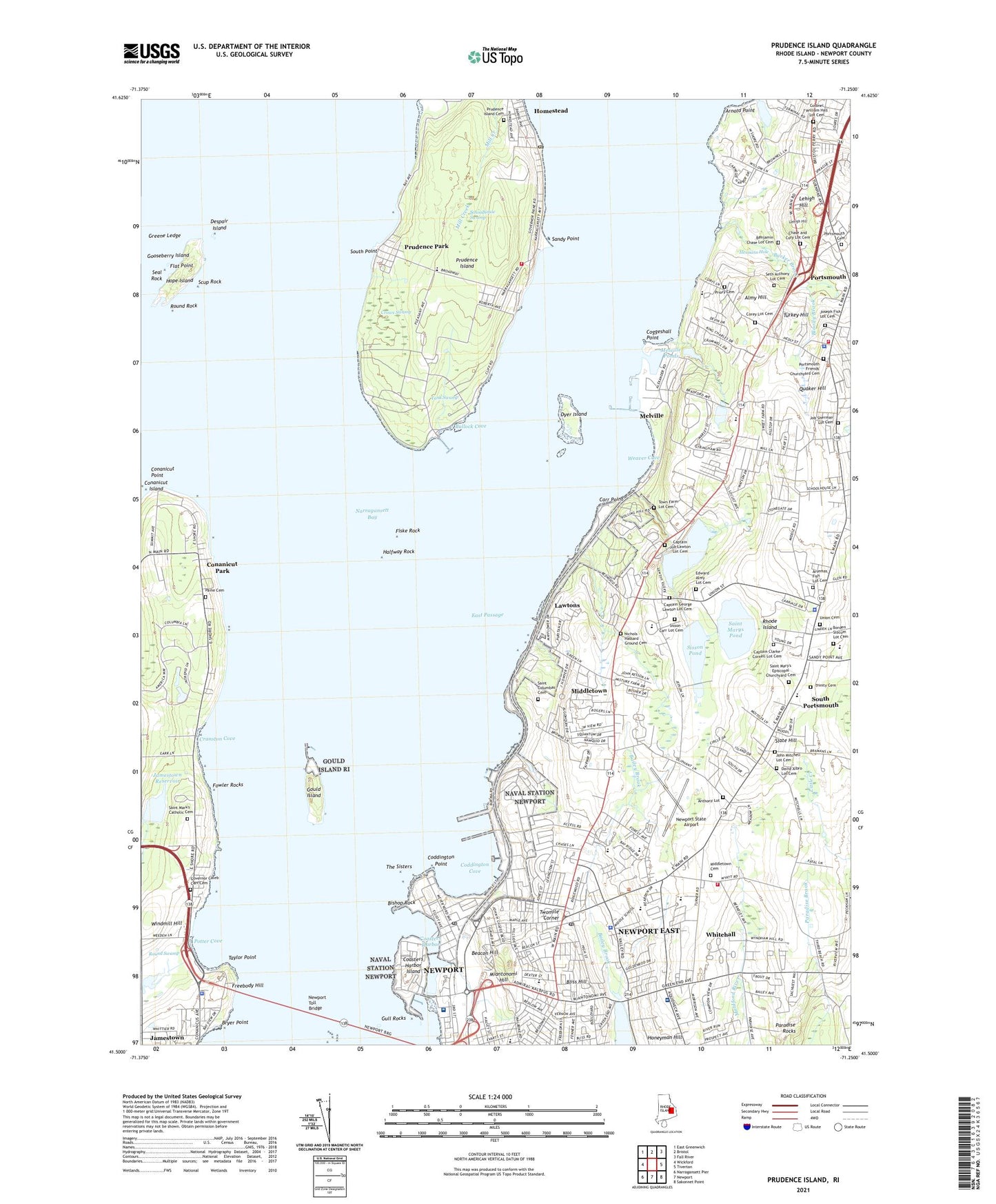
2021 topographic map quadrangle Prudence Island in the state of Rhode Island. Scale: 1:24000. Based on the newly updated USGS 7.5' US Topo map series, this map is in the following counties: Newport. The map contains contour data, water features, and other items you are used to seeing on USGS maps, but also has updated roads and other features. This is the next generation of topographic maps. Printed on high-quality waterproof paper with UV fade-resistant inks.
Quads adjacent to this one:
West: Wickford
Northwest: East Greenwich
North: Bristol
Northeast: Fall River
East: Tiverton
Southeast: Sakonnet Point
South: Newport
Southwest: Narragansett Pier
Contains the following named places: Almy Hill, Ames Plaza Shopping Center, Aquidneck Shopping Centre, Arnold Point, Artemas Fish Lot Cemetery, Bailey Brook, Barker Brook, Bay Island Park, Bay Island Park South Prudence Island, Beacon Hill, Beginnings the Childrens School, Benjamin Chase Lot Cemetery, Berkeley School, Birds Nest, Bishop Rock, Bliss Hill, Bloody Brook, Borden Slocum Lot Cemetery, Brickhouse Swamp, Bright Ideas Child Care Center, Browns Lane Plaza Shopping Center, Bryer Point, Bullock Cove, Butterfly Zoo, Butts Hill, Captain Clarke Cornell Lot Cemetery, Captain George Lawton Lot Cemetery, Captain Job Lawton Lot Cemetery, Carr Point, Chase and Cory Lot Cemetery, Coasters Harbor, Coasters Harbor Island, Coddington Cove, Coddington Point, Coggeshall Point, Coggeshall School, Colonel William Hall Lot Cemetery, Conanicut Island Light, Conanicut Park, Conanicut Point, Corey Lane, Corey Lot Cemetery, Cottrell Field, Countryside Childrens Center, Cranston Cove, Crows Swamp, David Albro Lot Cemetery, Despair Island, Doctor M H Sullivan School, Dyer Island, East Passage, East Passage Yachting Center, Eastgate Shopping Center, Edward Almy Lot Cemetery, Escobar Highland Farm, Fiske Rock, Flat Point, Forest Avenue Elementary School, Forest Avenue School, Fort Butts, Fowler Rocks, Freebody Hill, George H Triplett School, Gooseberry Island, Gould Island, Gould Island Light, Governor Caleb Carr Cemetery, Green Animals Topiary Garden, Green End Fort, Green Valley Golf Course, Greene Ledge, Growing Children of Rhode Island Day Care Center, Gull Rocks, Gull Rocks Light, Halfway Rock, Hessians Hole, Homestead, Honeyman Hill, Hope Island, Howland School, Hutchinson School, James L Maher School, Jamestown Golf Course, Jamestown Police Department, Jamestown Reservoir, Jamestown Reservoir Dam, Jamestown Windmill, Jamestown-Newport Ferry, Job Sherman Lot Cemetery, John F Kennedy Elementary School, John F Kennedy School, John Mitchell Lot Cemetery, Joseph Fish Lot Cemetery, Joseph H Gaudet Middle School, Joshua Anthony Lot Cemetery, Lawton Valley, Lawton Valley Reservoir, Lawton Valley Reservoir Dam, Lawtons, Lehigh Hill, Little Friends Day Care Center, Luce Hall, Mall at Newport, Marsh Meadows Wildlife Preserve, Melville, Melville Census Designated Place, Melville Elementary School, Melville Ponds, Melville Ponds Campground, Memorial Park, Memorial to Black Soldiers, Miantonomi Hill, Middletown, Middletown Fire Department, Middletown Four Corners Cemetery, Middletown High School, Middletown Historical Society Building, Middletown Plaza Shopping Center, Middletown Police Department, Middletown Post Office, Middletown Public Library, Middletown Town Hall, Mill Creek, Mount Hope Maritime Terminal, Narragansett Bay, Naval Health Clinic New England, Naval Hospital Medical Library, Naval Station Newport, Naval Station Newport Fire Department, Naval Training Station Newport, Naval War College Museum, NETC Station Post Office, Newport Airport, Newport Butterfly Farm, Newport County Catholic Regional School, Newport County Chamber of Commerce, Newport East Census Designated Place, Newport Memorial Tower, Newport Naval Air Facility, Newport State Airport, Newport Toll Bridge, Newport Vineyards and Winery, Nichols - Hassard Ground Cemetery, Old Schoolhouse, Oliphant School, One Mile Corner, Paine Cemetery, Paradise Mobile Home Park, Paradise Rocks, Paradise School, Paradise Valley Park, Portsmouth, Portsmouth Abbey School, Portsmouth Abbey School Library, Portsmouth Barracks, Portsmouth Cemetery, Portsmouth Fire Department, Portsmouth Friends' Churchyard Cemetery, Portsmouth High School, Portsmouth Historical Society Building, Portsmouth Middle School, Portsmouth Nursery School, Portsmouth Police Department, Portsmouth Station, Portsmouth Town Hall, Potter Cove, Prescott Middle School, Priory Cemetery, Priory School, Prudence Island, Prudence Island Cemetery, Prudence Island Lighthouse, Prudence Island Post Office, Prudence Island Volunteer Fire Department, Prudence Park, Prudence School, Quaker Hill, Rhode Island, Rhode Island State Police Portsmouth Barracks, Round Rock, Round Swamp, Sachuest Golf Club, Saint Columbas Cemetery, Saint Mark's Catholic Cemetery, Saint Mary's Episcopal Churchyard Cemetery, Saint Marys Pond, Saint Marys Pond Dam, Saint Philomena School, Sandy Point, Schoolhouse Swamp, Scup Rock, Seal Rock, Seth Anthony Lot Cemetery, Sheffield School, Shining Star Preschool, Shreeves Creek, Sisson - Carr Lot Cemetery, Sisson Pond, Sisson Pond Dam, Slate Hill, South Point, South Portsmouth, Southernmost Schoolhouse, Sweet Berry Farm, Tank Swamp, Taylor Point, Ted Hood Marine Complex, Temple Shalom Judaica Library, The Pennefield School, The Sisters, Town Farm Lot Cemetery, Town of Jamestown, Town of Middletown, Town of Portsmouth, Trinity Cemetery, Turkey Hill, Twomile Corner, Union Cemetery, United State Naval War College Library, United States Naval War College, United States Navay Pier 2, United States Navy Pier 1, WADK-AM (Newport), Wanumetonomy Golf Club, Weaver Cove, Whitehall, Whitehall Museum, Windmill Hill, Windmill Hill Historic District, Witherbee School, WJHD-FM (Portsmouth), ZIP Codes: 02841, 02842, 02871, 02872