MyTopo
Blacksburg South South Carolina US Topo Map
Couldn't load pickup availability
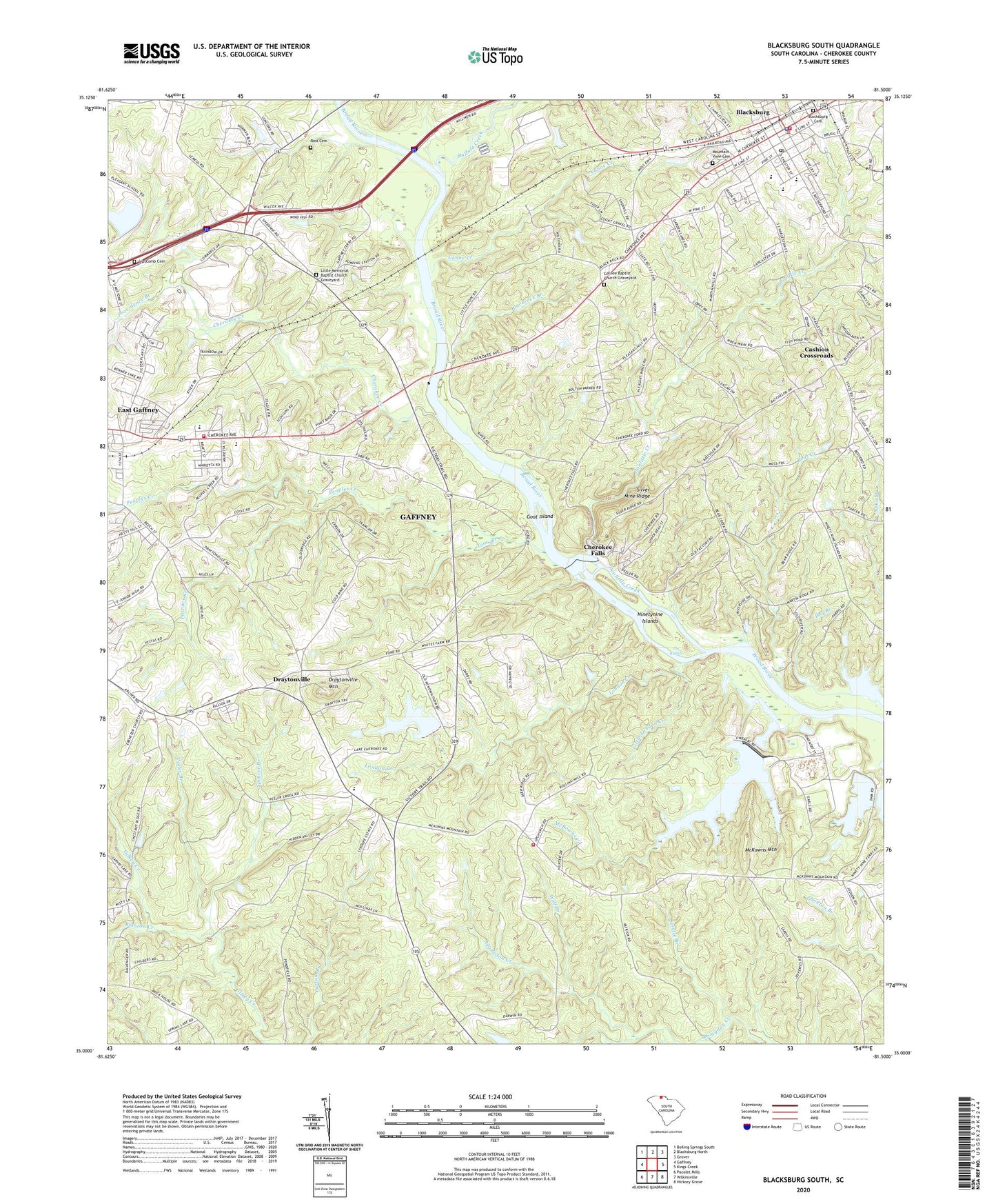
2020 topographic map quadrangle Blacksburg South in the state of South Carolina. Scale: 1:24000. Based on the newly updated USGS 7.5' US Topo map series, this map is in the following counties: Cherokee. The map contains contour data, water features, and other items you are used to seeing on USGS maps, but also has updated roads and other features. This is the next generation of topographic maps. Printed on high-quality waterproof paper with UV fade-resistant inks.
Quads adjacent to this one:
West: Gaffney
Northwest: Boiling Springs South
Northeast: Grover
East: Kings Creek
Southeast: Hickory Grove
South: Wilkinsville
Southwest: Pacolet Mills
Contains the following named places: Alberts Chapel African Methodist Episcopal Church, Alma Elementary School, Bear Creek, Bethel Christian Methodist Episcopal Church, Blackrock Branch, Blacksburg, Blacksburg Associate Reformed Presbyterian Church, Blacksburg Branch Library, Blacksburg Cemetery, Blacksburg Elementary School, Blacksburg High School, Blacksburg Police Department, Blacksburg Post Office, Blacksburg Presbyterian Church, Blacksburg Volunteer Fire Department, Blanton Creek, Briar Creek, Buffalo Creek, Calvary Baptist Church, Canoe Creek, Cashion Crossroads, Casnoe School, Cherokee Area Vocational School, Cherokee County, Cherokee Creek, Cherokee Falls, Cherokee Falls Census Designated Place, Cherokee Ferry, Cherokee Ford Recreation Area, Cherokee Progressive School, Cherokee Speedway, Church of God, Crestmont, DMW Volunteer Fire Department, Doolittle Creek, Draytonville, Draytonville Baptist Church, Draytonville Baptist Church Graveyard, Draytonville Elementary School, Draytonville Mountain, Draytonville School, East Gaffney Baptist Church, East Gaffney Census Designated Place, Easterly Heights, Ebenezer Baptist Church, Ebenezer School, Faith Baptist Church, First Baptist Church, Furnace Creek, Gaffney City Fire Department East Gaffney, Gaffney Division, Galilee Baptist Church Graveyard, Galilee School, Glenhaven, Glenwood Estates, Goat Island, Golden Springs School, Heritage Christian School, Hillbrook, Hopewell Baptist Church Graveyard, Hopewell Church, Ingram Presbyterian Church, Lake Cherokee, Lake Whelchel, Laurelwood, Lawn, Lipscomb Cemetery, Little London Creek, Little Memorial Baptist Church, Little Memorial Baptist Church Graveyard, London Creek, Maplewood, Masons Store, Massadonia Baptist Church, McGowen School, McKowns Creek, McKowns Mountain, McKowns Mountain Church, Meadow Creek Industrial Center, Mercer, Moss Family Cemetery, Mount Ararat Church, Mountain View Cemetery, New Hope Baptist Church, Ninetynine Islands, Peeler Branch, Peoples Creek, Piney Grove Church, Pleasant Hill Baptist Church Graveyard, Pleasant Hill Church, Providence Branch, Robinson Church, Ross Cemetery, Saint John Methodist Church, Sardis Church, Service Branch, Silver Mine Ridge, South Carolina Noname 11001 Dam, South Carolina Noname 11017 D-3401 Dam, South Carolina Noname 11022 D-3417 Dam, South Carolina Noname 11026 D-3418 Dam, South Carolina Noname 16028 D-3725 Dam, Spencer Branch, The Rapids, Toms Branch, Town of Blacksburg, Trinity African Methodist Episcopal Zion Church, Union Church, Wolf Branch