MyTopo
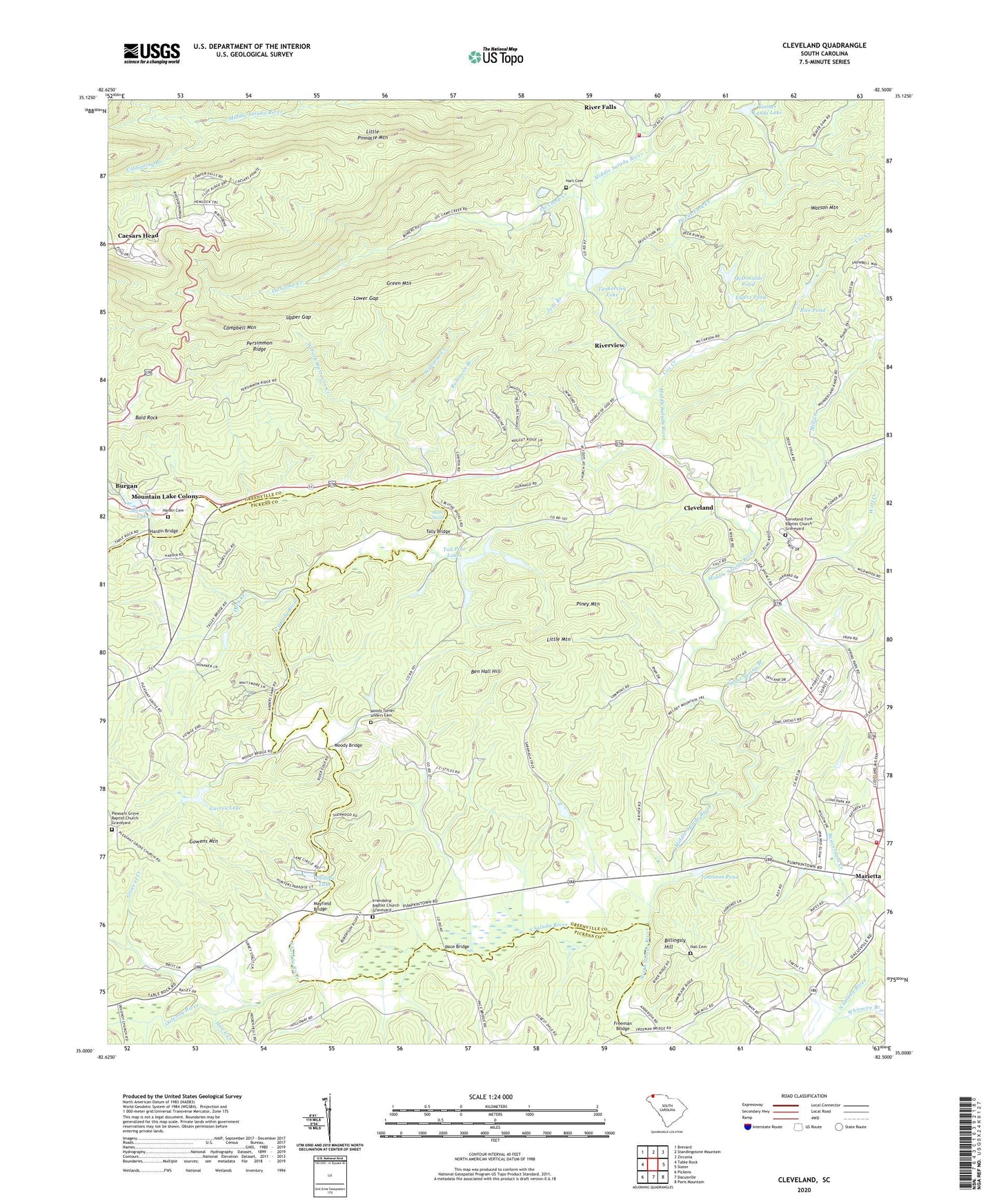
Cleveland South Carolina US Topo Map
Couldn't load pickup availability
2020 topographic map quadrangle Cleveland in the state of South Carolina. Scale: 1:24000. Based on the newly updated USGS 7.5' US Topo map series, this map is in the following counties: Greenville, Pickens. The map contains contour data, water features, and other items you are used to seeing on USGS maps, but also has updated roads and other features. This is the next generation of topographic maps. Printed on high-quality waterproof paper with UV fade-resistant inks.
Quads adjacent to this one:
West: Table Rock
Northwest: Brevard
Northeast: Zirconia
East: Slater
Southeast: Paris Mountain
South: Dacusville
Southwest: Pickens
Contains the following named places: Allison School, Bald Rock, Beaverdam Creek, Ben Hall Hill, Billingsly Hill, Blythe Shoals, Caesars Head, Caesars Head Census Designated Place, Caesars Head Post Office, Caesars Head State Park, Camp Harris Pond Dam D-2832, Camp Marietta, Camp Parker, Camp Stanley Harris, Campbell Mountain, Civitan Camp, Cleveland, Cleveland First Baptist Church Graveyard, Cleveland Lookout Tower, Coldspring Branch, Cox Camp Creek, Cox Creek, Devils Fork Creek, Duck Creek, Ehlers Pond, Ehlers Pond Dam, Ehlers Pond Dam D-1111, F Bergman Pond Dam D-1106, Falls Creek, Freeman Bridge, Friendship Baptist Church Graveyard, Friendship Church, Gap Creek, Garren Lake, Garren Lake Dam D-2916, Gowens Creek, Gowens Mountain, Green Mountain, Grissom Branch, Hall Cemetery, Hardin Bridge, Hardin Cemetery, Hart Cemetery, Hawk Creek, Holiday Lake Dam D-2207, Holly Pot Lake Dam D-2827, Jane Branch, Little Mountain, Little Pinnacle Mountain, Lower Gap, Marietta, Mayfield, Mayfield Bridge, McDonalds Pond, Middle River Church, Middle River School, Middle Saluda River, Mill Creek, Moody Bridge, Moody Turner Anders Cemetery, Mountain Lake, Mountain Lake Colony, Oil Camp Creek, Olga, Oolenoy River, Pace Bridge, Persimmon Ridge, Phillips Lake, Piney Mountain, Pleasant Grove Baptist Church, Pleasant Grove Baptist Church Graveyard, Pleasant Grove School, Rice Pond, Rice Pond Dam D-2831, River Falls, River Falls Fire Department Headquarters, Riverview, Robinson Branch, Slater Marietta Fire Department, Slater-Marietta Division, South Carolina Noname 23020 D-1095 Dam, South Carolina Noname 23027 D-2830 Dam, South Saluda Church, Spout Spring Branch, Tall Pine Lakes, Talleys Mill, Tally Bridge, Tankersley Lake, Tankersley Lake Dam, Timber Lands Lake, Timber Lands Lake Dam D-2829, Timmons Pond, Timmons Pond Dam D-2833, Upper Gap, Wabac Pond Dam D-3296, Watson Mountain, Wattacoo, Wattacoo Creek, West Fork Wattacoo Creek, WFBC-FM (Greenville), Wolf Creek, WYFF-TV (Greenville)