MyTopo
Cowpens South Carolina US Topo Map
Couldn't load pickup availability
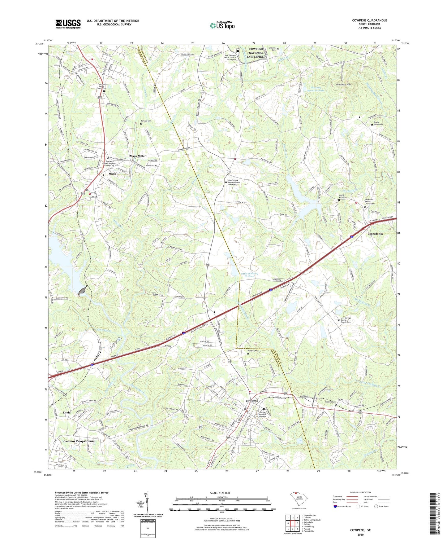
2020 topographic map quadrangle Cowpens in the state of South Carolina. Scale: 1:24000. Based on the newly updated USGS 7.5' US Topo map series, this map is in the following counties: Spartanburg, Cherokee. The map contains contour data, water features, and other items you are used to seeing on USGS maps, but also has updated roads and other features. This is the next generation of topographic maps. Printed on high-quality waterproof paper with UV fade-resistant inks.
Quads adjacent to this one:
West: Valley Falls
Northeast: Boiling Springs South
East: Gaffney
Southeast: Pacolet Mills
South: Pacolet
Southwest: Spartanburg
Contains the following named places: Ambu - Star Ambulance, Bellview Acres, Butler School, Calvary Baptist Church Cemetery, Cannons Camp Ground, Cannons Campground Church, Cannons Elementary School, Cash Family Cemetery, Central Baptist Church, Cherokee Creek, Chesnee Community Fire Department, Clearview Heights, Converse Road Mobile Home Park, Cowpens, Cowpens Elementary School, Cowpens Fire Department, Cowpens Junior High School, Cowpens Police Department, Cowpens Post Office, Dewberry Cemetery, Double Branch, Enola, First Baptist Church, Gardner Cemetery, Graham Chapel, Graham Chapel Wesleyan Church Cemetery, Island Creek, Island Creek Baptist Church, Island Creek Baptist Church Graveyard, Island Creek School, Little Thicketty Creek Pond, Long Branch of Island Creek, Love Springs, Love Springs Baptist Church, Love Springs Baptist Church Cemetery, Love Springs School, Macedonia, Macedonia Baptist Church, Macedonia Baptist Church Cemetery, Macedonia Division, Macedonia Elementary School, Macedonia Volunteer Fire Department, Macedonia Volunteer Fire Department Butler Substation, Mayo, Mayo Census Designated Place, Mayo Division, Mayo Elementary School, Mayo Fire Department, Mayo First Baptist Church Graveyard, Mayo Mills, Morgan Memorial Gardens, Mount Calvary Baptist Church Cemetery, Mount Olive Baptist Church, Mount Olive View School, Mount View Cemetery, Mount View Church, Mount View School, Mountain View Baptist Church Cemetery, New Pleasant Baptist Church, New Pleasant Baptist Church Graveyard, New Pleasant School, Oakdale Church, Palmetto Medical Transport Ambulance Service, Piedmont Baptist Church, Piedmont Baptist Church Cemetery, Piedmont School, Piney Grove Baptist Church Graveyard, Piney Grove Church, Pole Bridge Branch, Reynolds Mobile Home Park, Riverview Park, Scruggs Cemetery, Shady Grove Baptist Church, Shady Grove Cemetery, Shady Grove School, South Carolina Noname 11012 D-3403 Dam, South Carolina Noname 11013 D-1416 Dam, South Carolina Noname 11014 D-3399 Dam, South Carolina Noname 11018 D-3402 Dam, Spartanburg Emergency Medical Service Station 14, Springdale Estates, Sunny Slopes Pond Number One Dam D-3368, Sunny Slopes Pond Number Two Dam D-3367, Thicketty Creek WCD Dam Number 26, Thicketty Creek WCD Lake Number 26, Thicketty Mountain, Thicketty Mountain Church, Thicketty Mountain Lake, Thicketty Mountain School, Town of Cowpens, Trib Zekial Creek Pond, W Cash Pond Dam D-3325, Waters Cemetery, Watkins Cemetery, Whitlock Park, Williams Cemetery, WYFG-FM (Gaffney), Zekial Creek, ZIP Codes: 29330, 29368