MyTopo
Mauldin South Carolina US Topo Map
Couldn't load pickup availability
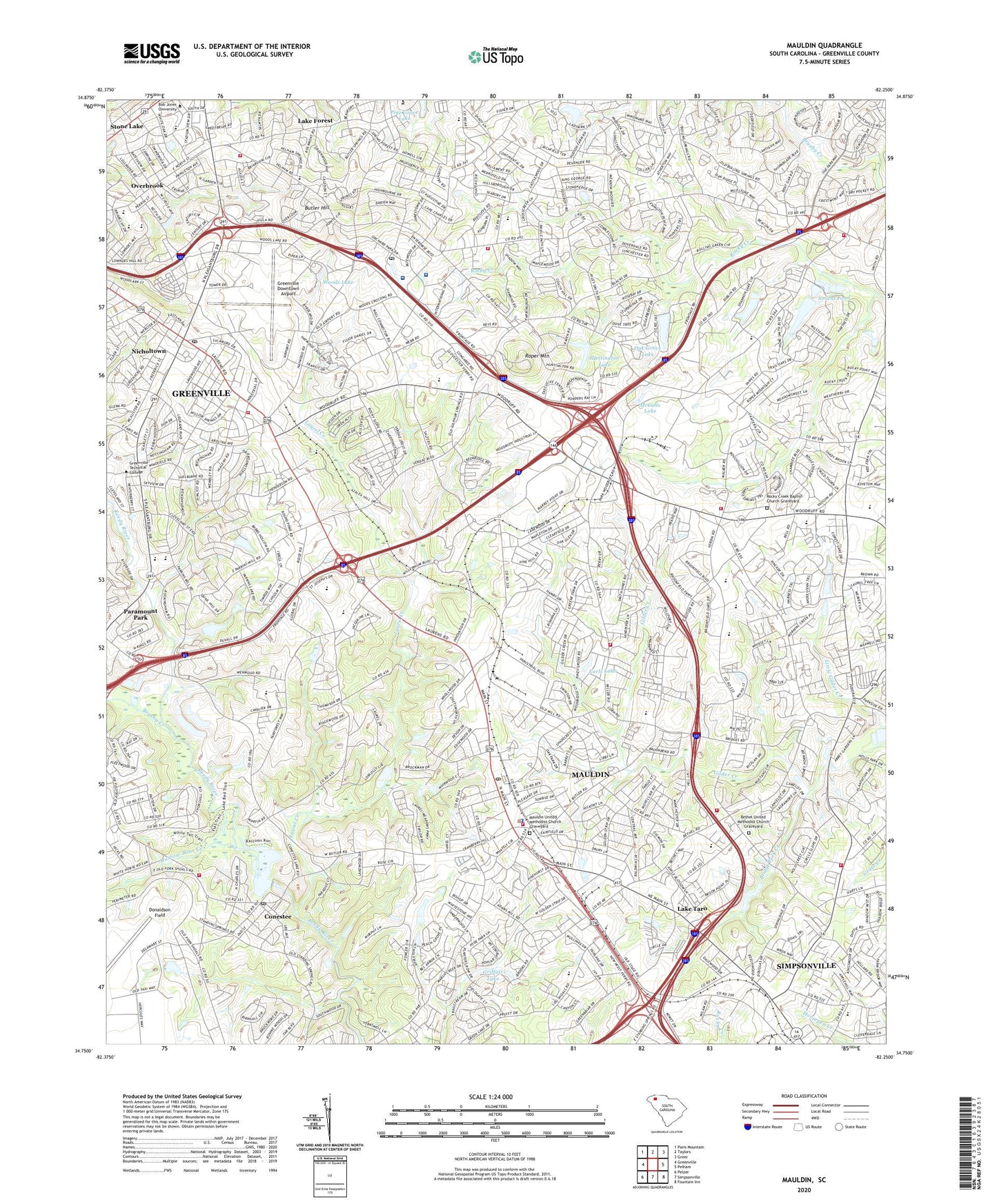
2020 topographic map quadrangle Mauldin in the state of South Carolina. Scale: 1:24000. Based on the newly updated USGS 7.5' US Topo map series, this map is in the following counties: Greenville. The map contains contour data, water features, and other items you are used to seeing on USGS maps, but also has updated roads and other features. This is the next generation of topographic maps. Printed on high-quality waterproof paper with UV fade-resistant inks.
Quads adjacent to this one:
West: Greenville
Northwest: Paris Mountain
North: Taylors
Northeast: Greer
East: Pelham
Southeast: Fountain Inn
South: Simpsonville
Southwest: Pelzer
Contains the following named places: Adams Mill Estates, Airport Church, Asheton, Augusta Acres, Barksdale, Beacon Hill, Beck Middle School, Belmont Fire Department, Belmont Heights, Bethany Church, Bethel Church, Bethel Elementary School, Bethel School, Bethel United Methodist Church Graveyard, Birdfield Estates, Bishop Heights, Bob Jones University, Boiling Spring School, Boiling Springs Church, Boiling Springs Fire District Headquarters, Bon Secours Saint Francis Health System Eastside, Bridge Fork Creek, Bridge Fork Creek Dam D-2904, Brookfield East, Brookfield West, Brookside, Brushy Creek, Burns Corner Shopping Center, Butler Hill, Butler Springs Park, Camelot, Cavalier Heights, Cavalier Woods, Center for Special Surgery, Chaunessy, Christ Church School, City of Greenville, City of Mauldin, College Heights, Collins Creek, Collins Lake Dam, Collins Pond, Collins Pond Dam D-2874, Conestee, Conestee Census Designated Place, Conestee Lake, Cox Airport, Deerfield, Devenger Place, Donaldson Air Force Base, Donaldson Field, Donaldson Golf Course, Donaldson Heights, Dove Tree, E P Collins Lake Dam D-2875, Earls Lake, East Gantt Elementary School, East Highland Estates, East North Street Elementary School, Elleston Acres, Endoscopy Center of the Upstate, Fair Forest Church, Fair Forest School, Faith Church, Fern Creek, First Baptist Church of Mauldin Graveyard, Flat Rock Church, Flint Hill School, Forrester Woods, Foxcroft, Franklin Hills, Fraternal Order of Police, Glenwood Acres, Golden Strip Career Center, Golden Strip Industrial Park, Golden Strip Shopping Center, Gospel Church, Gower Estates, Gower Estates Park, Grace Covenant Presbyterian Church, Graceland East Memorial Park Cemetery, Green Fields, Greenbrier Church, Greenbrier Elementary School, Greenville City Fire Department Station 5, Greenville City Fire Department Station 6, Greenville Division, Greenville Downtown Airport, Greenville Endoscopy Center at Patewood, Greenville Health System Patewood Memorial Hospital, Greenville Hospital System Patewood Outpatient Surgery Center, Greenville Mall Shopping Center, Greenville Middle School, Greenville Technical Community College, Greer Memorial Church, Greers Pond, Griffins Lake, Hartness Airport, Haywood Mall Shopping Center, Heritage Lakes, Hillcrest Middle School, Hillsborough, Holly Springs, Hudson Acres, Huntington Acres, Huntington Downs, Huntington Lake, Isaqueena Park, Isbell Heights, J B Greer Pond Dam D-2888, J L Mann High School, Jack W Greer Pond Dam D-2887, Jones Store, Kadi Medical Services, Kendall Green, Kings Road Industrial Park, Knollwood, Lake Fairfield, Lake Fairfield Dam D-2886, Lake Forest, Lake Forest Heights, Lake Taro, Landmark Church, Laurel Creek, Laurel Creek Church, Laurel Creek School, Laurel Heights, Lowndes Hill Church, Magnolia Acres, Marrow Bone Creek, Marshall Forest, Mauldin, Mauldin City Hall, Mauldin Elementary School, Mauldin Fire Department Headquarters, Mauldin Fire Department Station 1, Mauldin Fire Department Station 2, Mauldin High School, Mauldin Police Department, Mauldin Post Office, Mauldin United Methodist Church Graveyard, Maxwell Point Shopping Center, McAlister Square Shopping Center, McCalls Lake, Merchant Estates, Merrifield Park, Messiah Church, Mitchell Road Christian Academy, Molly Tree Plantation, Montclair, Montclaire, Mount Zion Church, Mountain Brook, New Hope Church, Nicholtown, North Gardens, North Hills Shopping Center, Oak Creek, Oak Grove Lake, Oak Grove School, Old Towne Shopping Center, Orchard Park, Palmetto Downs, Paramount Park, Parkins Lake, Parkwood, Pelham Road Church, Pelham Road Elementary School, Pine Forest, Pine Forest Church, Pine Grove Lake, Pleasantburg Industrial Park, Pleasantburg Shopping Center, Poplar Springs Church, Poplar Springs School, Quail Ridge, Reedy River Church, Ricelan Creek, Rock Hill Church, Rocky Creek Baptist Church Graveyard, Rocky Creek Church, Rogers Valley Heights, Roper Mountain, Roper Mountain Church, Roper Mountain Environmental Science Center, Rustic Estates, Saint Elizabeth Ann Seton Church, Saint Giles Church, Sara Collins Elementary School, Shannon Forest Christian School, Shannon Lake Dam D-2903, Sherwood Forest, Simpsonville Fire Department Station 3, Smiths Pond, South Carolina Highway Patrol Troop 3 Post C, South Carolina Noname 23014 D-2894 Dam, South Carolina Noname 23015 D-2902 Dam, South Carolina Noname 23016 D-2876 Dam, South Carolina Noname 23023 D-2893 Dam, Spring Forest, Springfield PArk, Stoneledge, Stratton Place, Summerwoods, Sunset Forest, Terra Oaks, Timberlake, Timmons Park, University Heights, Upstate Surgery Center, Verdin Estates, W J Barge Memorial Hospital, W R Cely Pond, W R Cely Pond Dam D-2892, Wade Hampton Fire Department Station 2, Wade Hampton Mall Shopping Center, Walkers Crossing, Watson Orchard, Wedgefield, Woodberry, Woodhedge, Woodland Homes, Woodruff Road Church, Woods, Woods Lake, Woodwinds, ZIP Codes: 29607, 29614, 29615, 29662