MyTopo
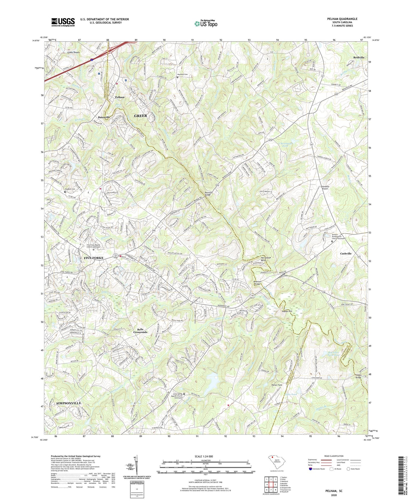
Pelham South Carolina US Topo Map
Couldn't load pickup availability
2020 topographic map quadrangle Pelham in the state of South Carolina. Scale: 1:24000. Based on the newly updated USGS 7.5' US Topo map series, this map is in the following counties: Greenville, Spartanburg, Laurens. The map contains contour data, water features, and other items you are used to seeing on USGS maps, but also has updated roads and other features. This is the next generation of topographic maps. Printed on high-quality waterproof paper with UV fade-resistant inks.
Quads adjacent to this one:
West: Mauldin
Northwest: Taylors
North: Greer
Northeast: Wellford
East: Reidville
Southeast: Woodruff
South: Fountain Inn
Southwest: Simpsonville
Contains the following named places: Abner Creek, Abner School, Adams Mill, Anderson Bridge, Antioch Presbyterian Church, Antioch Presbyterian Church Graveyard, Batesville, Bellingham, Bells Crossroads, Bennetts Bridge, Bob Jones Farm Pond, Bob Jones Farm Pond Dam D-2965, Brockmans Mill, Brushy Creek, Burnsview Baptist Church Graveyard, Burnsview Church, Carolina Center for Behavioral Health, Carolina Springs Country Club, Cashville, Cashville School, Chandelle Airport, Church of God, Clear Spring Baptist Church Graveyard, Clear Spring Church, Clear Spring Fire and Rescue Headquarters, Clear Spring Fire and Rescue Station 2, Community Grove Church, Cooper Bridge, Cross Roads Baptist Church Graveyard, Crossroads Church, Dillard Creek, Durham Grove Church, Durham Grove School, E Antley Pond Dam D-2789, East Simpsonville Fire Department Bethany, East Simpsonville Fire Department Georgia, Ebenezer Church, Five Forks, Five Forks Baptist Church, Five Forks Baptist Church Graveyard, Five Forks Census Designated Place, Ford Bridge, Fords Mill, Fulton Church, Fulton Presbyterian Church Graveyard, G Brockman Pond, G Brockman Pond Dam D-3350, Gibbs Pond, Gibbs Pond Dam D-3026, Gibbs Shoals, Gilder Creek, Graze Branch, Graze Creek, Harpers Folly Lake, Horsepen Creek, Horseshoe Bend, Hughes Airport, Hunter Branch, Hutchings Mill, Indian Hill, J Brockman Pond Dam D-2788, J P Stevens Pond, J P Stevens Pond Dam D-2901, Jonesville School, Kilgores Mill, Liberty Hill Church, Liberty Hill United Methodist Church Graveyard, Little Gilder Creek, Long Branch, Mayfield Cemetery, New Pilgrim Church, Old Pilgrim Church, Parker Field, Pelham, Pelham - Batesville Fire Department Station 1, Pelham - Batesville Fire Department Station 3, Pelham Falls, Pelham Industrial Park, Pelham Medical Center, Pelham Quarry, Pelham School, Peters Creek, Pliney School, Ponderosa, Reidville Division, Rocky Creek, Sharon Church, Sharon United Methodist Church Graveyard, Smiths Mill, South Carolina Noname 23005 D-2914 Dam, Stewart School, Surgery Center at Pelham, Vaughan Cemetery, Vaughans Mill, Vines Creek, Wesley Chapel, Whites Branch, Woodland Village, Woodlawn School, ZIP Code: 29681