MyTopo
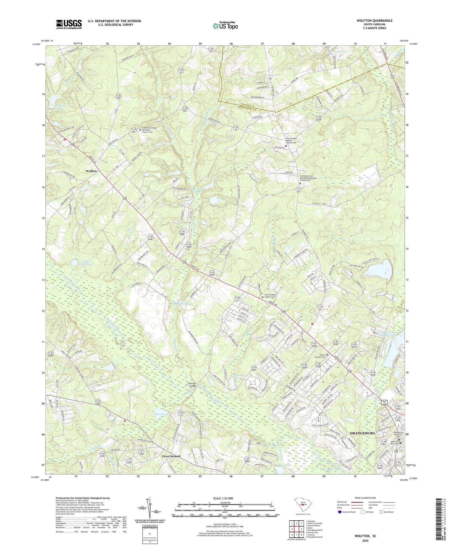
Wolfton South Carolina US Topo Map
Couldn't load pickup availability
2020 topographic map quadrangle Wolfton in the state of South Carolina. Scale: 1:24000. Based on the newly updated USGS 7.5' US Topo map series, this map is in the following counties: Orangeburg, Calhoun. The map contains contour data, water features, and other items you are used to seeing on USGS maps, but also has updated roads and other features. This is the next generation of topographic maps. Printed on high-quality waterproof paper with UV fade-resistant inks.
Quads adjacent to this one:
West: North
Northwest: Swansea
North: Staley Crossroads
Northeast: Saint Matthews
East: Orangeburg North
Southeast: Orangeburg South
South: Cordova
Southwest: Norway East
Contains the following named places: Annie Smith Pond, Boggy Branch School, Burke Creek, Butler Chapel, Calvary African Methodist Episcopal Church Cemetery, Calvary Church, Calvary School, Caw Caw Pond Dam D-3737, CCC Pond Dam D-3695, Chapel School, Club Acres, Country Club Estates, Country Club of Orangeburg, Davis Pond, Dixie Circle, Duncan Pond, Fannings Pond Dam D-3740, Forest Lake Estates, Fourmile Creek, Fraters Pond Dam D-3713, Gerwil Acres, Grape Branch, Great Branch, Greenfield, Gressette Woods, Hillview, Holy Trinity Catholic Church, J W Smoaks Pond, John Smiths Pond, Jones Chapel Baptist Church, Jones Chapel Baptist Church Cemetery, Kensington, Liberty Free Will Baptist Church, Limestone Church, Limestone Creek, Limestone United Methodist Church Cemetery, Little Limestone Creek, Livingston Terrace, Meadowridge, Memorial Park Cemetery, Mill Branch, Mill Branch School, Millwood Pond, Morningside of Orangeburg, Moses Temple, Moss Pond, Mount Calvary Cemetery, Mount Calvary Church, Mount Calvary School, Mount Pleasant Church, New Hope Baptist Church, North Lake Dam D-2309, North Ridge, Northside Lake, Oakmont, Orangeburg Fire Department Station 3, Orangeburg Memorial Cemetery, Perkins Pond, Perkins Pond Dam D-2646, Pine Needles, Pine Tops, Pinehill Fire Department, Randolph School, Robin Hill Farm, Saint Luke Church, Saint Stephen Church Cemetery, Saint Stephens Church, Sam Fogles Pond Dam D-3694, Scoville Woods, Sheridan Elementary School, Sheridan Estates, Shillings Bridge, Smoaks Pond Dam D-3714, South Carolina Noname 09046 D-2925 Dam, South Carolina Noname 38007 Dam, South Carolina Noname 38009 D-3736 Dam, South Carolina Noname 38010 D-3712 Dam, South Carolina Noname 38011 D-3738 Dam, South Carolina Noname 38048 D-3692 Dam, South Carolina Noname 38050 D-3711 Dam, South Carolina Noname 38052 D-3710 Dam, South Carolina Noname 38055 D-3697 Dam, South Carolina Noname 38056 D-3739 Dam, South Carolina Noname 38064 D-3718 Dam, T E Wannamaker Pond Number Two Dam D-3717, Turkey Hill Branch, Upper Limestone School, Wade Hampton Academy, Wannamaker Catfish Ponds, WAZQ-AM (Orangeburg), West Orange School, Willington Academy, Wolfton, Wolfton Fire Department, Wolfton School, Woodland, Woodland Pond Dam D-3698, Woodridge, WORG-AM (Orangeburg), ZIP Code: 29118