MyTopo
Big Junction Tennessee US Topo Map
Couldn't load pickup availability
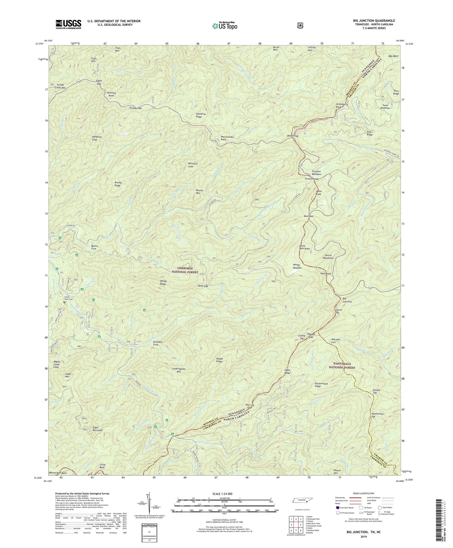
2019 topographic map quadrangle Big Junction in the states of Tennessee, North Carolina. Scale: 1:24000. Based on the newly updated USGS 7.5' US Topo map series, this map is in the following counties: Monroe, Graham, Cherokee. The map contains contour data, water features, and other items you are used to seeing on USGS maps, but also has updated roads and other features. This is the next generation of topographic maps. Printed on high-quality waterproof paper with UV fade-resistant inks.
Quads adjacent to this one:
West: Bald River Falls
Northwest: Rafter
North: Whiteoak Flats
Northeast: Tapoco
East: Santeetlah Creek
Southeast: Marble
South: McDaniel Bald
Southwest: Unaka
Contains the following named places: Bearpen Branch, Beaverdam Bald, Beech Gap, Big Cove Branch, Big Indian Branch Trail, Big Junction, Big Oak Cove Creek, Big Oak Cove Recreation Area, Birch Branch, Bob Bald, Bob Branch, Bob Creek, Brush Mountain, Brushy Ridge, Brushy Ridge Observation Site, County Corners, Dam Creek Recreation Area, Davis Creek, Davis Creek Recreation Area, Deep Gap, Dillard Top, Eagle Gap, Fain Cabin, Fain Ford, Fall Branch Scenic Area, Falls Branch, Falls Branch Trail, Flats Mountain, Fork Ridge, Gold Cove Branch, Grassy Branch, Grassy Branch Trail, Grassy Gap, Grassy Top, Green Cove Branch, Green Cove Cemetery, Hampton Lead, Haw Knob, Hemlock Knob, Hemlock Trail, Hogjaw Gap, Holder Cove Branch, Indian Branch, Jeffrey Trail, Jenks Branch, Johns Branch, Johns Knob, Kirkland Cove, Lake View Observation Site, Laurel Branch, Laurel Branch Trail, Laurel Top, Little Bald, Little Haw Knob, Lookingglass Mountain, Mangan Branch, Maple Camp Lead, McIntyre Lead, McNabb Creek Trail, Meadow Branch, Mistletoe Creek, Mitchell Lick, Mud Gap, Pantherflat Top, Peckerwood Creek, Peckerwood Ridge, Pheasant Field Fishing Site, Pheasant Field Rearing Pools, Pine Ridge, Pleasant Branch, Pleasant Field Rearing Pools, Queen Cove, Rattlesnake Rock, Red Log Gap, Roaring Branch, Rough Ridge, Rough Ridge Creek, Round Mountain, Round Mountain Branch, Rowe Lake, Rowe Lake Dam, Sassafras Ridge, Service Tree Branch, South Fork Citico Trail, Spivey Cove Recreation Area, Spivey Creek, State Line Recreation Area, State Ridge, Stratton Gap, Stratton Meadows, Strawberry Knob, Sugar Cove Branch, Sugar Cove Trail, Sugar Mountain, Sugar Mountain Lead, Sugar Mountain Trail, Swan Meadows, Sycamore Creek, Tellico River Lodge, Tipton Creek, Unicoi Mountains, Whigg Branch, Whigg Cabin, Whigg Meadow, Whigg Ridge, Whigg Ridge Trail