MyTopo
Dillton Tennessee US Topo Map
Couldn't load pickup availability
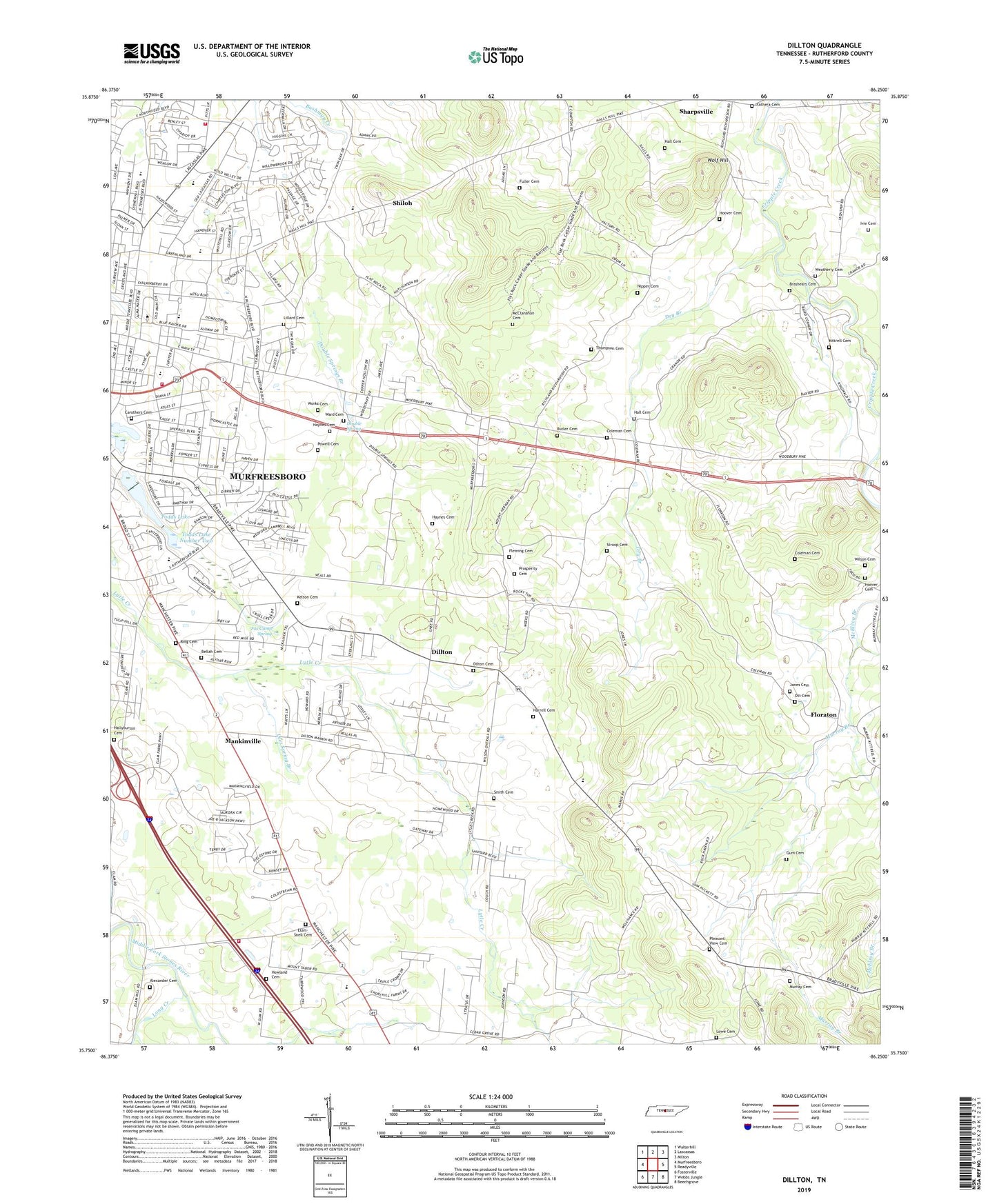
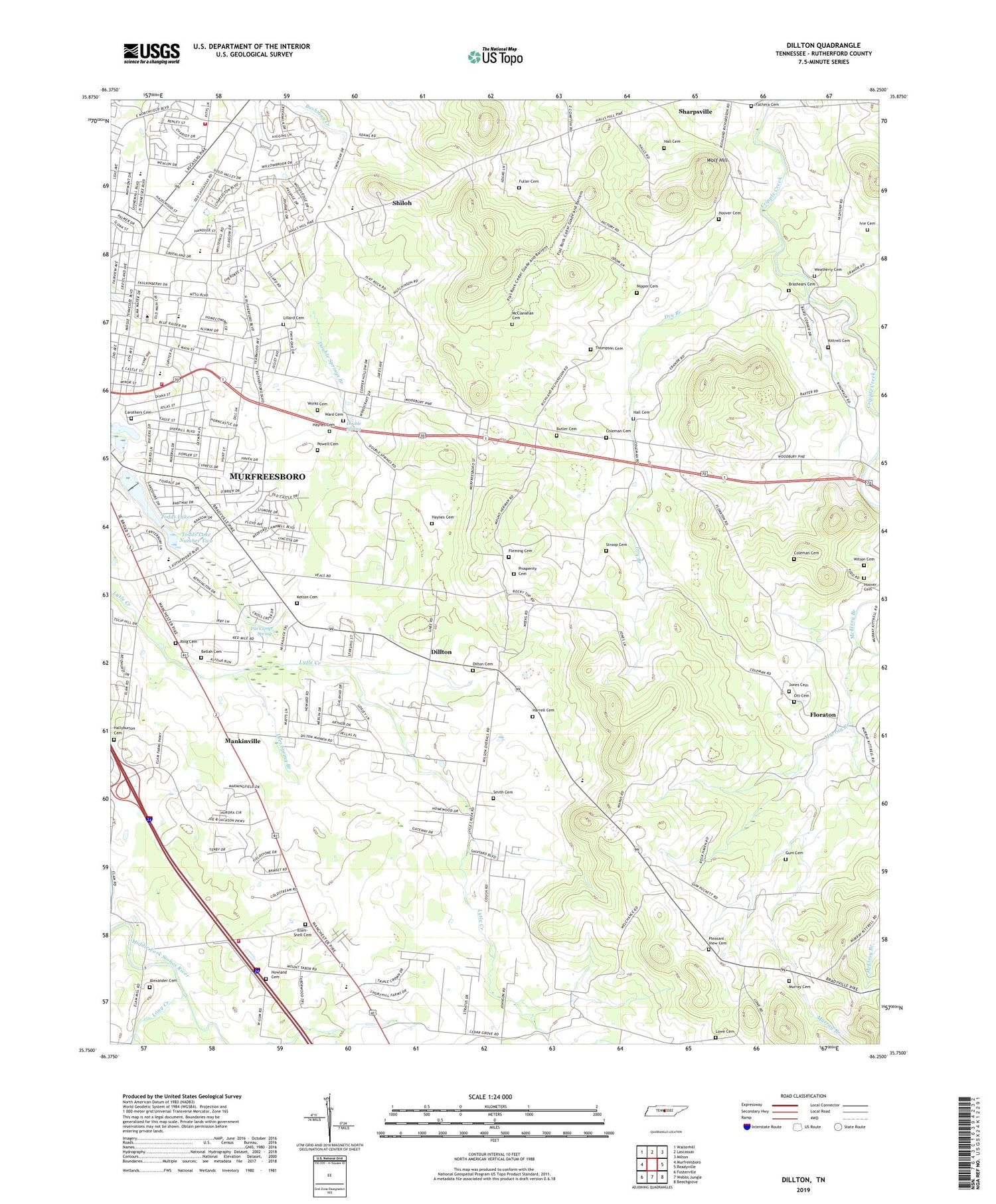
2019 topographic map quadrangle Dillton in the state of Tennessee. Scale: 1:24000. Based on the newly updated USGS 7.5' US Topo map series, this map is in the following counties: Rutherford. The map contains contour data, water features, and other items you are used to seeing on USGS maps, but also has updated roads and other features. This is the next generation of topographic maps. Printed on high-quality waterproof paper with UV fade-resistant inks.
Quads adjacent to this one:
West: Murfreesboro
Northwest: Walterhill
North: Lascassas
Northeast: Milton
East: Readyville
Southeast: Beechgrove
South: Webbs Jungle
Southwest: Fosterville
Contains the following named places: Alexander Cemetery, Alumni Center, Alumni Gym Pool, Alumni Memorial Gym, Beasley Hall, Bellah Cemetery, Boutwell Dramatic Arts Building, Brashears Cemetery, Brinkley School, Buchanan Elementary School, Burns Place, Butler Cemetery, Carothers Cemetery, Cedar Grove Church, Christianship Ministries Gathering of Disciples, Clement Hall, Coleman Cemetery, Commissioner District 17, Commissioner District 21, Commissioner District 4, Cope Administration Building, Corlew Hall, Coronado Square Shopping Center, Daniel McKee Speical Education School, Deere Hall, Dillton, Dilton Cemetery, Double Spring, Double Springs, Double Springs Branch, Dry Branch, Elam - Snell Cemetery, Ellington Human Sciences Building, Fathera Cemetery, Felder Hall, Fleming Cemetery, Floraton, Floyd Stadium, Forrest Hall, Fox Camp Meadows, Fox Camp Spring, Foxfire Farm, Fuller Cemetery, Gladeview School, Gore Hall, Gracy Hall, Gray Chapel, Greenbriar, Gum Cemetery, Hall Cemetery, Hallyburton Cemetery, Harrell Cemetery, Haynes Cemetery, Haynes Chapel, Henderson School, Hobgood Elementary School, Hoover Cemetery, Howland Cemetery, Ivie Cemetery, James Union Building, Jones Cemetery, Jones Field, Jones Hall, Judd Hall, Kelton Cemetery, Kirksey Old Main, Kittrell Cemetery, Kittrell Division, Kittrell Heights, Lascassas Villa, Lees Spring Branch, Lillard Cemetery, Lillard Farm Estates, Little Bethel Church, Long Creek, Lowe Cemetery, Mankinville, McClanahan Cemetery, McFarlin, Middle Tennessee State College, Midway Church, Mount Hermon Church, Mount Pleasant School, Mount Tabor, Mount Tabor Church, Murfreesboro Fire Department Station 3, Murfreesboro Fire Rescue Department Station 8, Murphy Athletic Center, Murray Branch, Murray Cemetery, Murray School, Nicks Hall, Nipper Cemetery, Norman Camp Grounds, North Boulevard Church of Christ, Ott Cemetery, Overall Acres, Park Manor, Peck Hall, Plaza South Shopping Center, Pleasant View, Pleasant View Cemetery, Pleasant View Church, Powell Cemetery, Prosperity Cemetery, Prosperity Church, Quail Run, Reeves Rodgers Elementary School, Reidhurst, Ridgecrest Acres, Ring Cemetery, Rutledge Hall, Saint Rose of Lima Catholic Church, Saint Rose of Lima School, Saunders Fine Arts Building, Scotland Acres, Sharpsville, Shiloh, Shiloh School, Sims Hall, Smith Baseball Field, Smith Cemetery, Smith Hall, Southeast Rutherford Volunteer Fire Department, State of Tennessee, Stroop Cemetery, Taylors Chapel, Thompson Cemetery, Todd Library, Todds Lake, Todds Lake Dam, Todds Lake Number Two, Todds Lake Number Two Dam, Tulip Hill Estates, Twin Springs, Voorhies Industrial Studies Building, Ward Cemetery, Weatherly Cemetery, Wilson Cemetery, WMOT-FM (Murfreesboro), Wolf Hill, Wood Hall, Woodbury Road Church, Woodmore Cafeteria, Works Cemetery, Yearwood Addition, ZIP Codes: 37127, 37132