MyTopo
Walterhill Tennessee US Topo Map
Couldn't load pickup availability
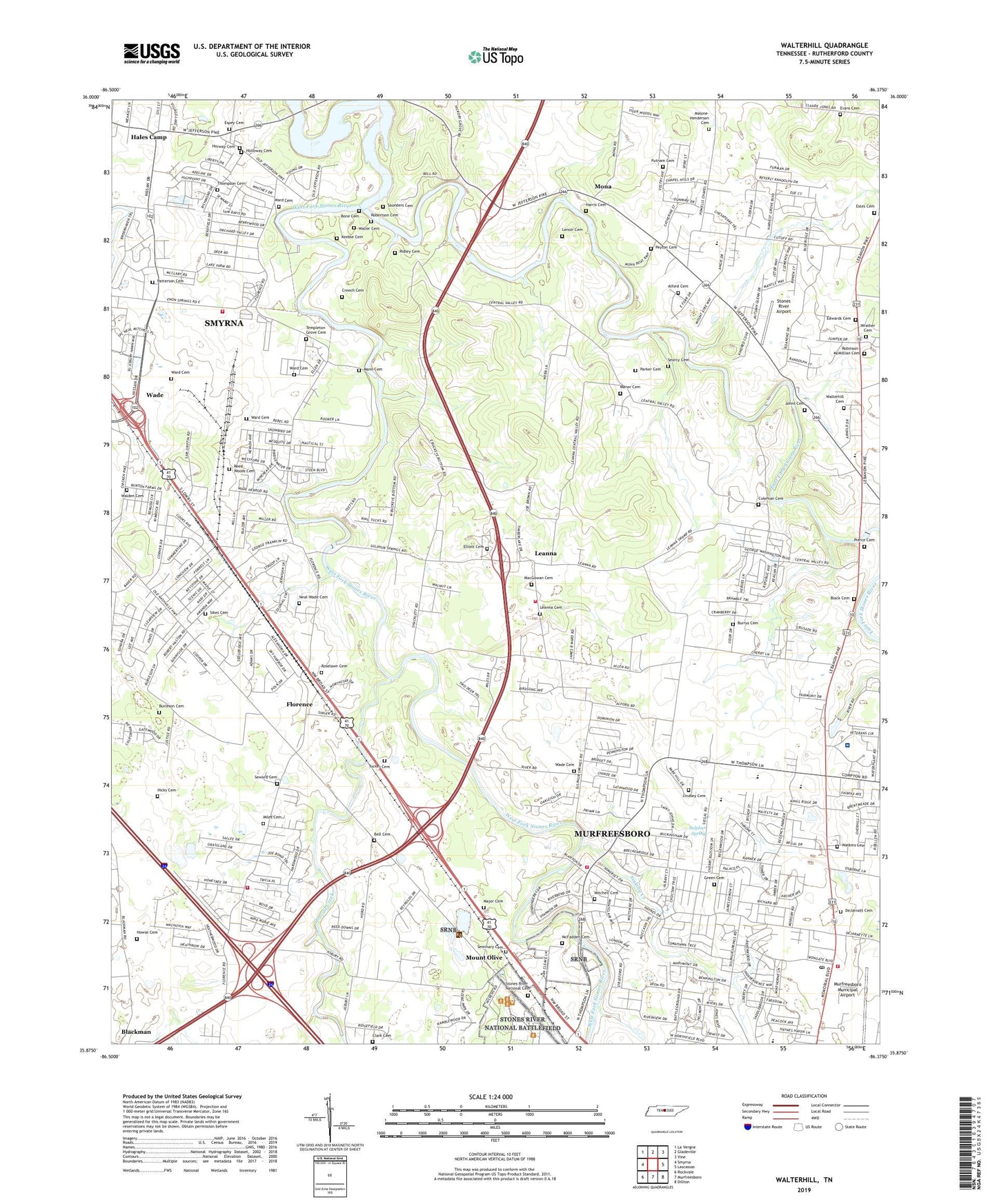
2022 topographic map quadrangle Walterhill in the state of Tennessee. Scale: 1:24000. Based on the newly updated USGS 7.5' US Topo map series, this map is in the following counties: Rutherford. The map contains contour data, water features, and other items you are used to seeing on USGS maps, but also has updated roads and other features. This is the next generation of topographic maps. Printed on high-quality waterproof paper with UV fade-resistant inks.
Quads adjacent to this one:
West: Smyrna
Northwest: La Vergne
North: Gladeville
Northeast: Vine
East: Lascassas
Southeast: Dillton
South: Murfreesboro
Southwest: Rockvale
This map covers the same area as the classic USGS quad with code o35086h4.
Contains the following named places: Alford Cemetery, Alvin York Veterans Administration Medical Center, Antioch Church, Asbury Church, Asbury Prk, BAttlefield Meadows, Bell Cemetery, Bethel, Bethel School, Bethel United Methodist Church, Black Cemetery, Blackman, Blackman Church, Blansett Meadows, Bone Cemetery, Burleson Cemetery, Burrus Cemetery, Cherry Hill Estates, Cherry Lane Acres, Clark Cemetery, Coleman Cemetery, Colonial Village, Commissioner District 14, Commissioner District 15, Commissioner District 19, Commissioner District 3, Confederate Glen Estates, Cooks Corner, Creech Cemetery, Creekmont, DeJarnatt Cemetery, East Fork Recreation Area, East Fork Stones River, Ebenezer Church, Edwards Cemetery, Elliott Cemetery, Espey Cemetery, Estes Cemetery, Evans Cemetery, Fairmont, Florence, Florence Baptist Church, Florence Church, Georgetown, Green Cemetery, Hales Camp, Halewood Hills, Harris Cemetery, Haynes Haven, Henry Lane, Hickory Grove, Hickory Grove Church, Hickory Grove School, Hicks Cemetery, Hillwood Estates, Holloway Cemetery, Hooper Acres, Horway Cemetery, Howse Cemetery, Indian Springs, Jamestown, Jerusalem Church, Johns Cemetery, Joneswood, Joywood, Juniper Acres, Keeble Cemetery, Key Estates, Kings Estates, Lake Farm Estates, Lamb, Leanna, Leanna Cemetery, Leanna Church of Christ, Lenoir Cemetery, Lifeguard Ambulance Service of Tennessee Rutherford, Lindsey Cemetery, Little Ranch Acres, Lone Oak School, MacGowan Cemetery, Major Cemetery, Malone-Henderson Cemetery, Mann Cemetery, Manor Cemetery, McFadden Cemetery, McFaddens Ford, Miles Cemetery, Miller Estates, Mitchell Cemetery, Mona, Mono Recreation Area, Mount Olive, Mud Flat School, Murfreesboro Fire Department Station 6, Murfreesboro Fire Rescue Department Station 5, Murfreesboro Fire Rescue Department Station 7, Murfreesboro Municipal Airport, Murfreesboro Post Office, Murfreesboro Wastewater Treatment Plant, Neals Mill, Neal-Wade Cemetery, Nestledown Estates, Nice Mill Dam Recreation Area, Northfield Elementary School, Northpointe Hall, Old Jefferson, Overall Creek, Palmer Heights, Parker Cemetery, Patterson Cemetery, Peyton Cemetery, Pierce Cemetery, Pioneer Estates, Providence Church, Putnam Cemetery, Ravenwood, Reed-Woods Cemetery, Regency Park, Reynolds, Ridgefield, Ridley Cemetery, Riverbend, Riverview, Robertson Cemetery, Robinson-McMillian Cemetery, Roselawn Cemetery, Rowland Estates, Royal Court, Saunders Cemetery, Searcy Cemetery, Seminary Cemetery, Seward Cemetery, Sikes Cemetery, Silver Springs Baptist Church, Silver Springs School, Sinking Creek, Smyrna Fire Department Station 3, Stones River Airport, Stones River National Battlefield, Stones River National Cemetery, Sulphur Spring, Sunnyside, Templeton Grove Cemetery, Thompson Cemetery, Timberlake, Tucker Cemetery, Wade, Wade Cemetery, Walden Cemetery, Waller Cemetery, Walter Hill Elementary School, Walter Hill Estates, Walter Hill High School, Walter Hill Volunteer Fire Department Station 2, Walterhill, Walterhill Cemetery, Ward Cemetery, Wards Mill, Watkins Cemetery, West Fork Recreation Area, West Fork Stones River, White Haven, Williamsburg, Wrather Cemetery, Yorktown, ZIP Code: 37129