MyTopo
East Chattanooga Tennessee US Topo Map
Couldn't load pickup availability
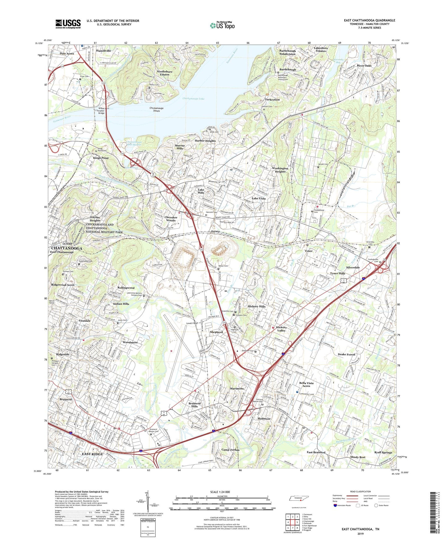
2019 topographic map quadrangle East Chattanooga in the state of Tennessee. Scale: 1:24000. Based on the newly updated USGS 7.5' US Topo map series, this map is in the following counties: Hamilton. The map contains contour data, water features, and other items you are used to seeing on USGS maps, but also has updated roads and other features. This is the next generation of topographic maps. Printed on high-quality waterproof paper with UV fade-resistant inks.
Quads adjacent to this one:
West: Chattanooga
Northwest: Fairmount
North: Daisy
Northeast: Snow Hill
East: Ooltewah
Southeast: Ringgold
South: East Ridge
Southwest: Fort Oglethorpe
Contains the following named places: Acres of Shade Mobile Home Park, Anna B Lacey School, Antioch Church, Austin Farm, Barger Academy, Bartlebaugh, Bartlebaugh Missionary Church Cemetery, Battery Heights, Bayview, Bella Vista Acres, Bess T Shepherd Elementary School, Birds Mill, Bonny Oaks School, Booker T Washington Elementary School, Booker T Washington State Park, Boyd Buchanan School, Brainerd, Brainerd Baptist School, Brainerd Golf Course, Brainerd High School, Brainerd Hills, Brainerd Junior High School, Brainerd Mission Cemetery, Brainerd Park, Brainerd Post Office, Brainerd Village Shopping Center, Brannan-Montague Mine, Brentwood, Brookfield, Brown Middle School, Cambridge Estates, Camp Jordan, Camp Jordan Park, Capital Heights, Central High School, Chattanooga - Hamilton County Fire and Rescue, Chattanooga Airport Fire Department, Chattanooga Division, Chattanooga Fire Department Station 13, Chattanooga Fire Department Station 15, Chattanooga Fire Department Station 21, Chattanooga Fire Department Station 6, Chattanooga Fire Department Station 8, Chattanooga Main Office Window Post Office, Chattanooga Quarry, Chattanooga State Area Vocational Technical School, Chattanooga State Technical Community College, Cherokee Woods, CHI Memorial Hospital Hixson, Chickamauga Boat Harbor, Chickamauga Dam, Chickamauga Dam Day Use Area, Chickamauga Elementary School, Chickamauga Island, Chickamauga Post Office, Chickamauga School, Chickamauga Shoals, City of Chattanooga, City of Ridgeside, Civilian Conservation Corps Camp Number 3459, Commissioner District 5, Commissioner District 8, Concord Baptist Cemetery, Concord Golf Course, Concord Heights, Confederate Cemetery, Creekwood Terrace, Dale Acres, Dalewood Middle School, Dawn School, Deerwood Forest, Drake Forest, East Brainerd Elementary School, East Chattanooga, Eastdale, Eastdale Elementary School, Eastgate Post Office, Eastgate Shopping Center, Edgemont Forest, Ela Wada Terrace, Elbert S Long Elementary School, Engleton Heights, Erlanger East Hospital, Faith Church, Forest Hills, Foxwood Heights, Friar Branch, Friars Island, Fryar Cemetery, Gaylan Heights, Glenmar Hills, Gold Point Marina, Grace Church, Greenhill Cemetery, Greenwood Cemetery, Hamillville, Hamilton County Correctional Facility, Hamilton County Nursing Home, Hamilton County Workhouse, Hancock Cemetery, Harbor Heights, Harbour Woods, Harrison, Harrison Elementary School, Harrison Point, Harrison Post Office, Hawkinsville Church, Heritage Hills, Hickory Hills, Hickory Valley, Hickory Valley Church, Hickory Valley Golf Course, Hickory Valley Shopping Center, Highland Memorial Gardens, Highway 58 Shopping Center, Highway 58 Volunteer Fire Department Station 1, Hillcrest Elementary School, Hillsboro Heights, Holiday Hills, Holy Hills, Indian Hills, Isabella Stewart Mine, Jersey, Jersey School, Johnson Cemetery, Jones Cemetery, Kings Point, Kings Point Cemetery, Kings Point Church, Kings Point School, Kirklin Cemetery, Lake Hills, Lake Hills Church, Lake Hills Shopping Center, Lake Junior, Lake Vista, Lakeshor Manor, Lakeshore, Lakeshore Estates, Lakeside Elementary School, Lakewood Memory Gardens East, Lee Plaza East Shopping Center, Logan Heights, Lovell Field, Lutheran School, Marimont, McCarty Church, McCarty Station, Min-Tom Childrens Home, Morris Hill Church, Mount Calvary Church, Mount Joy Church, Murray Hills, Murray Lake Hills Post Office, National Knife Museum, Nixon Prospect, North Brainerd, North Chickamauga Creek, North Tower Forest, Northshore Estates, Oak Hill School, Oakwood Church, Our Lady of Perpetual Help School, Perimeter Place Shopping Center, Pineoak Heights, Pitner Field, Plaza 58 Shopping Center, Pleasant Gardens Cemetery, Pleasant Hill Church, Poe Branch, Privateer Yacht Club, Radmoor, Regency Place, Ridgeview Church, Ridgewood Acres, Riggs Trailer Park, River Oaks, Rollingwood, Royal Oaks, Ryall Springs Branch, Saint James Church, Saint Johns Church, Saint Stephens School, Saint Thaddaeus Church, Shady Rest, Shallowford Hills, Shawnee Park, Shepherd, Shepherd Cemetery, Shepherd Community Cemetery, Silverdale, Silverdale Cemetery, Smith Cemetery, South Brainerd, South Terrace Plaza Shopping Center, Spring Creek, Stewart Cemetery, Stubblefield Cemetery, Sunnyside Elementary School, Talley Place, Tennessee Highway Department, Tennessee Valley Railroad Museum, Terra Vista Church, The Childrens Home, Theresa Heights, Treasure Cove Shopping Center, Trinity Baptist Church, Trinity Woodmore United Methodist Church, Turkeyfoot, Tyner, Tyner High School, Tyner Hills, Tyner Junior High School, Tyner Post Office, Varnell Cemetery, Vista Hills, Volunteer Army Ammunition Plant, Waconda Bay, Washington Heights, Washington Hills, Washington Place, Welcome Valley Baptist Church, Wesley Memorial Church, WGCA-AM (Chattanooga), Whispering Pines Mobile Home Park, Wilkes T Thrasher Bridge, William L Bork Memorial Hospital, Wilson Cemetery, Woodmore, Woodmore Elementary School, Worley, ZIP Codes: 37406, 37411, 37416, 37421