MyTopo
Snow Hill Tennessee US Topo Map
Couldn't load pickup availability
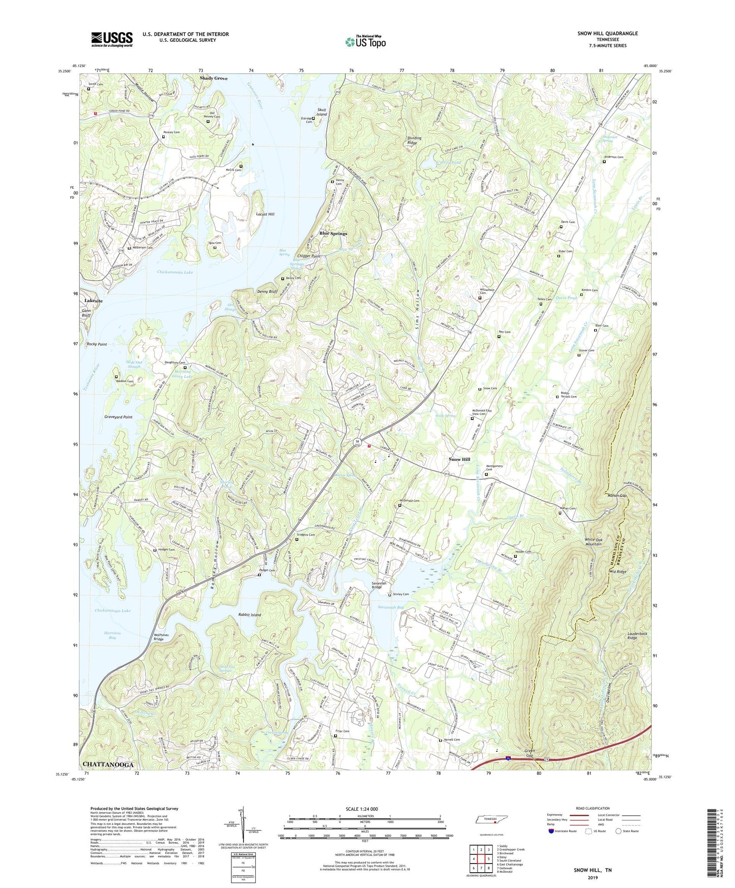
2022 topographic map quadrangle Snow Hill in the state of Tennessee. Scale: 1:24000. Based on the newly updated USGS 7.5' US Topo map series, this map is in the following counties: Hamilton, Bradley. The map contains contour data, water features, and other items you are used to seeing on USGS maps, but also has updated roads and other features. This is the next generation of topographic maps. Printed on high-quality waterproof paper with UV fade-resistant inks.
Quads adjacent to this one:
West: Daisy
Northwest: Soddy
North: Grasshopper Creek
Northeast: Birchwood
East: South Cleveland
Southeast: McDonald
South: Ooltewah
Southwest: East Chattanooga
This map covers the same area as the classic USGS quad with code o35085b1.
Contains the following named places: Anderson Cemetery, Anderson Spring, Bass Bay Marina, Birchwood Landfill, Blair Cemetery, Blue Spring, Blue Spring Creek, Blue Springs, Blue Springs Slough, Camp Hacoba, Camp Joy, Carson Spring, Chigger Point, City of Chattanooga Landfill, Commissioner District 9, Cross Roads Church, Currey Pond, Daughtrey Cemetery, Davis Cemetery, Davis Pond, Denny Bluff, Denny Cemetery, Denny Hill Church, Elder Cemetery, Eldridge Cemetery, Freedom Church, Frog Level Branch, Fryar Cemetery, Gann Bluff, Graveyard Point, Green Acres Equestrian Farm, Green Branch, Green Gap, Greenwood Church, Harrison Bay State Park, Harrison Bay Vocational Technical Center, Hide Out Slough, Highland Manor, Highway 58 Volunteer Fire Department Station 2, Hodges Cemetery, Holder Cemetery, Hunter Hills, Igou Cemetery, Igous Ferry, Ison Spring Branch, Jones Bay, Kimbro Cemetery, Lake Crest, Lakeway Church, Lakewood Church, Lauderback Ridge, Lewis Branch, Locust Hill, Long Savannah Creek, Loret Villa, Maddox School, Maddux Cemetery, Mahan Cemetery, Mahan Gap, Maple Grove Church, Maple Hollow, Masterson Cemetery, McDonald Cemetery, McDonald East View Cemetery, McGill Cemetery, Middle Ridge, Montgomery Cemetery, Moon Curve, Moon Shadows, Morgan Estates, Morning Glory Lake, New Bethel Baptist Church, New Shepherd Hill Church, Oak Grove Church, Old Penney Cemetery, Ooltewah Lookout Tower, Orr Slough, Owl Hollow, Padget Cemetery, Penney Cemetery, Pinebrook Estates, Providence Church, Rabbit Island, Ramsey Hollow, Ray Cemetery, Rector Spring, Rock Ledge Estates, Rocky Point, Roddy-Yarnell Cemetery, Rogers Branch, Runyan Spring Branch, Savannah Bay, Savannah Bridge, Savannah Church, Savannah Hills, Savannah Peninsula, Scoggins Cemetery, Scoggins Mill, Sequoyah Nuclear Plant, Sequoyah Volunteer Fire Department, Shirley Cemetery, Shirley Pond, Short Tail Springs, Sims Hollow, Skull Island, Skull Island Recreation Area, Smith Cemetery, Snow Cemetery, Snow Hill, Snow Hill Division, Snow Hill Elementary School, Soap Box Derby Track, Stover Cemetery, Summer Haven, Taliaferro Branch, Talley Cemetery, Varnell Cemetery, Varnell Creek, Williamson Cemetery, Wolfe Branch, Wolfe Spring, Wolftever Bridge, Wolftever Creek, Wolftever Fishing Club, WQLS-FM (Cleveland), ZIP Code: 37341