MyTopo
Erwin Tennessee US Topo Map
Couldn't load pickup availability
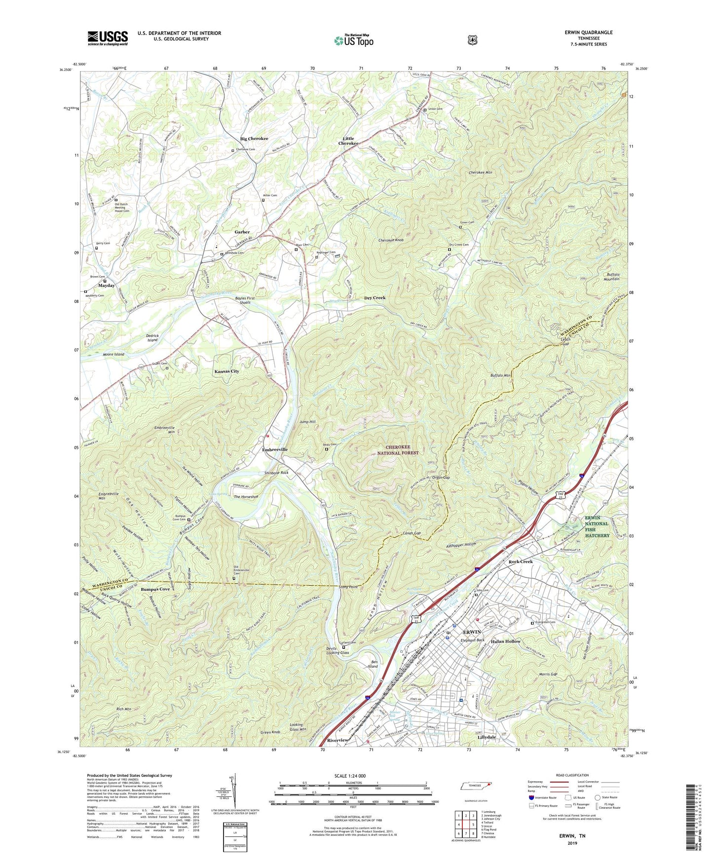
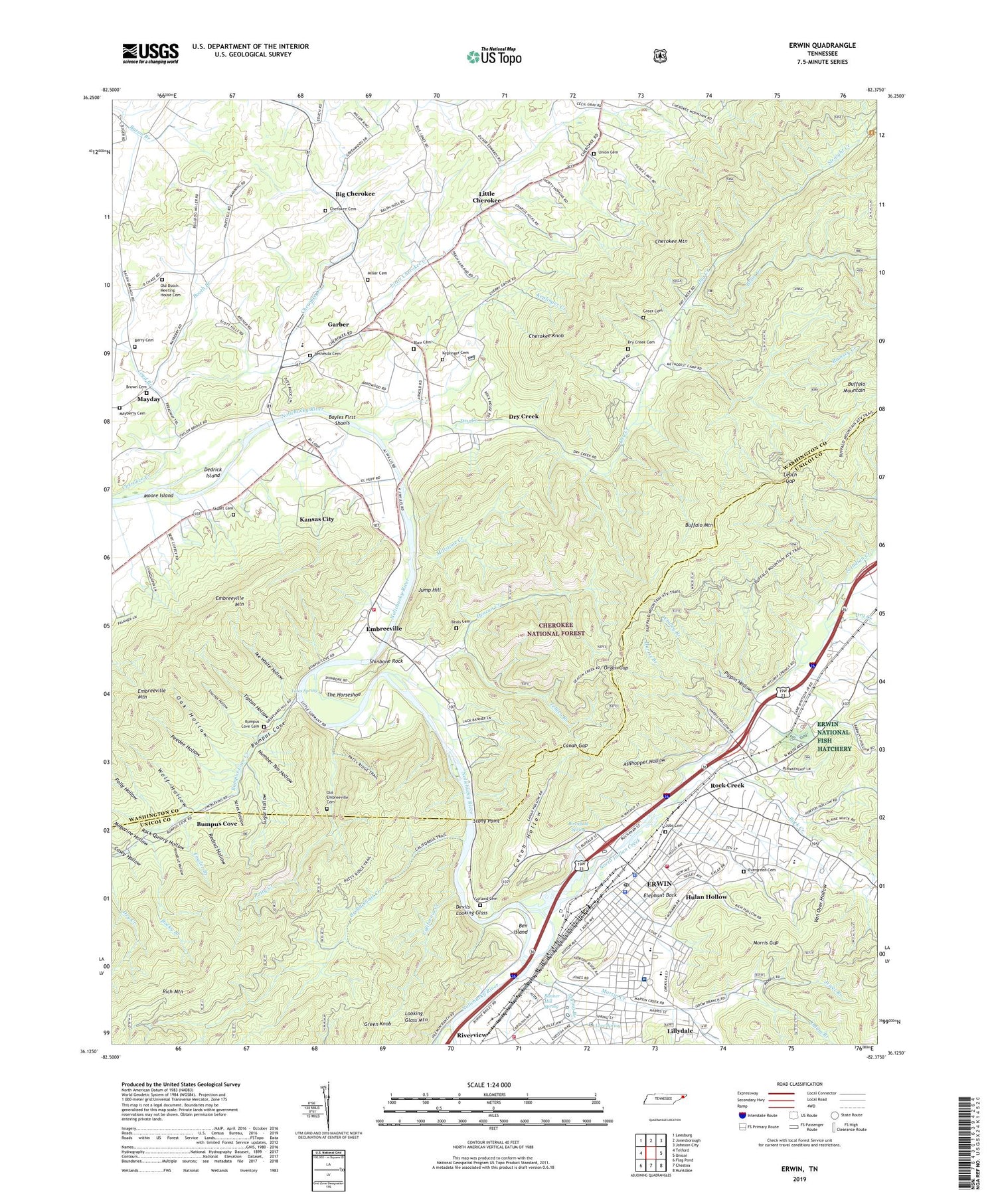
2019 topographic map quadrangle Erwin in the state of Tennessee. Scale: 1:24000. Based on the newly updated USGS 7.5' US Topo map series, this map is in the following counties: Washington, Unicoi. The map contains contour data, water features, and other items you are used to seeing on USGS maps, but also has updated roads and other features. This is the next generation of topographic maps. Printed on high-quality waterproof paper with UV fade-resistant inks.
Quads adjacent to this one:
West: Telford
Northwest: Leesburg
North: Jonesborough
Northeast: Johnson City
East: Unicoi
Southeast: Huntdale
South: Chestoa
Southwest: Flag Pond
Contains the following named places: Ashhopper Hollow, Banner Hill, Banner Hill Spring, Bayles First Shoals, Beals Cemetery, Bend Island, Berry Cemetery, Bethany Lutheran Church, Bethel Church, Bethesda Cemetery, Bethesda Division, Bethesda United Methodist Church, Big Cherokee, Birchfield Spring, Blair Cemetery, Booth Branch, Briar Creek, Broad Shoal Creek, Brown Cemetery, Buchanan School, Bumpus Cove, Bumpus Cove Cemetery, Bumpus Cove Creek, Bumpus Cove School, California Creek, California Trail, Canah Gap, Canah Hollow, Canah School, Casey Hollow, Centenary United Methodist Church, Cherokee Cemetery, Cherokee Church, Cherokee Knob, Cherokee Mountain Baptist Church, Cherry Grove Church, Church of Christ, Clinchfield YMCA, Commissioner District 10, Commissioner District 2, Davenport Mine, Deacon Creek, Decker Farm Airport, Dedrick Island, Devils Looking Glass, District 4, District 6, District 8, Dry Creek, Dry Creek Cemetery, Dry Creek School, Elephant Back, Elm Street Public School, Embree Number 13 Mine, Embree Number 14 Mine, Embree Number 15 Mine, Embrees Dam, Embreeville, Embreeville Census Designated Place, Embreeville Cove Baptist Church, Embreeville School, Embreeville United Methodist Church, Embreeville Volunteer Fire Department, Erwin, Erwin City Hall, Erwin Division, Erwin Fire Department, Erwin National Fish Hatchery, Erwin Police Department, Erwin Post Office, Erwin Presbyterian Church, Evans Elementary School, Evergreen Cemetery, First Baptist Church, First Free Will Baptist Church, Fishery, Fowler Branch, Fowler Mine, Garber, Garbers Station, Garland Cemetery, Green Knob, Greer Cemetery, Harris Branch, Henleys Ford, Horse Cove Gap, Hulan Hollow, Ike White Hollow, Jackson Mine, Jewel Branch, Jewell Prospect, Jobe Cemetery, Jump Hill, Kansas City, Keplinger Cemetery, Keplinger Creek, Klondike Mine, Lamar Elementary School, Leach Gap, Lillydale, Little Cherokee, Little Cherokee Creek, Little Polly Hollow Mine, Looking Glass Mountain, Love Spring, Lower Peedee Mine, Lower Red Cut Mine, Loyd Branch, Magazine Hollow, Martin Chapel Elementary School, Martin Creek, Mayberry Cemetery, Mayberry School, Mayday, Medicone Medical Response, Miller Cemetery, Millstone Creek, Moore Island, Morris Gap, New Era School, Ninth Street Baptist Church, North Indian Creek, Number Five Mine, Number Ten Hollow, Number Ten Mine, Oak Hollow, Odom Branch, Old Dutch Meeting House Cemetery, Old Embreeville Cemetery, Organ Gap, Patty Creek, Patty Ridge Trail, Peedee Hollow, Pentecostal Holiness Church, Pippin Hollow, Polly Hollow, Polly Hollow Mine, Ramsey Creek, Redcut Hollow, Rock Creek, Rock Creek Church, Rock Creek Elementary School, Rock Quarry Hollow, Rock Quarry Hollow Mine, Rocky Branch, Sandy Bottom Bridge, Seminary School, Shinbone Rock, South Indian Creek, Southside Volunteer Fire Department, Spring Branch, Starnes Hollow, Stony Point, Straight Creek, Stuart Cemetery, Sugar Hollow, Sugar Hollow Mine, Taylor Bridge, Tellico Branch, The Horseshoe, Tipton Hollow, Town of Erwin, Tucker Mine, Tunnel Mine, Unaka Ranger Station, Unicoi County Courthouse, Unicoi County High School, Unicoi County Jail, Unicoi County Memorial Hospital, Unicoi County Sheriff's Office, Unicoi Wildlife Management Area, Union Cemetery, Union Church, Upper Peedee Mine, Upper Red Cut Mine, Van Over Hollow, Vincent United Methodist Church, Warren Prospect, Whaley Branch, Wolf Hollow, Woodcut Hollow, Yates Hollow, Yates Hollow Mine, Yates Spring