MyTopo
Telford Tennessee US Topo Map
Couldn't load pickup availability
Also explore the Telford Forest Service Topo of this same quad for updated USFS data
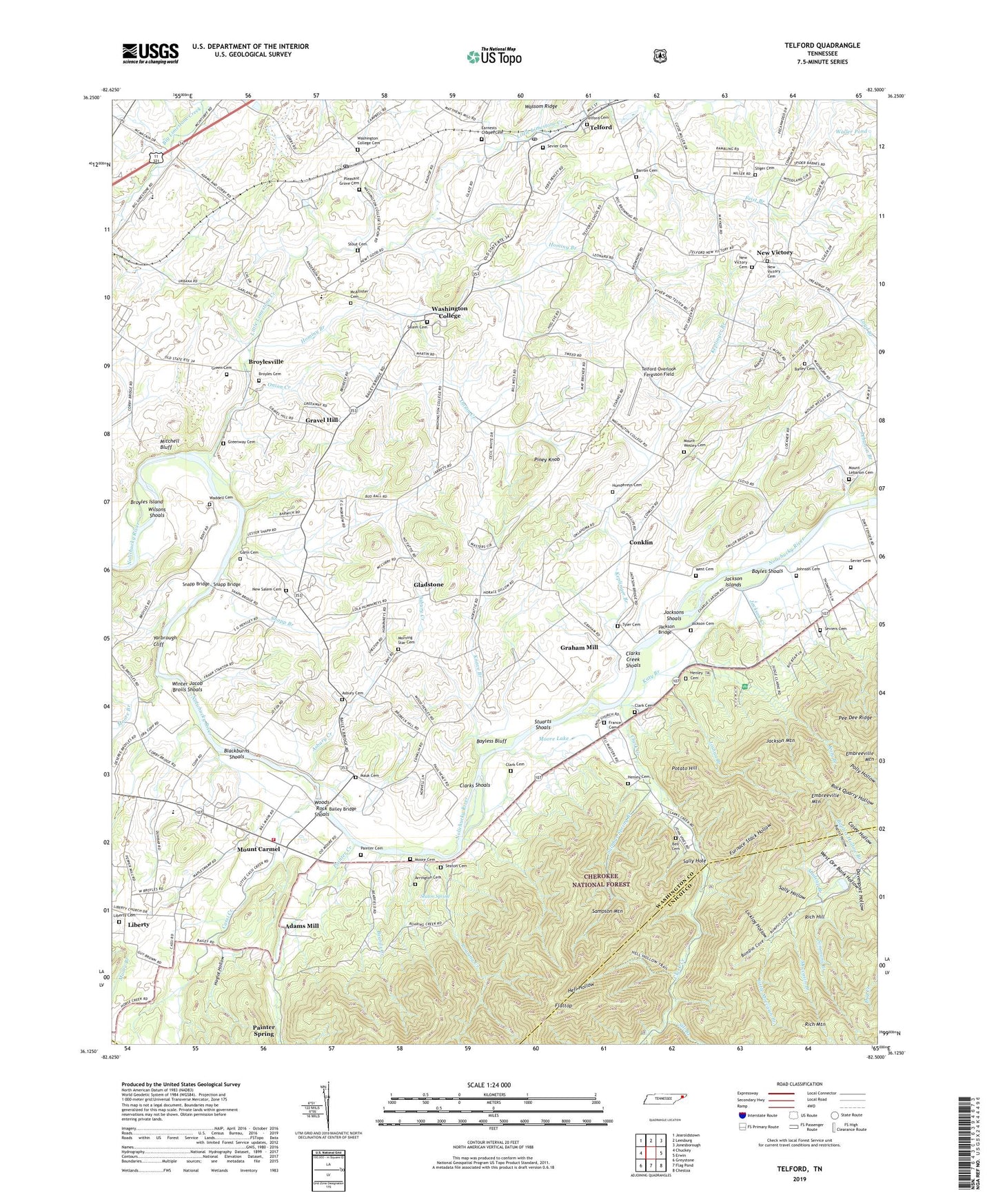
2022 topographic map quadrangle Telford in the state of Tennessee. Scale: 1:24000. Based on the newly updated USGS 7.5' US Topo map series, this map is in the following counties: Washington, Unicoi, Greene. The map contains contour data, water features, and other items you are used to seeing on USGS maps, but also has updated roads and other features. This is the next generation of topographic maps. Printed on high-quality waterproof paper with UV fade-resistant inks.
Quads adjacent to this one:
West: Chuckey
Northwest: Jearoldstown
North: Leesburg
Northeast: Jonesborough
East: Erwin
Southeast: Chestoa
South: Flag Pond
Southwest: Greystone
This map covers the same area as the classic USGS quad with code o36082b5.
Contains the following named places: Adams Mill, Arrington Cemetery, Asbury Cemetery, Asbury Church, Asbury Creek, Asbury United Methodist Church, Bailey Bridge, Bailey Cemetery, Baptist Hollow, Baptist Hollow Branch, Barron Cemetery, Bayles Shoals, Bayless Bluff, Beards Creek, Bell Cemetery, Big Moccasin Mine, Blackburns Shoals, Brown Branch, Brownsboro, Broyles Cemetery, Broyles Island, Broylesville, Casey Hollow Mine, Cassi Church, Cassi Creek, Cherokee Creek, Clark Cemetery, Clark Creek, Clark Creek Furnace, Clarks Creek Shoals, Clarks Shoals, Clarkson, Clarkville Iron Furnace Documentary Site, Commissioner District 9, Conklin, Davenport Hollow, Devil Fork, Dillow Quarry, District 1, District 18, District 2, District 3, District 5, Dry Branch Mine, Dry Creek, Earnests Chapel Cemetery, Earnests Chapel Methodist Church, East Baptist Hollow Mine, Embreeville Mountain, Enon Church, Feist Branch, Flattop, France Cemetery, Frog Mine, Furnace Stack Hollow, Gann Cemetery, Gladstone, Graham Mill, Gravel Hill, Green Cemetery, Greenway Cemetery, Hacker, Hell Hollow, Henley Cemetery, Hoglot Hollow, Hominy Branch, Humphreys Cemetery, Jackson Bridge, Jackson Cemetery, Jackson Creek, Jackson Islands, Jackson Mountain, Jacksons Shoals, Johnson Cemetery, Joshua Branch, Katy Branch, Kelinger Branch, Keplinger Branch, Knave Branch, Lebanon Branch, Liberty, Liberty Cemetery, Liberty Freewill Baptist Church, Lick Log Shaft Mine, Licklog Hollow, Little Limestone Creek, Little Moccasin Branch, Madcap Branch, Madcap Mine, Martha Washington School, Maucks, Mauk Cemetery, McAllister Cemetery, McAllister Methodist Church, Mitchell Bluff, Moccasin Branch, Moore Branch, Moore Cemetery, Moore Lake, Morning Star Cemetery, Morning Star Independent Baptist Church, Mount Carmel, Mount Carmel School, Mount Lebanon Cemetery, Mount Lebanon Presbyterian Church, Mount Wesley Cemetery, Mount Wesley United Methodist Church, New Peach Orchard Mine, New Salem Baptist Church, New Salem Cemetery, New Victory, New Victory Baptist Church, New Victory Cemetery, New Victory United Methodist Church, Nolichucky, Nolichucky Valley Volunteer Fire Department, North Fork Sill Branch, Onion Creek, Painter Cemetery, Painter Creek, Peach Orchard Mine, Pee Dee Ridge, Piney Knob, Pleasant Grove Baptist Church, Pleasant Grove Cemetery, Pleasant Grove Church, Potato Hill, Rich Hill, Roaring Creek, Salem Cemetery, Salem Presbyterian Church, Sally Hole, Sally Hollow, Seaton Cemetery, Seaton Spring, Sevier Cemetery, Seviers Cemetery, Sill Branch, Simmons Branch, Simmons Branch Mine, Sliger Cemetery, Snapp Branch, Snapp Bridge, South Central Elementary School, South Fork Sill Branch, Starnes Mine, Stout Cemetery, Stuarts Island, Stuarts Mill, Stuarts Shoals, Sulphur Spring Branch, Telford, Telford Baptist Church, Telford Cemetery, Telford Division, Telford Overlook Ferguson Field, Telford Post Office, Telford School, Tyler Cemetery, Waddell Cemetery, Waller Pond, Washington College, Washington College Cemetery, Washington College Post Office, Washington College Post Office and Station, West Baptist Hollow Mine, West Cemetery, West Ore Bank Hollow, West Ore Bank Mine, West View Elementary School, Wilsons Shoals, Winter Jacob Broils Shoals, Woods Rock Shoals, Yarbrough Cliff