MyTopo
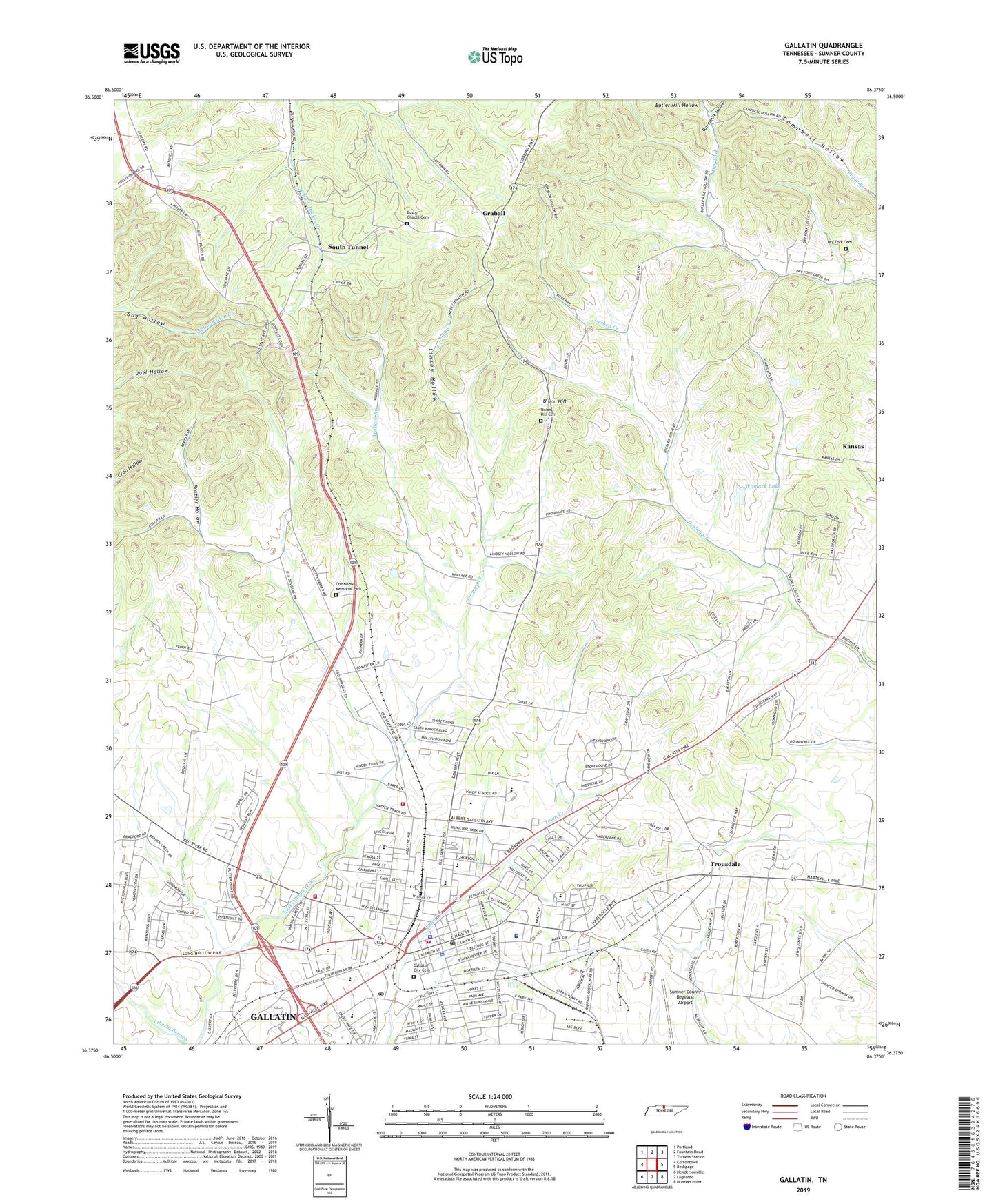
Gallatin Tennessee US Topo Map
Couldn't load pickup availability
2019 topographic map quadrangle Gallatin in the state of Tennessee. Scale: 1:24000. Based on the newly updated USGS 7.5' US Topo map series, this map is in the following counties: Sumner. The map contains contour data, water features, and other items you are used to seeing on USGS maps, but also has updated roads and other features. This is the next generation of topographic maps. Printed on high-quality waterproof paper with UV fade-resistant inks.
Quads adjacent to this one:
West: Cottontown
Northwest: Portland
North: Fountain Head
Northeast: Turners Station
East: Bethpage
Southeast: Hunters Point
South: Laguardo
Southwest: Hendersonville
Contains the following named places: Bradley Industrial Park, Brazier Hollow, Bushs Chapel Cemetery, Bushs Chapel Church of Christ, Bushs Chapel School, Butler Mill Hollow, Buttermilk Hollow, City of Gallatin, Clearview Park, College Heights Baptist Church, Commissioner District 5, Crestview Memorial Park, Depot Square Shopping Center, Dry Fork Cemetery, Dry Fork Church, First Baptist Church, First Call Ambulance Service Sumner, First Presbyterian Church, First United Methodist Church, Free Indeed Fellowship Church, Galaltin Post Office, Galatin Country Club, Gallatin, Gallatin City Cemetery, Gallatin City Hall, Gallatin City Park, Gallatin Community Volunteer Fire Department, Gallatin Division, Gallatin Fire Department Station 1, Gallatin Fire Department Station 3, Gallatin High School, Gallatin Middle School, Gallatin Police Department, Gallatin Post Office, Gallatin Stadium, Graball, Graball Census Designated Place, Green-Little Industrial Park, Highway 109 North Industrial Area, Howard College, Howard Elementary School, Howard School, Joe Shafer Middle School, Kansas, Key Church, Linsey Hollow, Long Hollow Golf Course, Mount Zion Church, Music City Executive Airport, Neophogen Male and Female College, Phosphate, Professional Medical Transportation, R T Fisher Alternative School, Salem Church, South Gate Shopping Center, South Tunnel, Steam Plant Road Industrial Area, Sumner County, Sumner County Ambulance Service, Sumner County Courthouse, Sumner County Fairgrounds, Sumner County Health Center, Sumner County Library, Sumner County Sheriff's Office, Sumner Regional Medical Center, Trousdale, Union Elementary School, Union Elementary Year Round School, Union High School, Union Hill, Union Hill Baptist Church, Union Hill Cemetery, Union Hill Church of Christ, Union Hill School, Union School, Vena Stuart Elementary School, Wallace Branch, WAMG-AM (Gallatin), WHIN-AM (Gallatin), Womack Lake, Womack Lake Dam, WVCP-FM (Gallatin), WWKX-FM (Gallatin), ZIP Code: 37066