
MyTopo
Denton East Texas US Topo Map
Couldn't load pickup availability
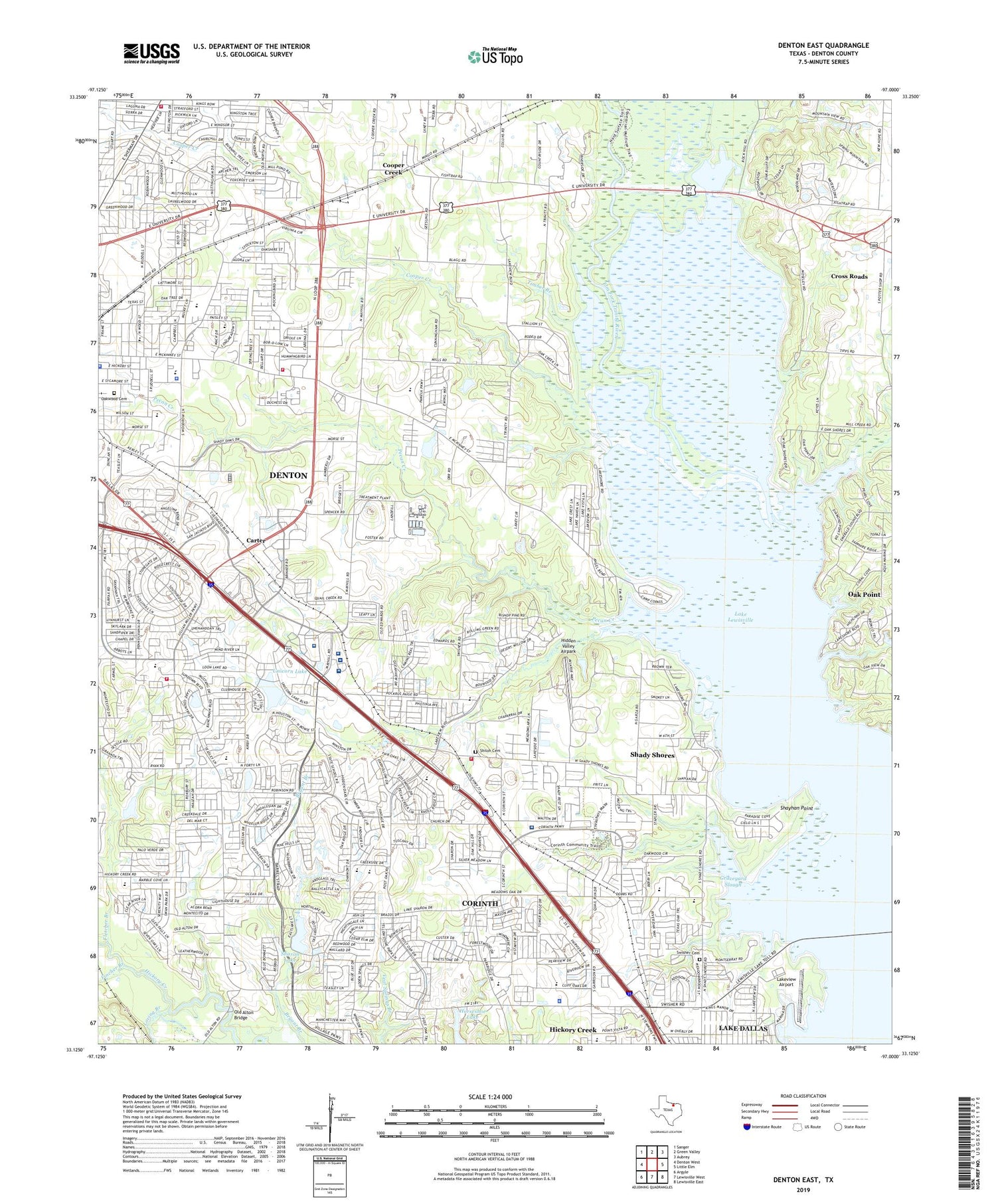
2019 topographic map quadrangle Denton East in the state of Texas. Scale: 1:24000. Based on the newly updated USGS 7.5' US Topo map series, this map is in the following counties: Denton. The map contains contour data, water features, and other items you are used to seeing on USGS maps, but also has updated roads and other features. This is the next generation of topographic maps. Printed on high-quality waterproof paper with UV fade-resistant inks.
Quads adjacent to this one:
West: Denton West
Northwest: Sanger
North: Green Valley
Northeast: Aubrey
East: Little Elm
Southeast: Lewisville East
South: Lewisville West
Southwest: Argyle
Contains the following named places: Atrium Medical Center, Betania Iglesia Bautista Church, Big Sandy Park, Billy Ryan High School, Camp Copass, Cantrell Slough, Carter, Christ the Servant Lutheran Church, City of Corinth, City of Lake Dallas, Cooper Creek, Corinth, Corinth Elementary School, Corinth First Baptist Church, Corinth Police Department, Cross Roads, Denton County, Denton County Sheriff's Office, Denton Fire Department Station 2, Denton Fire Department Station 4, Denton Fire Department Station 6, Denton Law Enforcement Center Denton County Jail, Denton Police Department, Denton Regional Medical Center, Denton School, Denton State School, Falcon Stadium, Fincher Branch, First Cumberland Presbyterian Church, First Mexican Baptist Church, Fish Trap Park, Fletcher Branch, Galbraith Lake Dam, Golden Triangle Post Office, Golden Triangle Shopping Center, Graveyard Slough, Hidden Valley Airpark, Hope Lutheran Church, Horseshoe Lake, Houston Elementary School, Integrity Transitional Hospital, Jefferson Davis School, John Knox Village Lake, John Knox Village Lake Dam, KDNT-AM (Denton), Lake Cities Fire Department Station 2, Lake Dallas High School, Lake Dallas Primary School, Lake Sharon Dam, Lakeview Airport, Loving Branch, Mack Park, May Hill School, Mayhill, Mayhill Hospital, Mckinneysaint Baptist Church, McNair Elementary School, Memorial Baptist Church, Mingo, Moore Park, Moore School, Mount Calvary Baptist Church, Oakwood Cemetery, Old Alton Baptist Church, Old Alton Bridge, Old Alton Church, Peaceful Rest Baptist Church, Pecan Creek, Phoenix Park, Pleasant Grove Baptist Church, Pleasant Grove Church, Prairie Saint Church of Christ, Rail Trail, Rivera Elementary School, Saint Emmanuel Missionary Baptist Church, Saint Mark Catholic Church, Schultz Park, Shady Shores, Shady Shores Baptist Church, Sharon Lake, Shayhan Point, Shiloh Cemetery, Singing Oaks Church of Christ, Skiles Park, Sky Ranch, Sullivan - Keller Early Childhood Center, Swisher Cemetery, Synod of the Sun Presbyterian Church, Texas Womans University Golf Course, The Church of Jesus Christ of Latter Day Saints, The Heart Hospital Baylor Denton, Timber Branch, Town of Shady Shores, Trinity United Methodist Church, Unicorn Lake, Upper Trinity Regional Water Treatment Facility, Wilson Elementary School, Woodrow Park, Woodrow Wilson School, ZIP Codes: 76208, 76209, 76210


