MyTopo
Kinsale Virginia US Topo Map
Couldn't load pickup availability
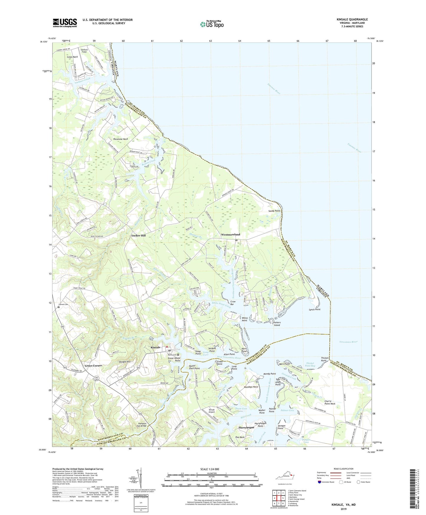
2019 topographic map quadrangle Kinsale in the state of Virginia. Scale: 1:24000. Based on the newly updated USGS 7.5' US Topo map series, this map is in the following counties: Westmoreland, St. Mary's, Northumberland. The map contains contour data, water features, and other items you are used to seeing on USGS maps, but also has updated roads and other features. This is the next generation of topographic maps. Printed on high-quality waterproof paper with UV fade-resistant inks.
Quads adjacent to this one:
West: Machodoc
Northwest: Saint Clements Island
North: Piney Point
Northeast: Saint Marys City
East: Saint George Island
Southeast: Heathsville
South: Lottsburg
Southwest: Haynesville
Contains the following named places: Allen Point, Askins Shop, Bailey Cemetery, Barn Point, Barn Point Light, Bonum Creek, Carmel Church, Carmel United Methodist Church Cemetery, Carys Corner, Cedar Point, Cherry Grove Creek, Cherry Grove Pond, Cherry Point Neck, Cople District Volunteer Fire Department Engine Company 3, Cornish Creek, Crow Bar, Devils Corner, Drum Cove, Dungan Cove, Dungan Point, Fauntleroy Farm, Gardner Creek, Gardy Millpond, Gardy Millpond Dam, Gardys Mill, Grays Corner, Great House Point, Hampton Hall Branch, Hampton Hall Bridge, Hampton Hall Creek Landing, Harryhogan, Harryhogan Point, Horn Point, Hudsons Landing, Jackson Creek, Kinsale, Kinsale Branch, Kinsale Fork, Kinsale Methodist Church, Kinsale Post Office, Lodge Creek, Long Cove, Long Point, Lynch Point, Mill Creek, Mondays Neck, Morrisons Corner, Mundy Point, New Jerusalem Church, Northwest Yeocomico River, Oyster Shell Point, Palmer Cove, Palmer Point, Parkers Creek, Parkers Island, Pea Neck, Pecatone Neck, Sandy Point, Sandy Point Post Office, Sanford Field, Seldom Point, Shady Harbor Shores, Shannon Branch, Shingle Hill, Shivok Airport, Sloop Point, South Yeocomico River, Thicket Point, Thicket Point Bay, Thompson Mill, Thompson Millpond, Tom Jones Point, Tucker Hill, Vault Field Vineyards, Walker Point, West Yeocomico River, Westmoreland, Wheatland Turn, White Point, White Point Creek, Wilkins Creek, Yeocomico Chapel, Yeocomico Church, Yeocomico River, Zion Church, ZIP Code: 22488