MyTopo
Machodoc Virginia US Topo Map
Couldn't load pickup availability
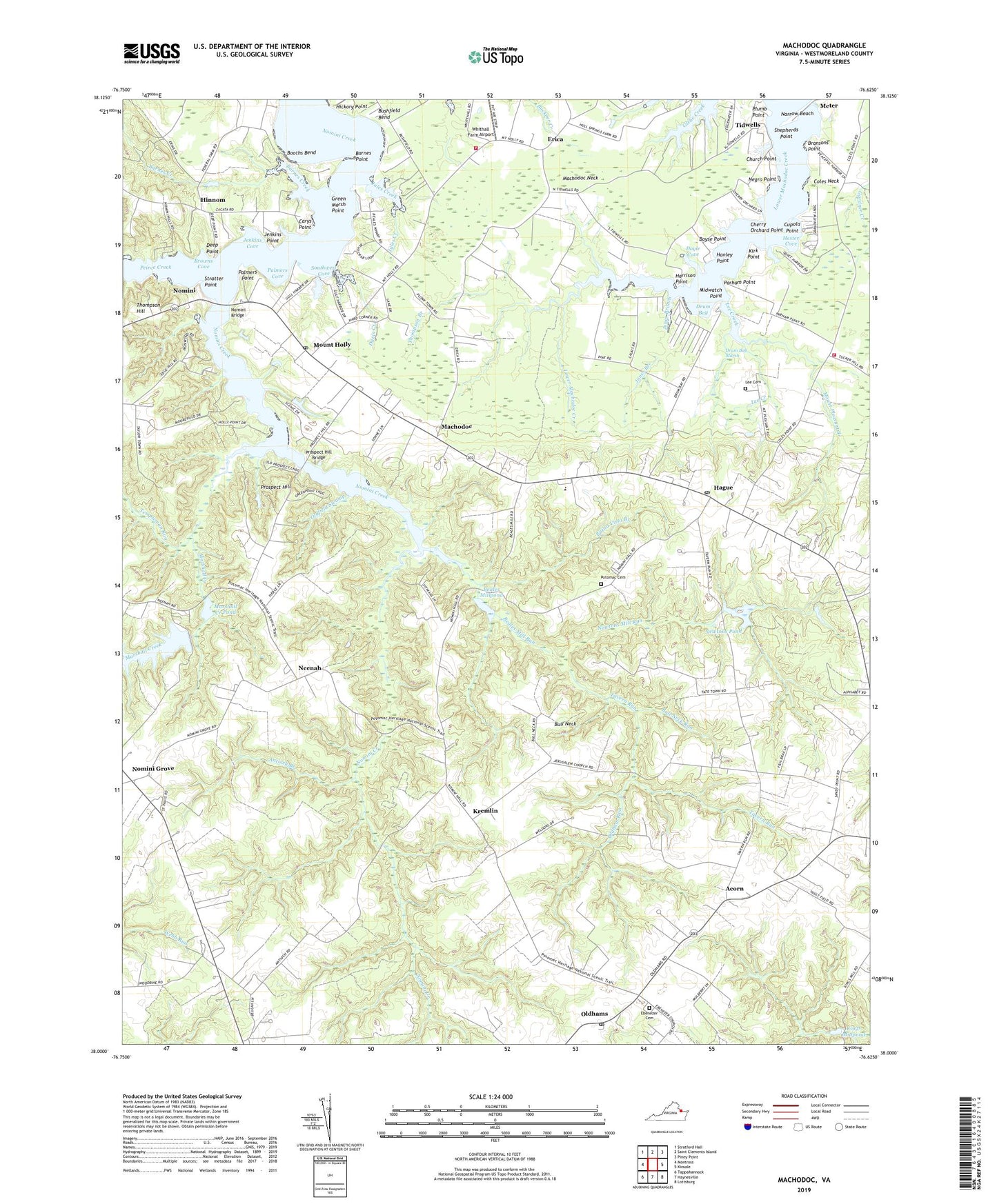
2022 topographic map quadrangle Machodoc in the state of Virginia. Scale: 1:24000. Based on the newly updated USGS 7.5' US Topo map series, this map is in the following counties: Westmoreland. The map contains contour data, water features, and other items you are used to seeing on USGS maps, but also has updated roads and other features. This is the next generation of topographic maps. Printed on high-quality waterproof paper with UV fade-resistant inks.
Quads adjacent to this one:
West: Montross
Northwest: Stratford Hall
North: Saint Clements Island
Northeast: Piney Point
East: Kinsale
Southeast: Lottsburg
South: Haynesville
Southwest: Tappahannock
This map covers the same area as the classic USGS quad with code o38076a6.
Contains the following named places: Acorn, Antioch Branch, Antioch Farm, Barnes Creek, Barnes Point, Bayside, Beales Mill, Beales Mill Run, Beales Millpond, Beales Wharf, Bible Way Church, Booths Bend, Boyse Point, Bransons Point, Browns Cove, Buena Vista Branch, Bull Neck, Bull Neck Run, Burnt House Field - Lee Family Cemetery, Bushfield Bend, Camp Hull Springs, Carys Point, Cherry Orchard Point, Church Point, Coles Point United Methodist Church, Cople Chapel, Cople District, Cople District Volunteer Fire Department Engine Company 32 - Coles Point Substation, Cople Elementary School, Cupola Point, Davis Creek, Deep Point, Deep Point Landing, Deep Point-Mount Holly Ferry, Doyle Cove, Drum Bay, Drum Bay Marsh, Ebenezer Church, Ebenezer United Methodist Church Cemetery, Edgewater Church, Elba School, Erica, Green Marsh Point, Griffiths Corner, Hague, Hague Post Office, Hanley Point, Harrison Point, Hester Cove, Hickory Point, Hinnom, Hinnom Post Office, Howells Fork, Jenkins Cove, Jenkins Point, Jerusalem Church, Jones Branch, Jules Creek, Kings Millpond, Kinsale Fire Department Meeting Hall, Kirk Point, Knights Community Hall, Kremlin, Kremlin School, Lee Creek, Machodoc, Machodoc Neck, Marshall Creek, Marshall Creek Dam, Marshall Creek Pond, McGuires Wharf, Midwatch Point, Morning Star Church, Mount Holly, Mount Holly Post Office, Mount Olive Church, Mount Pleasant Branch, Mount Pleasant Farm, Mount Pleasant Plantation, Narrow Beach, Neenah, Negro Point, Newtons Dam, Newtons Mill, Newtons Mill Run, Newtons Pond, Nomini, Nomini Bridge, Nomini Church, Nomini Ferry, Nomini Grove, Nomini Hall, Oldfield Swamp, Oldham Run, Oldhams, Oldhams Post Office, Palmers Cove, Palmers Point, Palmtown, Parham Point, Peirce Creek, Plumb Point, Potomac Baptist Church Cemetery, Potomac Church, Potomac School, Prospect Creek, Prospect Hill, Prospect Hill Bridge, Saint James Church, Saint Johns Church, Saint Pauls Church, Salem Church, Salem School, Shepherds Point, Shorts Store, Southwest Cove, Stratter Point, Tavern Millpond, Tavern Run, Templeman Run, Thompson Branch, Thompson Hill, Tidwells, Tidwells School, Westmoreland Lookout Tower, Westmoreland Volunteer Fire Department Engine Company 5, Westmoreland Volunteer Rescue Squad, Whithall Farm Airport, Woodland Academy, ZIP Codes: 22469, 22529