MyTopo
Vansant Virginia US Topo Map
Couldn't load pickup availability
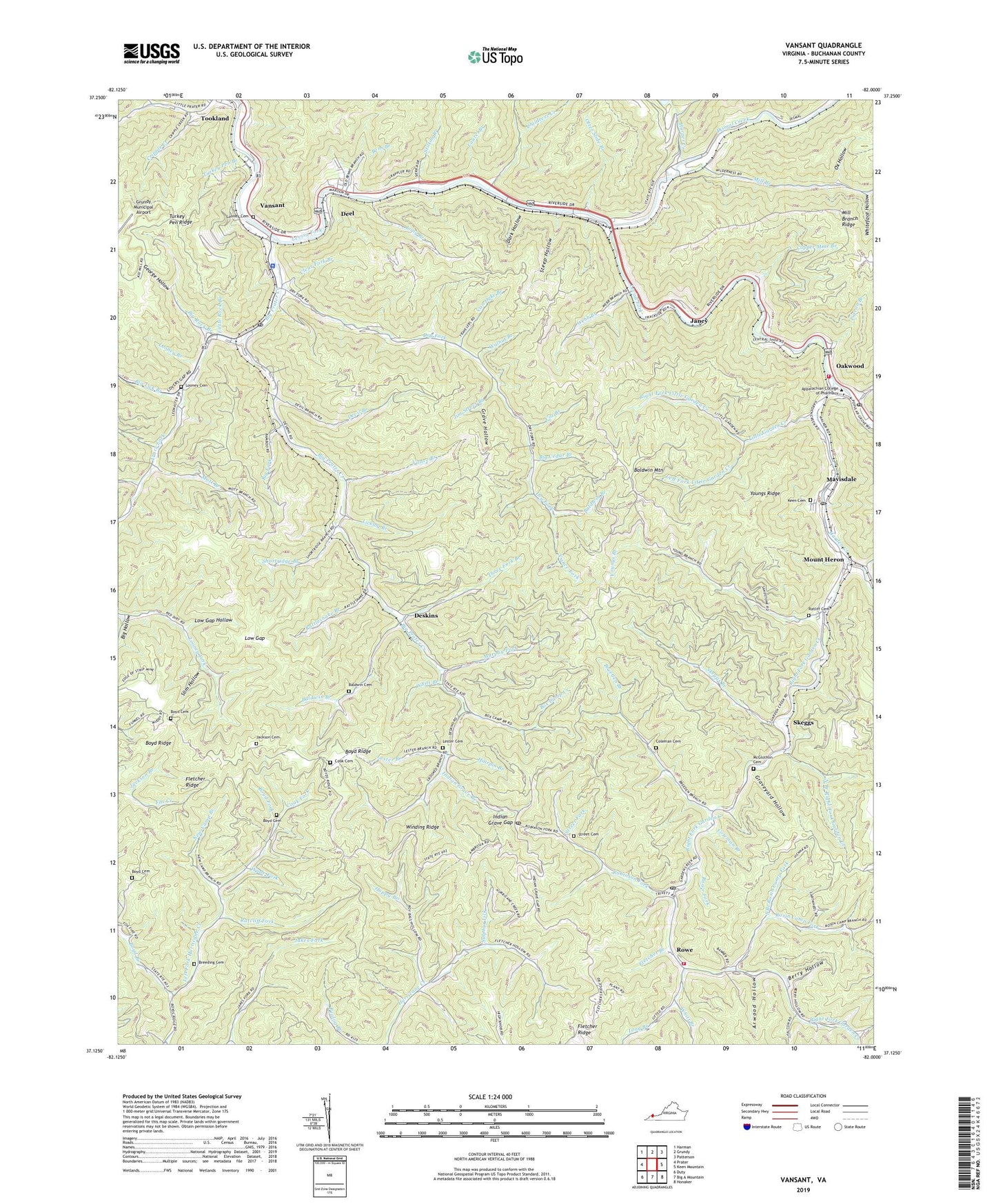
2019 topographic map quadrangle Vansant in the state of Virginia. Scale: 1:24000. Based on the newly updated USGS 7.5' US Topo map series, this map is in the following counties: Buchanan. The map contains contour data, water features, and other items you are used to seeing on USGS maps, but also has updated roads and other features. This is the next generation of topographic maps. Printed on high-quality waterproof paper with UV fade-resistant inks.
Quads adjacent to this one:
West: Prater
Northwest: Harman
North: Grundy
Northeast: Patterson
East: Keen Mountain
Southeast: Honaker
South: Big A Mountain
Southwest: Duty
Contains the following named places: Arwood Hollow, Baldwin Branch, Baldwin Cemetery, Baldwin Mountain, Bens Branch, Berry Hollow, Big Cedar Branch, Big Fork, Big Hollow, Big Lick Branch, Big Prater Creek, Big Rock Branch, Box Branch, Box Camp Creek, Boyd Branch, Boyd Cemetery, Boyd Fork, Boyd Ridge, Boyd School, Breeden Branch, Breeding Cemetery, Breeding Chapel, Childress Creek, Clear Fork Branch, Coleman Branch, Coleman Cemetery, Cook Cemetery, Cook Fork, Copper Mine Branch, Cox Branch, Cripple Creek, Crooked Branch, Dark Hollow, Deel, Deskins, Deskins Church, Devil Branch, Dismal Creek, Dry Fork, Fletcher Branch, Fletcher Church, Fletcher Ridge, Garden Creek, Garden Creek Church, Garden High School, Garden Mission Church, Garden School, George Hollow, Grave Hollow, Graveyard Hollow, Guiding Light Church, Hairpin Branch, Hanger, Happy Branch, Harper Creek, Indian Gap Post Office, Indian Grave Branch, Indian Grave Gap, Jackson Branch, Jackson Cemetery, Janey, Jerusalem Church, Jim Street Branch, Keen Cemetery, Kennel Branch, Laurel Branch, Left Fork Little Garden Creek, Lester Branch, Lester Cemetery, Licklog Branch, Little Garden Creek, Little Prater School, Little Rock Branch, Long Branch, Looney Branch, Looney Cemetery, Looney Chapel, Low Gap, Low Gap Hollow, Matney Branch, Mavisdale, Mavisdale Post Office, McGlothlin Cemetery, Mill Branch, Mill Branch Ridge, Moody Branch, Mott Branch, Mount Heron, Murphy Fork, New Camp Branch, North Branch Right Fork Garden Creek, Oakwood, Oakwood Post Office, Oakwood Volunteer Fire Department Station 1, Oakwood Volunteer Fire Department Station 2, Otter Slide Branch, Ox Hollow, Pigeon Branch, Quillen School, Ratcliff Chapel, Ratcliff Fork, Ratliff Cemetery, Rattlesnake Branch, Right Fork Garden Creek, Right Fork Little Garden Creek, Robinson Fork, Rosin Camp Fork, Rowe, Rowe Fork, Rowe Post Office, Sad Branch, Shortridge Branch, Skeggs, Skeggs Branch, Slim Hollow, South Branch Rosin Camp Fork, South Grundy District, Stagger Branch, Steep Hollow, Stilton Branch, Street Cemetery, Street Fork, Street School, Sulphur Lick, Three Fork Branch, Trace Fork, Triangular Mountain Institute, Turkey Pen Branch, Turkey Pen Ridge, Twin Valley Elementary and Middle School, Van Dyke Branch, Vance Branch, Vance Fork, Vansant, Vansant Census Designated Place, Vansant Elementary School, Vansant Post Office, Virginia State Police Division 4 Area 29 Office, Wade Fork, Wade Ratliff School, Walnut Branch, Webb Branch, Weeks Hollow, Whiteface Hollow, Whitt Branch, Winding Ridge, Youngs Branch, Youngs Ridge, ZIP Codes: 24646, 24656