
MyTopo
Anacortes South Washington US Topo Map
Couldn't load pickup availability
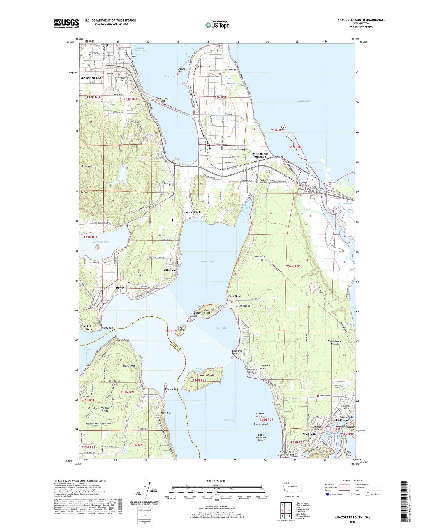
2020 topographic map quadrangle Anacortes South in the state of Washington. Scale: 1:24000. Based on the newly updated USGS 7.5' US Topo map series, this map is in the following counties: Skagit, Island. The map contains contour data, water features, and other items you are used to seeing on USGS maps, but also has updated roads and other features. This is the next generation of topographic maps. Printed on high-quality waterproof paper with UV fade-resistant inks.
Quads adjacent to this one:
West: Deception Pass
Northwest: Cypress Island
North: Anacortes North
Northeast: Bow
East: La Conner
Southeast: Utsalady
South: Crescent Harbor
Southwest: Oak Harbor
Contains the following named places: Anacortes Fire Department, Anacortes First Baptist Church, ASC Sand and Gravel Quarry, Becker's Landing, Ben Ure Spit, Blind Slough, City of Anacortes, Crandall Spit, Deadman Island, Deception Pass, Deception Pass State Park Marina, Dewey, Fern Hill Cemetery, Fidalgo, Fidalgo Bay, Fidalgo Elementary School, Fidalgo Marina, First Assembly of God Church, Flagstaff Point, Fort Knox Mobile Home Park, Galliher Point, Gibraltar, Gibralter Landfill, Grand View Cemetery, Hope Island, Howards Corner, Hoypus Hill, Hoypus Point, Indian Shaker Church, John Storvik Playground, Kiket Bay, Kiket Island, KLKI-AM (Anacortes), La Conner Neighborhood Church, Lake Campbell, Lang Bay, Learning Opportunity Center, Little Deadman Island, Lone Tree Point, March Point, March Point Landfill, March's Point Park and Ride, Marthas Bay, Mount Erie Elementary School, Mount Erie Park, New Hope Christian Fellowship Church, Old Channel, Pilgrim Congregational Church, Pioneer Park, Pioneer Point Marina, Pull and Be Damned Point, Rainbow Bridge, Saint Mary's Catholic Church, Saint Marys School, Saint Paul Catholic Church, Sharpes Corner, Shelter Bay, Shelter Bay Census Designated Place, Shelter Bay Marina, Shelter Bay Tribal Sewer District Water Treatment Facility, Similk Bay, Similk Beach, Similk Golf Course, Skagit County Fire District 11 Mount Erie Volunteer Fire Department Station 1, Skagit County Fire District 13 Station 1 Summit Park Volunteer Fire Department, Skagit County Fire District 13 Station 2 Hope Island Volunteer Fire Department, Skagit Island, Snee Oosh, Snee-oosh Beach, Snee-oosh Point, Summit Park, Summit Park Bible Church, Swinomish Cemetery, Swinomish Channel, Swinomish Police Department, Swinomish Reservation, Swinomish Reservation Division, Swinomish Village, Tonkon Islands, Troxel Hill, Turners Bay, Twin Bridges Marina, Weaverling Spit, West Shore, Whistle Lake, Whitmarsh Junction, Yokeko Point, ZIP Code: 98257


