MyTopo
Marysville Washington US Topo Map
Couldn't load pickup availability
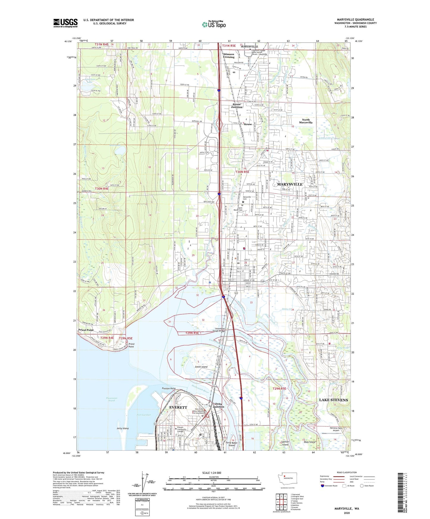
2020 topographic map quadrangle Marysville in the state of Washington. Scale: 1:24000. Based on the newly updated USGS 7.5' US Topo map series, this map is in the following counties: Snohomish. The map contains contour data, water features, and other items you are used to seeing on USGS maps, but also has updated roads and other features. This is the next generation of topographic maps. Printed on high-quality waterproof paper with UV fade-resistant inks.
Quads adjacent to this one:
West: Tulalip
Northwest: Stanwood
North: Arlington West
Northeast: Arlington East
East: Lake Stevens
Southeast: Snohomish
South: Everett
Southwest: Mukilteo
Contains the following named places: 10th Street School, 98201, 98270, 98271, Albertsons Shopping Center, Allen Creek, Allen Creek Community Church, Allen Creek Elementary School, American Legion Memorial Park, Aspen, Assembly of God Church of Marysville, Bailey African Methodist Episcopal Church, Battle Creek Golf Course, Bethlehem Christian School, Bethlehem Lutheran Church, Bethlehem Lutheran Church Preschool, Boeing Fire Department Tulalip, Boeing-Tulalip Heliport, Broadway Terrace Mobile Home Park, Brookside Mobile Home Park, Brookside Mobile Recreational Vehicle Park, Cascade Christian Reformed Church, Cascade Elementary School, Cedar Crest Golf Course, Cedar Lane Mobile Home Park, Cedarcrest Middle School, Charles Denny Juvenile Detention Center School, Charles R Denney Juvenile Justice Center, City of Marysville, College Plaza Shopping Center, Columbia College Naval Station Everett / Marysville, Consolidated Borough Of Quil Ceda Village, Country Mobile Estates, Dagmars Marina, Dagmars Yacht Club, Delta Junction, Delta Substation, Ebey Slough, Everett Community College, Everett Plaza Assisted Living Community, Everett Trailer Court, Evergreen Unitarian Universalist Fellowship Church, Ferry Baker Island, Fire Trail Census Designated Place, First Baptist Church, Geddes Marina, Glenwood Mobile Estates, Grace Academy, Grace Bible Church, Grandview Village Retirement Community, Grove Elementary School, Hawthorne Elementary School, Hayho Creek, Heineck Farm Airport, Jetty Island, John Sam Lake, John Sam Lake Census Designated Place, Jones Creek, Jubilee Church of God in Christ, Judah Praise Center, Kellogg Marsh Elementary School, Kellogg Marsh Grange, Kellogg Village Mobile Home Park, Ken Baxter Senior Community Center, King Creek, King Pond, Kingdom Hall of Jehovahs Witnesses, Kruse, Kruse Junction, La Tierra Mobile Home Park, Lake Stevens Sewage Treatment Plant, Legacy School, Liberty Elementary School, Liberty Village Mobile Home Park, Little Coho Creek, Madeleine Villa Health Care Center, Maplewood, Maplewood Census Designated Place, Marshall, Marshall Elementary School, Marysville, Marysville Alternative High School, Marysville Ash Avenue Park and Ride, Marysville Care Center, Marysville Carrier Annex Post Office, Marysville Cemetery, Marysville Christian Church, Marysville Christian School, Marysville City Hall, Marysville Cooperative Program School, Marysville Detention Center, Marysville Division, Marysville Fire District Station 61, Marysville Fire District Station 62 Shoultes, Marysville Fire District Station 66 Sunnyside, Marysville Free Methodist Church, Marysville I Park and Ride, Marysville II Park and Ride, Marysville Junior High School, Marysville Library, Marysville Middle School, Marysville Municipal Court, Marysville Pilchuck High School, Marysville Police Department, Marysville Post Office, Marysville Public Works, Marysville Receiver Site, Marysville School District 25 Office, Marysville Seventh Day Adventist Church, Marysville Sewage Lagoon, Marysville Sewage Treatment Plant, Marysville United Methodist Church, Marysville West, Maryville Fred Meyer, Master's Touch Christian School, Merrill Gardens at Marysville, Messiah Lutheran Church, Messiah Lutheran Preschool, Middle Fork Quilceda Creek, Mobile Haven Mobile Home Park, Mobile Manor, Mountain View Presbyterian Church, Munson Creek, Neff Farms, Ninety - Second Street Church of Christ, North Country Chapel, North Marysville, North Marysville Census Designated Place, Northwest Ambulance Critical Care Transport, Northwest Baptist Church, Pine Street Mobile Home Park, Pinewood Elementary School, Port of Everett, Preston Point, Priest Point, Priest Point Census Designated Place, Priest Point Grange, Quil Ceda Census Designated Place, Quil Ceda Elementary School, Quil Ceda Substation, Quilceda, Quilceda Creek, Rainwater, Ross Lake, Saint Mary's Catholic Church, Saint Mary's Cemetery, Saint Philip's Episcopal Church, Sands 55 Plus Mobile Park, Schons Family Dairy Farm, Seacrest Marina, Shaker Church, Shaker Church Census Designated Place, Shoultes Elementary School, Shoultes Gospel Hall, Smith Island, Sno - Isle Libraries Service Center Administrative Offices, Snohomish River, Snug Harbor Mobile Home Park, Steamboat Slough, Steamboat Slough Bridge, Stimson, Stimson Crossing, Stimson Crossing Census Designated Place, Sturgeon Creek, Sunnyside Elementary School, Tenth Street School, Tenth Street Substation, The Church of Jesus Christ of Latter Day Saints, Totem Middle School, Town Center Mall, Tulalip Church of God, Tulalip Learning Center, Tulalip Substation, Twin Cedar Mobile Park, Union Slough, Victory Foursquare Gospel Church, View Crest Abbey Mausoleum and Columbarium, Washington State Patrol - District 7 Headquarters, West Fork Quilceda Creek, Western Washington Indian Agency, Whittier Elementary School, Woodinville Town Center, Word of Life Lutheran Brethren Church