MyTopo
Snohomish Washington US Topo Map
Couldn't load pickup availability
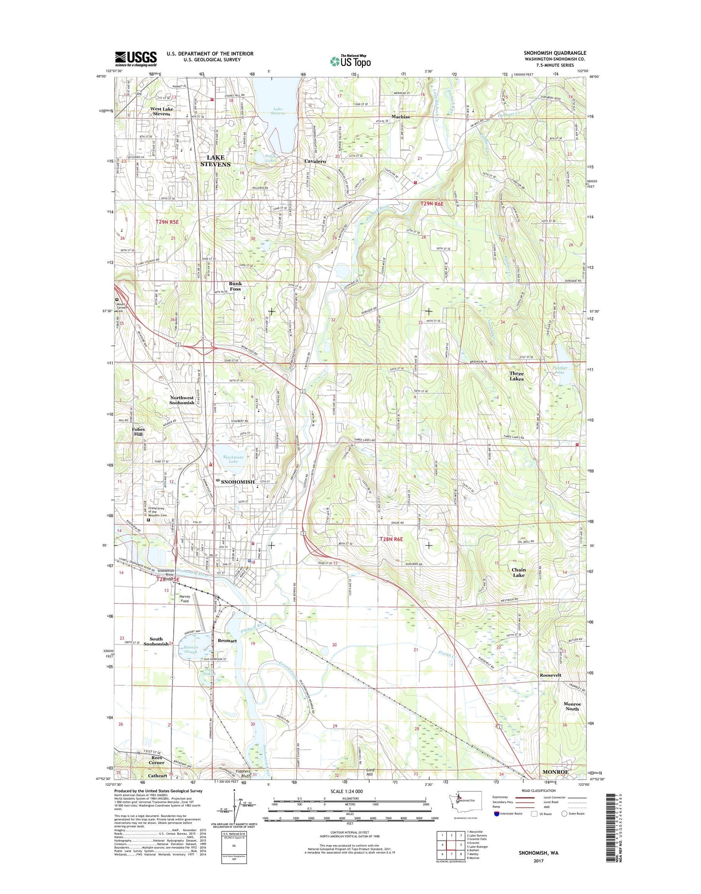
2020 topographic map quadrangle Snohomish in the state of Washington. Scale: 1:24000. Based on the newly updated USGS 7.5' US Topo map series, this map is in the following counties: Snohomish. The map contains contour data, water features, and other items you are used to seeing on USGS maps, but also has updated roads and other features. This is the next generation of topographic maps. Printed on high-quality waterproof paper with UV fade-resistant inks.
Quads adjacent to this one:
West: Everett
Northwest: Marysville
North: Lake Stevens
Northeast: Granite Falls
East: Lake Roesiger
Southeast: Monroe
South: Maltby
Southwest: Bothell
Contains the following named places: Aim High School, Alternative Middle School, Antique Rose Farm, Antique Rose Farm Museum, Bailand Farms, Batt Slough, Blackman House, Blackmans Lake, Bromart, Bueler Farms, Bunk Foss Census Designated Place, Cardinal Estates Mobile Home Park, Cascade View Elementary School, Cavalero Census Designated Place, Cavelero Middle High School, Centennial Middle School, Central Elementary School, Christ the King Lutheran Church, Circle H Mobile Home Park, City of Snohomish, Clearview Montessori School, Country Dawn Kindergarten Center, Country Dawn Preschool, Country Village Center, Crawdad Creek, Delta Rehabilitation Center, Diamond M Farms, Dubuque Creek, Dutch Hill Elementary School, Emerson Elementary School, Ferguson Cottage, Ferguson Park, First Step Learning Center, Fobes Hill, French Creek, Freshman Campus Re Entry School, Frontier Manor Mobile Home Park, Frontier Substation, Glenwood Elementary School, Goodrich Mobile Park, Grand Army of the Republic Cemetery, Greentree Plaza Shopping Center, Hanson Slough, Harvey Field, Hillcrest Elementary School, Holy Cross Lutheran Church, Jamison Corner, Kids N Us Child Care Center Lake Stevens, Lake Country Baptist Church, Lake Stevens Fire Department Station 82, Lake Stevens Landfill, Lake Stevens Middle School, Lake Stevens Substation, Lake Stevens Transit Center, Lake Stevens Transit Center Park and Ride, Lakeview Chapel, Lakeview Elementary School, Lakeview Mobile Home Park, Lamb of God Luthern Church, Little Pilchuck Creek, Lobo Golf Course, Lord Hill, Machias, Machias Census Designated Place, Machias Community Cemetery, Machias Elementary School, Machias Mobile Manor, Merry Haven Care Center, Mill Creek Center Shopping Center, Mount Carmel Cemetery, Mount View Villa Mobile Home Park, Northwest Snohomish Census Designated Place, Panther Creek, Panther Creek Chlorination Station, Panther Lake, Parkpointe Plaza, Peaceful Glen Christian School, Penny Lynn Mobile Home Park, Pilchuck Mobile Park, Pilchuck River, Plantation Mobile Home Park, Pleasant View Ranch, Rees Corner, Reflection Creek, Romberger Farms, Roosevelt, Saint Michael Catholic Church, Saint Michael Catholic School, Scott Creek, Skyline Elementary School, Snohomish, Snohomish City Hall, Snohomish County Fire District 4 Station 41, Snohomish County Fire District 4 Station 42, Snohomish County Fire District 4 Station 43 Headquarters, Snohomish County Fire Protection District 8 Fire Station 3, Snohomish Division, Snohomish Freshman Campus Middle School, Snohomish Golf Course, Snohomish High School, Snohomish Library, Snohomish Mobile Home Park, Snohomish Park and Ride, Snohomish Police Department, Snohomish Post Office, Snohomish Recreational Vehicle Park, Snohomish River Bridge, Snohomish School District 201 Office, Snohomish Shopping Center, Snohomish Substation, Snohomish Wastewater Treatment Plant, Soapsuds Row, South Snohomish, Stitch Lake, Sunrise of Snohomish Senior Living Facility, The Church of Jesus Christ of Latter Day Saints, Three Lakes, Three Lakes Substation, Wares Machias Flight Park, West Lake Stevens, West Lake Stevens Census Designated Place, Zion Lutheran Cemetery, Zion Lutheran School