MyTopo
Clendenin West Virginia US Topo Map
Couldn't load pickup availability
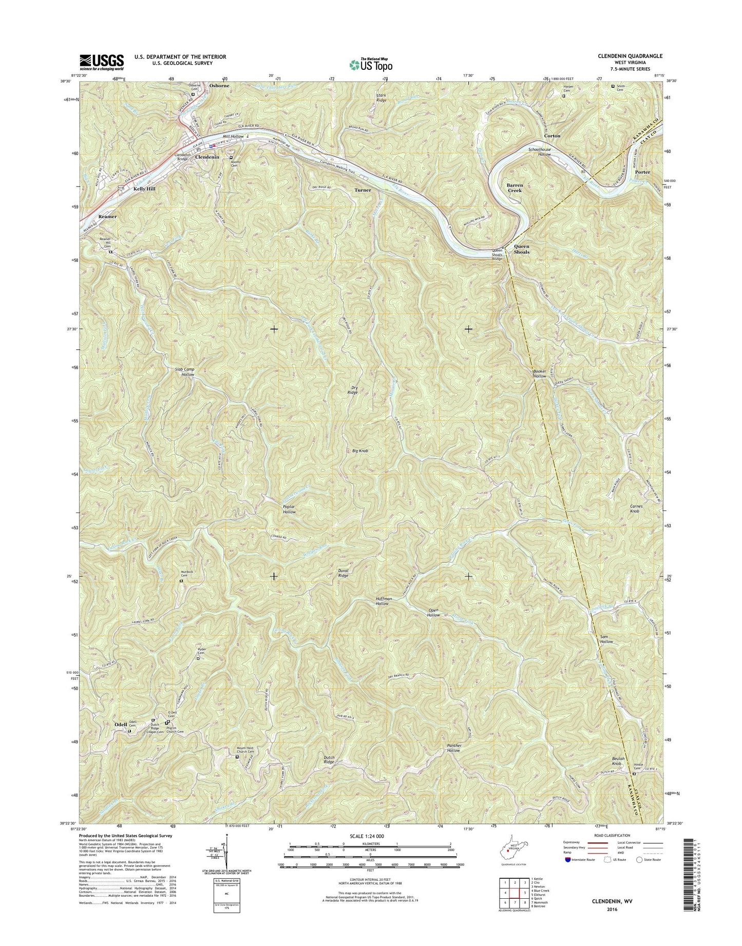
2019 topographic map quadrangle Clendenin in the state of West Virginia. Scale: 1:24000. Based on the newly updated USGS 7.5' US Topo map series, this map is in the following counties: Kanawha, Clay. The map contains contour data, water features, and other items you are used to seeing on USGS maps, but also has updated roads and other features. This is the next generation of topographic maps. Printed on high-quality waterproof paper with UV fade-resistant inks.
Quads adjacent to this one:
West: Blue Creek
Northwest: Kettle
North: Clio
Northeast: Newton
East: Elkhurst
Southeast: Bentree
South: Mammoth
Southwest: Quick
Contains the following named places: Apgah, Barren Creek, Beulah Knob, Big Creek, Big Knob, Big Sandy Creek, Blessed Hope Church, Blue Creek Academy, Booker Hollow, Brawley Church, Broad Run, Burke Branch, Camp Wheelgate, Carnes Knob, Clendenin, Clendenin Branch Library, Clendenin Bridge, Clendenin Elementary School, Clendenin First Baptist Church, Clendenin Middle School, Clendenin Police Department, Clendenin Post Office, Clendenin Volunteer Fire Department, Cold Spring School, Corton, Corton Post Office, Dry Ridge, Dry Ridge School, Dutch Ridge, Dutch Ridge Chapel, Dutch Ridge Chapel Cemetery, Duval Ridge, Eds Fork, Eds Fork School, Evans Fork, Gazil, Grasslick Branch, Harper Cemetery, Harts Branch, Heatherman, Hinkle Cemetery, Horse Fork, Huffman Hollow, Johnson Fork, Kanawha County Emergency Ambulance Authority Station 19, Kelly Hill, Koontz Cemetery, Laurel Branch, Left Fork Leatherwood Creek, Left Fork Queen Shoals Creek, Malcolm Fork, Mill Hollow, Morris Creek, Morris Creek Wildlife Management Area, Mount Haid Church, Mount Haid Church Cemetery, Mudlick Fork, Murdock Cemetery, O Dell Cemetery, Oakhill School, Odell, O'Dell Cemetery, Odell School, Open Hollow, Osborne, Osborne Cemetery, Oxyer Branch, Petes Fork, Pilgrim Church, Pilgrim Church Cemetery, Poplar Hollow, Porter, Porter Creek, Pups Creek, Queen Shoals, Queen Shoals Bridge, Queen Shoals Creek, Reamer, Reamer Hill Cemetery, Reamer Hill Church, Reamer Hill School, Rosina, Ryder Cemetery, Sam Hollow, Sand Branch, Schoolhouse Hollow, Slab Camp Hollow, Smith Cemetery, Town of Clendenin, Turkey Fork, Turner, Turner School, Valley View School, Vent Fork, Wolfpen Run, Youngs Memorial Chapel, ZIP Code: 25045