MyTopo
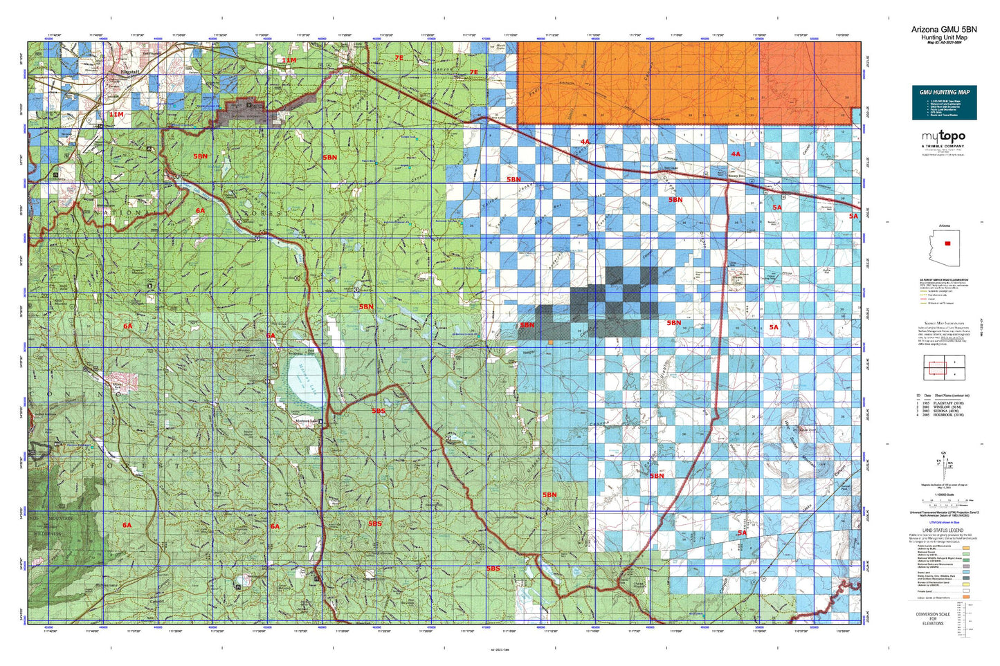
Arizona GMU 5BN Map
Couldn't load pickup availability
Hunting unit map of Arizona Game Management Unit 5BN with topographic lines and unit boundaries. This topo map features UTM / MGRS and Latitude/Longitude grids, plus public land ownership. It comes folded on waterproof paper. Be fully prepared for your hunt with a MyTopo GMU map!.
This map contains the following named places: 86017,86038,A B Young Trail,Allan Lake Landing,Als Lake,Anderson Canyon,Anderson Draw,Anderson Mesa,Antelope Lake,Ashurst Lake,Ashurst Lake Boat Launch,Ashurst Lake Campground,Ashurst Lake Dam,Ashurst Run,Banjo Bill Campground,Bar M Canyon,Bass Point,Bear Wallow Canyon,Bee Canyon,Big Park,Billy Back Draw,Boot Lake,Bootlegger Campground,Bow and Arrow Park,Breezy Lake,Bridle Trail,Broomy Valley,Cabin Draw,Canyon Diablo,Canyon Diablo Dam,Canyon Diablo Reservoir,Canyon Vista Campground,Casner Canyon,Casner Canyon Eleven Trail,Cave Spring Campground,Cedar Dam,Cedar Tank Canyon,Chavez Pass Ditch,Cherry Canyon,Coconino County Fairgrounds,Coconino Dam,Coconino Lake,Coconino National Forest,Cookstove Draw,Corner Lake,Coulter Cabin,Coulter Hill,Coulter Mountain,Coulter Ridge,Courthouse Butte,Cow Hill,Cow Lake,Coyote Basin,Coyote Basin Ranch,Crater Lake,Crazy Park Canyon,Crusher Sink,Dairy Springs Campground,Damfino Canyon,Deep Lake,Devils Dining Room,Diversion Dam,Dog Valley,Double Springs Campground,Ducksnest Lake,Encinoso Picnic Area,Fain Mountain,First Bench of Wilson Mountain,Fisher and Fry Lake,Fisher Point,Flagstaff Airport Business Center,Flagstaff Division,Flying M Ranch,Forest Highlands Golf Club,Forked Pine Campground,Forked Pine Picnic Area,Fort Tuthill,Fort Tuthill County Park,Foster Ranch,Foxboro Lake,Foxboro Lake Dam,Foxboro Ranch,Gash Mountain,Gorton Dam,Grasshopper Point,Grasshopper Point Campground,Halfway Picnic Area,Hoels Wash,Horse Lake,Horse Mesa,Hot Loop Trail,Howard Mountain,Hutch Mountain,Indian Gardens,Indian Lake,Indian Point,Jack Canyon-Munds Mountain Fifty Five - Seventy Seven,Jacks Point,Jaycox Mountain,Kachina Village,Kelly Pocket,Kinnikinick Campground,Kinnikinick Dam,Kinnikinick Lake,Kinnikinick Lake Boat Launch,K-T Ranch,Lake Mary Boating Site,Lake Mountain,Lake Number One,Lake View Campground,Lake View Forest Camp,Lakeview,Lee Butte,Lee Mountain,Lindbergh Spring Roadside Park,Little Dry Lake,Long Lake,Long Lake North Boat Launch,Long Lake South Boat Launch,Lower Lake Mary,Lower Lake Mary Dam,Lower Lake Mary Picnic Area,Luke Mountain,Mahan Mountain,Mahan Ranch,Manzanita Campground,Marshall Lake,McDermit Lake,Melbourne Dam,Merry-Go-Round,Meteor Crater Ranch,Meteor Crater Rest Area,Mexican Pocket,Midgely Bridge Picnic Area,Milos Butte,Mormon Lake,Mormon Lake Ranger District,Mormon Mountain,Mormon Ranger Station,Mortgage Tank,Morton Dam,Morton Lake,Mount Nestor,Mountainaire,Mud Lake,Munds Mountain,Munds Mountain Wilderness,Munds Park,Munds Park Rest Area,Munds Park Substation,Narrows Boat Launch,Newman Park,Oak Creek Canyon,Oak Creek Vista,Oak Creek Vista Campground,Oakwood Country Club,Odell Dam,Odell Lake,Perry Lake,Petes Water Haul,Pickett Lake,Pilgrim Playground,Pine Canyon Club,Pine Flat Campground,Pine Grove Camp and Picnic Grounds,Pine Grove Campground,Pine Grove Hill,Pine Hill,Pine Lake,Pinewood Country Club,Post Lake,Potato Lake,Potato Patch Park,Pratt Tank,Prime Lake,Pumphouse Wash,Quarry Sink,Rainbow Trailer Park,Rancho Sedona Recreational Vehicle Park,Raymond Park,Red Hill,Red Lake,Rimmy Jims,Ritter Butte,Ritter Mountain,Robbers Roost,Rock Top,Rockledge,Saginaw Sink,Saint Joseph Youth Camp,Santa Fe Dam,Sawmill Hills,Sawmill Wash,Schnebly Hill,Schnebly Hill Vista,School House Picnic Ground,Sedona,Side Rock Campground,Slide Rock Swim Area,Smith Butte,Snake Number Two Dam,Soldier Annex Canal,Soldier Annex Lake,Soldier Lake,State Antelope Trap,Steamboat Rock,Stoneman Lake,Stoneman Lake Boat Launch,Sunshine,Tempe Camp,Thompson Ladder,Thompsons Ladder Fourteen,Thompsons Point,T-Six Mountain,T-Six Point,Twin Arrows Trading Post,Two Guns,United States Geological Survey Observatory,Upper Lake Mary,Upper Lake Mary Boat Launch Number 2,Upper Lake Mary Dam,Vail Lake,Wallace Lake,Walnut Canyon National Monument,Weir Number Eight,Weir Number Nine,West Fork Oak Creek,Wilson Mountain,Wilson Mountain Trail,Woods Ranch,Woody Mountain,Woody Wash,Yaeger Lake,Youngs Canyon Dam,Youngs Lake