
MyTopo
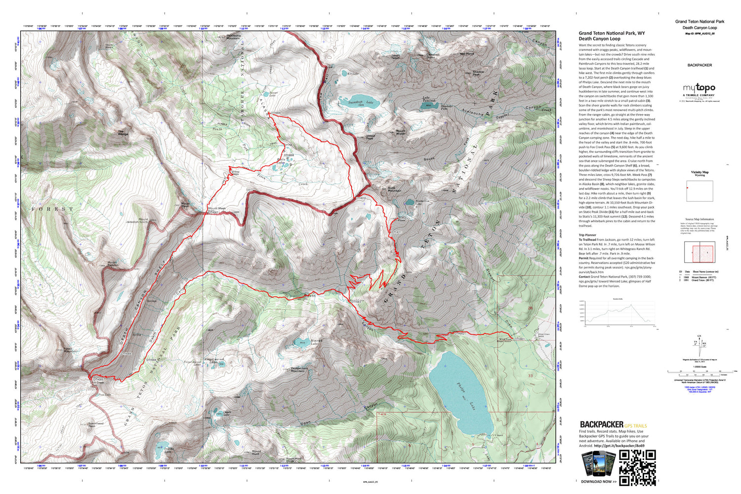
Death Canyon Loop Map (Grand Teton NP, Wyoming)
Couldn't load pickup availability
A special Backpacker Magazine topo map printed on waterproof, tearproof paper. Includes topographic map data from the USGS and detailed trip information
Want the secret to finding classic Tetons scenery crammed with craggy peaks, wildflowers, and mountain lakes—but not the crowds? Drive south nine miles from the easily accessed trails circling Cascade and Paintbrush Canyons to this less-traveled, 28.2-mile lasso loop. Map includes turn-by-turn hiking directions and in-depth trip planning essentials to help you experience this BACKPACKER PRO adventure.
Contains the following named locations: Alaska Basin,Alaska Basin Trail,Albright Peak,Amphitheater Lake Trail,Avalanche Canyon,Bannock Falls,Basin Lakes,Battleship Mountain,Buck Mountain,Cleft Falls,Cloudveil Dome,Coyote Lake,Death Canyon,Death Canyon Shelf,Devils Stairs,Forget-me-not Lakes,Fossil Mountain,Fox Creek Pass,Hurricane Pass,Icefloe Lake,Indian Lake,J Y Ranch,Kit Lake,Lake Taminah,Marion Lake,Mount Bannon,Mount Hunt,Mount Hunt Divide,Mount Jedediah Smith,Mount Meek,Mount Meek Pass,Mount Wister,Nez Perce,Open Canyon,Open Canyon Trail,Pass Lake,Phelps Lake,Prospectors Mountain,R Lazy S Ranch,Rimrock Lake,Schoolroom Glacier,Shadow Peak,Sheep Steps,Shoshoko Falls,Snowdrift Lake,South Fork,South Fork Avalanche Canyon,South Teton,Spalding Falls,Spearhead Peak,Static Peak,Sunset Lake,Surprise Lake,The Wall,The Wedge,Timberline Lake,Valley Trail,Veiled Peak,White Grass Ranch,White Grass Ranger Station


