MyTopo
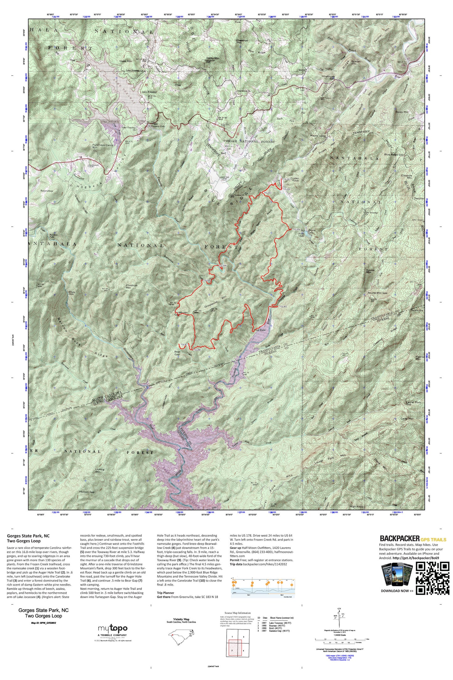
Two Gorges Loop Map (Gorges State Park, North Carolina)
Couldn't load pickup availability
A special Backpacker Magazine topo map printed on waterproof, tearproof paper. Includes topographic map data from the USGS and detailed trip information
Savor a rare slice of temperate Carolina rainforest on this 16.8-mile loop over rivers, though gorges, and up to soaring ridgetops in an area gone green with more than 130 species of plants.
Contains the following named locations: 28747,28772,Ann Creek,Ash Cove,Auger Fork Creek,Bad Creek,Bear Creek,Bear Gap,Bear Wallow Hollow,Bear Wallow Springs,Bearcamp Creek,Bearpen Creek,Bearwallow Creek,Big Ridge,Blue Ridge Branch,Blue Ridge Gap,Blue Ridge Hills Lake,Blue Ridge Hills Lake Dam,Bynum Branch,Cane Brake,Cane Mountain,Chestnut Mountain,Chestnut Ridge,Claypole Mountain,Cobb Creek,Cove Hollow,Crossroads Mountain,Deep Ford Creek,Devils Hole Creek,Diamond Creek,Diana Mountain,Eastatoe Ford,Flat Creek,Flatrock Mountain,Fox Ridge,Frozen Creek,Frozen Knob,Frozen Lake,Frozen Lake Dam,Frozen Mountain,Gorges State Park,Grassy Ridge,Grindstone Mountain,Hawk Mountain,Hickory Gap,High Knob,Hogback,Hogback Valley,Horse Pasture School,Horsepasture River,Horsepasture Wild and Scenic River,Indian Creek,Indian Lake Estates,Indian Lake Upper,Indian Lake Upper Dam,Jackies Branch,Lake Toxaway,Lake Toxaway Church,Lake Toxaway Fire Department,Lake Toxaway Fire Rescue Station 2,Lake Toxaway Post Office,Laurel Branch,Laurel Fork Creek,Laurel Fork Gap,Laurel Fork Mountain,Licklog Mountain,Little Creek,Little Panthertail Mountain,Long Branch,Maple Gap,Maple Spring Branch,McKinney Mountain,Mill Creek,Morton Creek,Musterground Mountain,Nancy Mountain,Narrow Rock Ridge,Noname,North Fork Flat Creek,North Fork French Broad River,Oak Grove Church,Oakland Cemetery,Old Toxaway Baptist Church Lower Cemetery,Old Toxaway Baptist Church Upper Cemetery,Old Toxaway Church,Panther Branch,Panther Gap,Panther Mountain,Pine Ridge,Puncheon Camp Mountain,Quebec,Quebec Mountain,Rainbow Falls,Reid,Ridge Haven,Rock Creek,Rocky Mountain,Rosman Elementary School,Round Mountain,Round Mountain Gap,Roundtop,Sal Creek,Sapphire Post Office,Schoolpath Branch,Side-of-Mountain Creek,South Fork Flat Creek,The Wilds Dam,Township of Hogback,Toxaway Creek,Toxaway Falls,Toxaway Lower Dam,Turkeypen Gap,Upper Lake Toxaway,Upper Lake Toxaway Dam,West Fork French Broad River,Whetstone Gap,Whetstone Ridge,Whitewater Falls,Windy Falls,Woodruff Branch,Woodruff Mountain