MyTopo
Mount Washington: Routes to the Summit Map (White Mountains NF, New Hampshire)
Couldn't load pickup availability
A special Backpacker Magazine topo map printed on waterproof, tearproof paper. Includes topographic map data from the USGS and detailed trip information
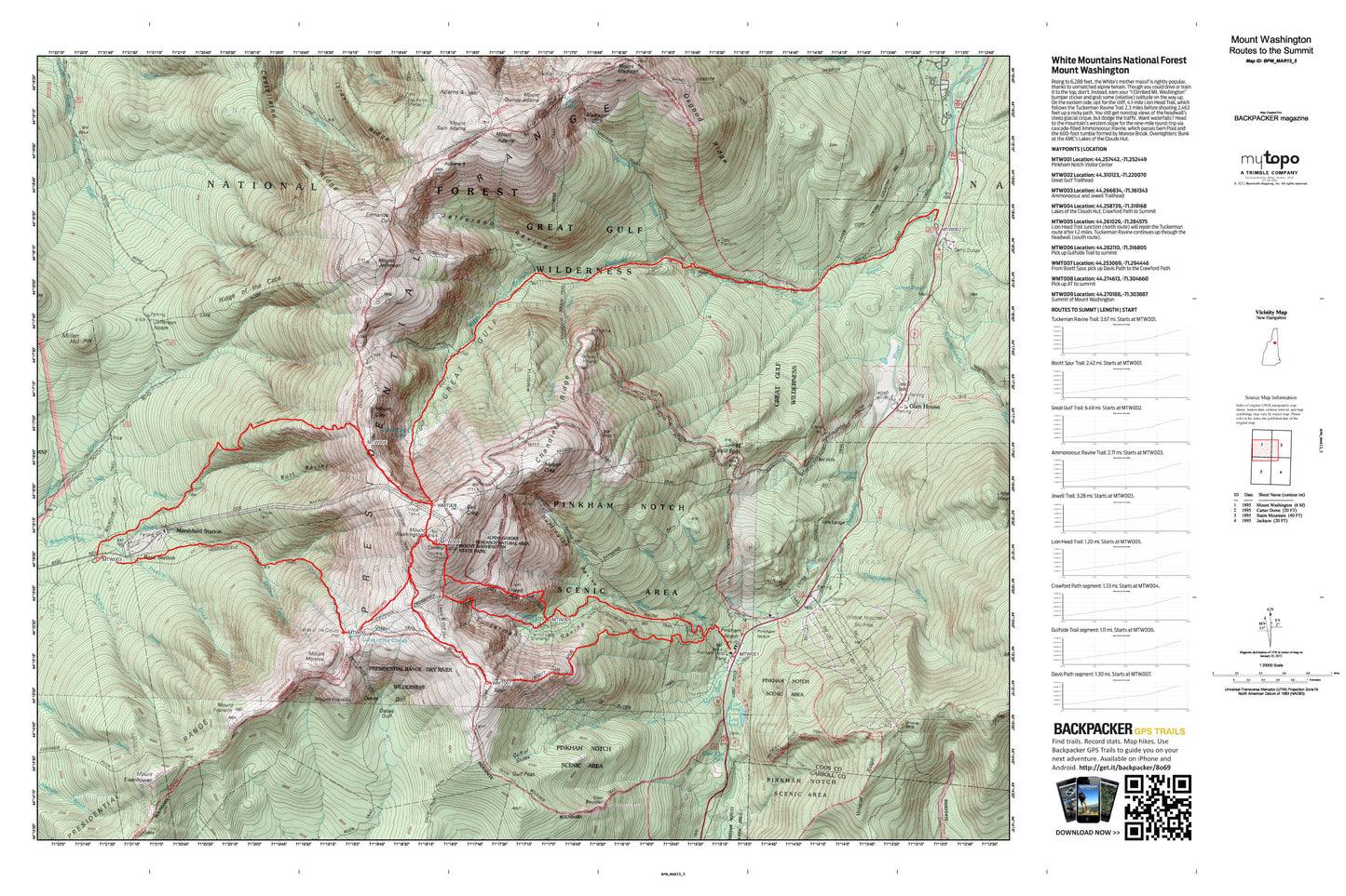
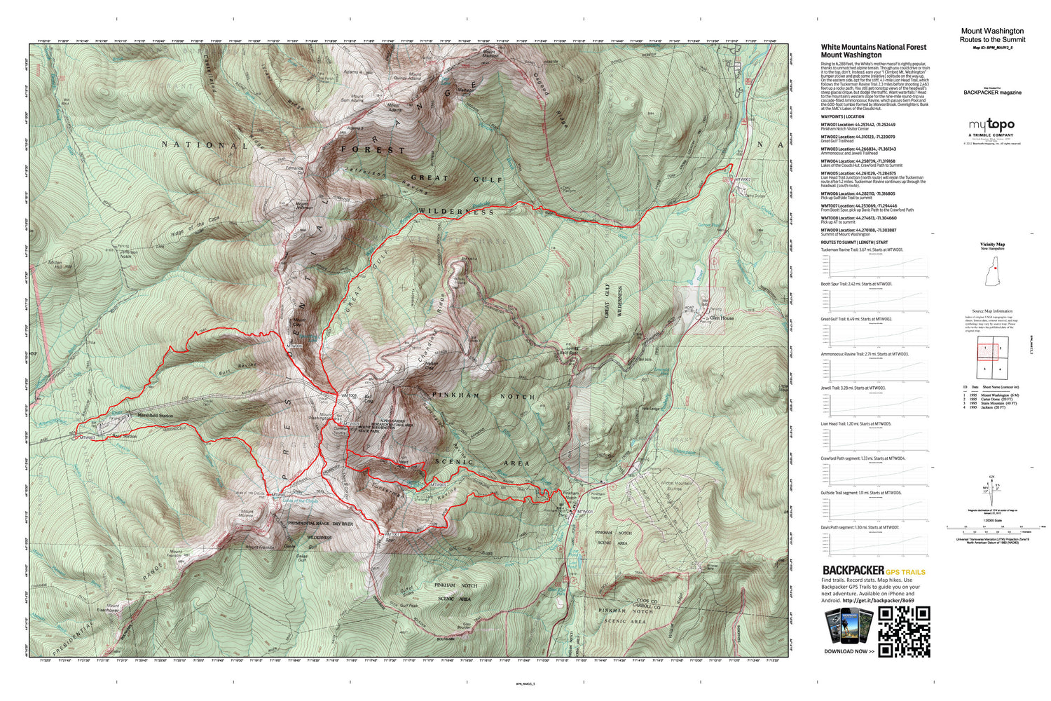
Rising to 6,288 feet, the White’s mother massif is rightly popular, thanks to unmatched alpine terrain. Though you could drive or train it to the top, don’t. Instead, earn your “I Climbed Mt. Washington” bumper sticker and grab some (relative) solitude on the way up. On the eastern side, opt for the stiff, 4.1-mile Lion Head Trail, which follows the Tuckerman Ravine Trail 2.3 miles before shooting 2,463 feet up a rocky path. You still get nonstop views of the headwall’s steep glacial cirque, but dodge the traffic. Want waterfalls? Head to the mountain’s western slope for the nine-mile round-trip via cascade-filled Ammonoosuc Ravine, which passes Gem Pool and the 600-foot tumble formed by Monroe Brook. Overnighters: Bunk at the AMC’s Lakes of the Clouds Hut. Map includes turn-by-turn hiking directions and in-depth trip planning essentials to help you experience this BACKPACKER PRO adventure.
Contains the following named locations: 03593,Adams Five,Adams Slide Trail,Agiocochook Crag,Alpine Garden Trail,Alpine Gardens,Aqueduct Path,Ball Crag,Bigelow Lawn,Boott Spur,Boott Spur Trail,Burt Ravine,Buttress Trail,Castellated Ridge,Castle Path,Chandler Brook,Chandler Ridge,Chandlers Purchase,Clay Brook,Cowboy Brook,Crawford Path,Crew Cut Trail,Cutler River,Daniel Webster Trail,Davis Path,Desolation Pond,Dolly Copp Campground,Durand Ridge,Edmands Col,Edmands Path,Emerald Pool,Franklin Brook,Garnet Pool,Glen Boulder,Glen Boulder Trail,Glen Ellis Falls,Glen Ellis Falls Picnic Area,Glen Ellis Falls Scenic Area,Glen House,Gordon Ridge,Great Gulf,Great Gulf Shelter,Great Gulf Trail,Great Gulf Wilderness,Greens Grant,Gulf of Slides,Gulf Peak,Gulfside Trail,Hermit Lake,Howker Ridge,Huntington Ravine,Imp Brook,Israel Ridge,Israel River Ranger Station,Jefferson Brook,Jefferson Notch,Jefferson Ravine,Jewell Trail,Lakes of the Clouds,Lion Head,Little Wildcat Mountain,Lost Pond,Low and Burbanks Grant,Lows Bald Spot,Madison Gulf,Marshfield Station,Martins Location,Millen Hill,Monroe Brook,Montalban Ridge,Mount Abigail Adams,Mount Adams,Mount Bowman,Mount Clay,Mount Eisenhower,Mount Eisenhower Trail,Mount Franklin,Mount Jefferson,Mount Madison,Mount Mitten,Mount Monroe,Mount Quincy Adams,Mount Sam Adams,Mount Washington,Nelson Crag,Nelson Crag Trail,New River,Nineteen Brook,Nineteenmile Brook Trail,Nowell Ridge,Oakes Gulf,Oakes Gulf Trail,Old Jackson Road,Osgood Ridge,Osgood Trail,Parapet Brook,Peabody Field Picnic Area,Pinkham Notch,Pinkham Notch Camp,Pinkham Notch Scenic Area,Pinkham Notch Visitor Center,Pinkhams Grant,Presidential Range,Raymond Path,Ridge of the Caps,Six Husbands Trail,Spaulding Lake,Sphinx Trail,Star Lake,Summit House,Thompson and Meserves Purchase,Thompson Brook,Tip-Top House,Tuckerman Ravine,Vals Ledge,Wamsutta Trail,Washburn Point,West Branch Peabody River,Westside Trail,White Mountains,WHOM-FM (Mount Washington),Wildcat Mountain,Wildcat Mountain Ski Area,Wildcat Ridge,Wildcat Ridge Trail,WZPK-FM (Berlin)