MyTopo
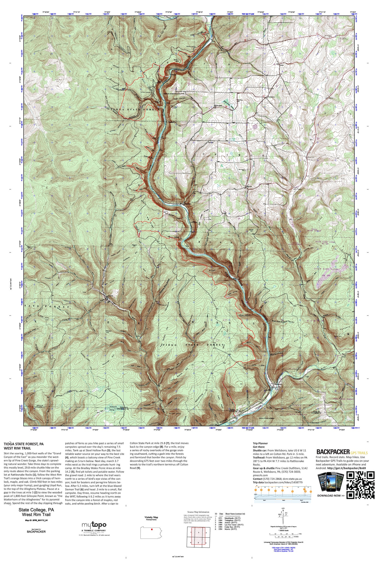
West Rim Trail Map (Tioga State Forest, Pennsylvania)
Couldn't load pickup availability
A special Backpacker Magazine topo map printed on waterproof, tearproof paper. Includes topographic map data from the USGS and detailed trip information
Skirt the soaring, 1,000-foot walls of the “Grand Canyon of the East” as you meander the western lip of Pine Creek Gorge, the state’s sprawling natural wonder. Take three days to complete this mostly level, 29.8-mile shuttle hike on the only route above the canyon. Map includes turn-by-turn hiking directions and in-depth trip planning essentials to help you experience this BACKPACKER PRO adventure.
Contains the following named locations: 16901,16938,Algerine Swamp Bog,Algerine Swamp Natural Area,Ashworth Trail,Ayers Hollow,Babb Creek,Bacon Family Burial Ground Cemetery,Bake Oven Trail,Balsam,Barbour Rock,Bartle Cemetery,Bear Run,Bearpen Hollow,Beaver Hollow,Beecher Hollow,Benjamin Hollow,Big Dam Hollow,Big Dam Hollow Trail,Big Ridge,Big Run,Birch Hollow,Black Run,Blackwell,Bohen Run,Bohen Trail,Brace Hollow,Bradley Wales Picnic Area,Brill Hollow,Brown Point,Browns Lake,Browns Lake Dam,Buck Run,Bull Run,Burdic Run,Bushkirk Trail,Buskirk Hollow,Butler Hollow,Callahan Hill,Callahan Hollow,Campbell Hollow,Campbells Run,Carson Hollow,Carson Hollow Trail,Cedar Mountain,Chaffee Run,Chestnut Trail,Clay Mine Run,Cobble Hill,Colton Point,Colton Point Park,Dam Hollow,Darling Run,Dead Horse Hollow,Deadman Trail,Deer Lick Hollow,Dewey Hollow,Dewey Hollow Trail,Dexter,Dillon Trail,Dixie Run,Dixon Hollow,Doane,Draper,Dry Hollow,East Branch Cedar Run,East Branch Stony Fork,East Branch Trail,East Hill,East Mine Hole Run,Fahnestock Hill,Fahnestock Run,Fall Run,Farmer Shanty Trail,Filmore Hollow,First Switchback Trail,Fork Hill,Fork Hill Trail,Fork Point,Fourmile Run,Frying Pan Run,Gilbert Run,Gleason Hill,Gleason Hollow,Good Spring Hollow,Grand Canyon of Pennsylvania,Gundigut Valley,Half Mile Trail,Hamilton Hollow,Harrison Lookout,Heise Run School,Horse Run,Huck Trail,Hurlbert Hollow,Ice Break Run,Indian Bill Hollow,Jenkins Hollow,Jerry Run,Johnny McHood Trail,Johnson Run,Kennedy,Kennedy Cemetery,Lee Fire Tower,Leetonia,Left Branch Fourmile Run,Left Steele Run Trail,Leonard Harrison State Park,Lewis Cemetery,Lick Run Hill,Little Fourmile Run,Little Morris Trail,Little Slate Run,Lloyd Point,Lloyd Post Office,Lloyd Run,Lloyd Trail,Locks Hollow,Long Branch,Long Branch Hill,Madison Hollow,Matson Spring,Mattison - Lick Run Cemetery,Middle Ridge Church,Middle Ridge Swamp,Mill Hollow,Mill Run,Mine Hole Run,Misner Hollow,Mitchell Hollow,Morris Trail,Morrison Hollow,Number 2 Hollow,O'Connor Branch,O'Connor Trail,Old Mountain Trail,Olive Draft,Olmsville,Orchard Spring,Owassee,Owassee Slide Run,Paint Run,Pinafore Run,Pine,Pine Creek Gorge Natural Area,Pine Island Run,Pine Trail,Plantatation Trail,Rail Island Run,Red Ledge Ridge,Red Rock Run,Red Rock Trail,Refuge Trail,Rexford Branch,Rexford Trail,Reynolds Spring Bog,Reynolds Spring Trail,Rice Hollow,Right Branch Fourmile Run,Right Steele Run Trail,Roby Hollow,Roland Run,Russell Hill,Schoolhouse Run,Schoonover Hollow,Semans Trail,Shaver Hollow,Sherman School,Slide Island Draft,Spinning Wheel Branch,Spinningwheel Trail,Sprinkling Can Hollow,State Game Lands Number 268,Steel Hollow,Steel Hollow Trail,Stone Quarry Run,Stone Quarry Trail,Stony Fork,Stony Fork Baptist Church Cemetery,Stony Fork Butler Family Cemetery,Stony Fork Mennonite Church Cemetery,Stony Fork Picnic Area,Stowell Run,Straight Creek,Straight Run,Strap Mill Hollow,Tamarack Swamp,Tannery Hill,Thompson Hollow,Thumptown,Tiadaghton,Township of Delmar,Township of Elk,Township of Morris,Trestle Hollow,Trestle Hollow Trail,Tumbling Run,Tumbling Run Trail,Vanaimes Hill,Water Tank Run,Water Tank Trail,Water Trough Hollow,Water Trough Trail,Wellsboro Country Club,Wellsboro Johnston Airport,West Branch Cedar Run,West Branch Cemetery,West Branch Stony Fork,West Branch Trail,West Hill,West Mine Hole Run,White Horse Hollow,Wild Apple Trail,Windfall Hollow,Winnie Hollow,Woodhouse Run


