MyTopo
Mid-Smokies Circuit (Great Smoky Mountains National Park, Tennessee)
Couldn't load pickup availability
A special Backpacker Magazine topo map printed on waterproof, tearproof paper. Includes topographic map data from the USGS and detailed trip information
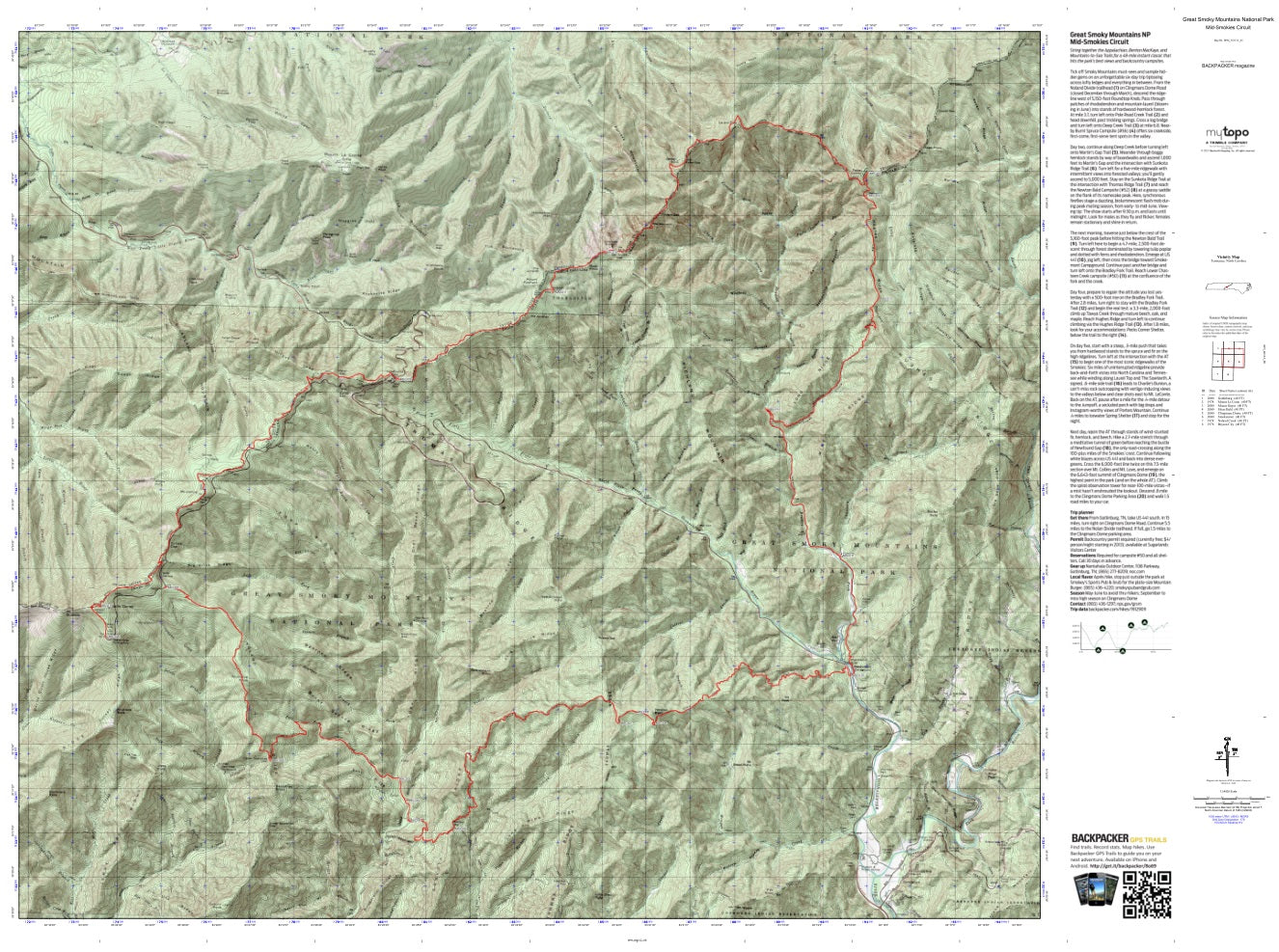
String together the Appalachian, Benton MacKaye, and Mountains-to-Sea Trails for a 48-mile instant classic that hits the park’s best views and backcountry campsites. Map includes turn-by-turn hiking directions and in-depth trip planning essentials to help you experience this BACKPACKER PRO adventure.
Contains the following named locations: 28719,37738,Ace Creek,Aden Branch,Alum Cave Creek,Anakeesta Knob,Anakeesta Ridge,Andrews Bald,Arch Rock,Bald Branch,Bald Creek Campground,Ballhoot Scar Overlook,Balsam Point,Balsam Ridge,Batsaw Branch,Bearpen Branch,Bearpen Ridge,Bearwallow Branch,Becks Bald,Becks Branch,Beech Flats Prong,Beetree Creek,Beetree Ridge,Big Branch,Big Slick Ridge,Bills Creek,Boulevard Prong,Bradley Fork,Breedlove Branch,Bridge Creek,Brushy Mountain,Bryson Place,Buckhorn Bald,Bull Head,Bulldie Creek,Bulldie Ridge,Bumgardner Ridge,Burnt Spruce Ridge,Cabin Branch,Cannon Creek,Charlies Bunion,Chasm Prong,Chasteen Creek,Cherokee Orchard,Cherry Cove Branch,Cherry Creek,Chimney Tops,Chimneys Campground,Cliff Branch,Cliff Top,Clingmans Creek,Clingmans Dome,Coburn Knob,Cole Creek,Collins Creek,Commissioner District 11,Coon Branch,Couches Creek,Critter Branch,Devil Branch,Devils Court House Ridge,Easy Ridge,Elliott Cove Branch,Enloe Creek,Enloe Ridge,Estes Branch,Fork Ridge,Forney Ridge Parking Area,Fort Harry,Fountain Branch,Fox Knob,Frowning Rock Prong,Galamore Branch,Georges Branch,Grass Patch Branch,Grassy Branch,Great Smoky Mountains,Great Smoky Mountains National Park,Grotto Falls,Grouse Creek,Gulf Prong,Hermit Branch,Hickory King Branch,Hideaway Brook,High Top,Highland Ridge,Horseshoe Branch,Horseshoe Mountain,Huggins Hell,Hughes Ridge,Hunter Creek,Huskey Creek,Icewater Spring Shelter,Jack Bradley Branch,Jerry Bald,Jerry Bald Ridge,Jim Carr Mill,Jim Mac Branch,Jim Ute Branch,Jim Ute Ridge,Kanati Fork,Katalsta Ridge,Keeyuga Creek,Keg Drive Branch,Kephart Prong,Kephart Shelter,Kuwahi Branch,Laurel Top,Le Conte Lodge,Left Fork Deep Creek,Left Fork Raven Fork,Lester Prong,Little Creek Falls,Little Niagara Creek,Loggy Ridge,Louie Camp Branch,Lower Grassy Branch,Lower Ripshin Branch,Lowes Creek,Madcap Branch,Masa Knob,McCracken Branch,Meigs Post Prong,Middle Fork Raven Fork,Mine Branch,Mingo Creek,Mingo Falls,Mingus Creek,Mingus Lead,Minnie Ball Branch,Moccasin Branch,Morton Overlook,Mount Ambler,Mount Buckley,Mount Clark,Mount Collins,Mount Collins Shelter,Mount Kephart,Mount Le Conte,Mount LeConte Shelter,Mount Love,Mount Mingus,Mount Noble,Mount Sequoyah,Mount Stand Watie,Mount Weaver,Myrtle Point,Nettle Creek,Nettle Creek Bald,Newton Bald,Newton Branch,Nicks Nest Branch,Oconaluftee River Overlook,Pecks branch,Pecks Corner,Pecks Corner Branch,Pecks Corner Shelter,Peregrine Peak,Peruvian Branch,Pigeon Creek,Piney Mountain,Poke Patch Campsite,Pole Road Creek,Poplar Hollow Branch,Porters Flat Campsite,Porters Mountain,Rainbow Falls,Ramp Cove Branch,Ramp Creek,Rattler Branch,Rattlesnake Knob,Raven Creek,Raven Fork,Raven Fork Overlook,Ravensford,Richland Mountain,Right Fork Raven Fork,Road Prong,Road Turn Branch,Rocky Fork,Rocky Spur,Roundtop Knob,Sahlee Creek,Salola Branch,Sassafras Branch,Sassafras Knob,Scratch Britches,Shell Bark Branch,Sherrill Cove Branch,Shirt Tail Branch,Shutts Prong,Smith Branch,Smokemont,Smokemont Campground,Smokemont Group Camp,Soggy Hill Branch,Springhouse Branch,Spud Town Branch,Steeltrap Creek,Steep Branch,Styx Branch,Sugar Branch,Sugarland Mountain,Sugarlands Utility Area,Sweat Heifer Creek,Sweet Creek,Sweet Ridge,Tabor Branch,Taywa Creek,Tennessee Branch,The Boulevard,The Loop,The Sawteeth,Thirst Branch,Three Forks,Three Forks Campsite,Tomahawk Prong,Tow String Creek,Tow String Horse Camp,Township of Charleston,Trillium Branch,Trout Branch,Turkey Flyup,Twomile Lead,Upper Grassy Branch,Upper Ripshin Branch,Walker Camp Prong,Washout Branch,Webb Overlook,West Point,Whitewater Branch,Wild Cherry Branch,Will Branch,Wilson Falls,Woolly Tops Mountain