MyTopo
Colorado GMU 214 Map
Couldn't load pickup availability
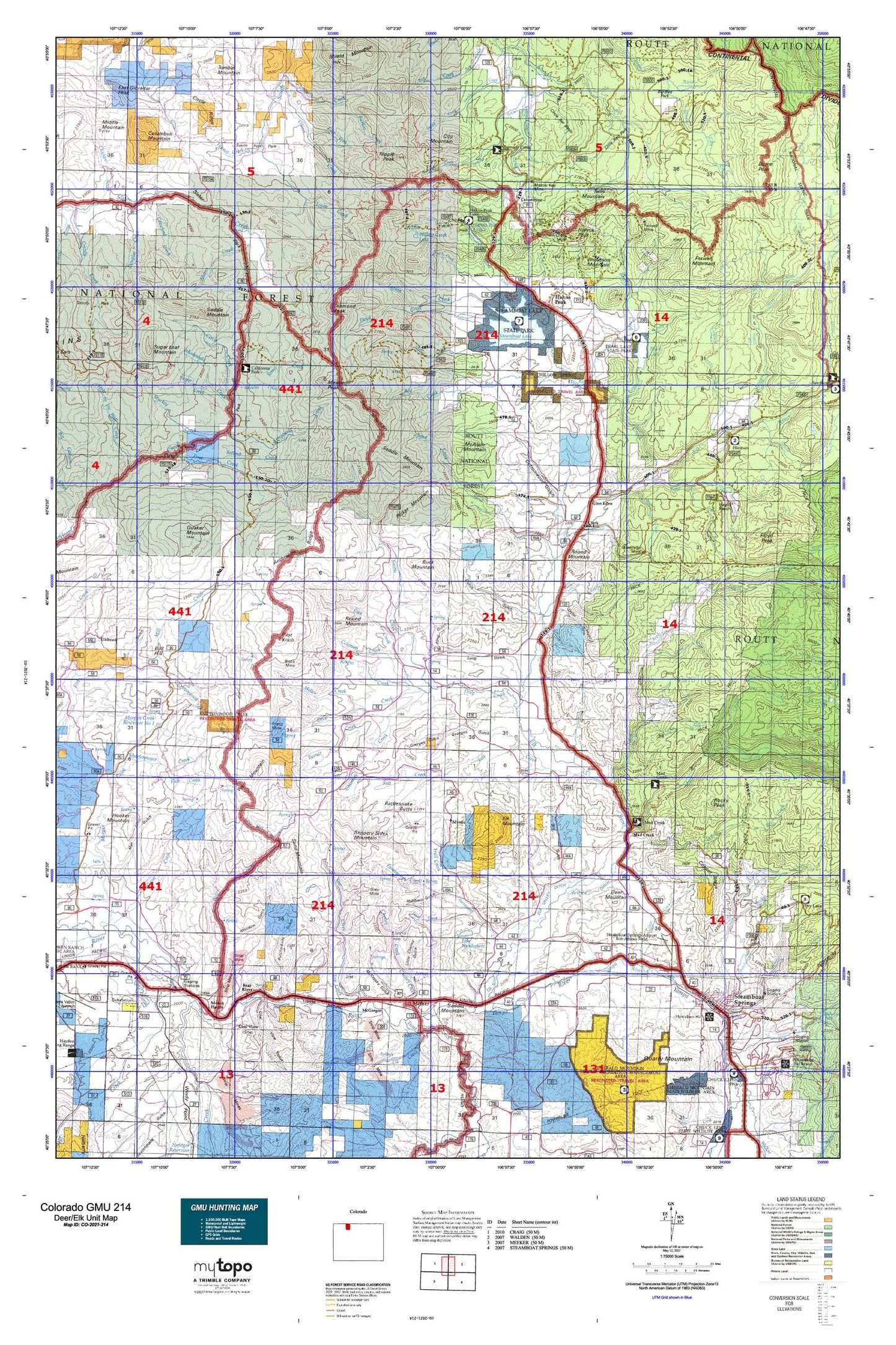
Hunting unit map of Colorado Game Management Unit 214 with topographic lines and unit boundaries. This topo map features UTM / MGRS and Latitude/Longitude grids, plus public land ownership. It comes folded on waterproof paper. Be fully prepared for your hunt with a MyTopo GMU map!.
This map contains the following named places: 80428,80477,80487,Acme Placer,Adams Creek,Amos Mine,Anderson Mountain,Armstrong Creek,Ashponds Hayden Station,Batton Ditch,Bear Creek,Bear River,Beaver Creek,Beryl Mountain,Big Creek,Big Creek Bridge Trail,Black Cat Coal Mine,Blazer Mine,Block Mine,Blue Jay Mine,Bootjack Ranch,Boyer Reservoir,Buck Mountain,Bull Hill,Burton Creek,Burton Creek Trail,Butcherknife Creek,Butcherknife Mine,Cabin Creek,California Park Guard Station,Campbell Ditch,Cap Smith Hill,Champion Mine,Cheney Creek,Chilton Trail,Chimney Creek,Christina State Wildlife Area,Circle Creek,City Mountain,City of Steamboat Springs,Clark,Coal View,Coleman Creek,Columbine,Columbus Mountain,Corral Creek,Coulton Creek,Coulton Creek Campground,Coulton Creek Trail,Cow Creek,Crawford Creek,Day Creek,Deep Creek,Deer Mountain,Diamond Peak,Dick Jones Mine,Ditch Creek,Dixie Mine,Dome Peak,Douglas Creek,Dutch Creek,Dutch Hill Campground,East Fork Oliver Creek,Elk Creek,Elk Mountain,Elk Park Trail,Elk River,Elk Valley Ditch,Emancipation Group,Farnsworth Creek,Farwell Creek,Farwell Lake,Farwell Mine,Farwell Mountain,Fawn Creek,First Creek,Fish Creek,Fish Creek Reservoir,Floyd Creek,Floyd Peak,Frantz Ditch,Franz Creek,Franz Mine,Gibralter Ditch,Glen Eden,Gold Pan Campground,Goose Creek,Grassy Creek,Greenville Creek,Greenville Mine,Grey Mine,Grouse Mountain,Gunn Creek,Hahns Peak,Hahns Peak Lake,Hahns Peak Lake Campground,Hahns Peak Lookout,Hahns Peak NW Mine,Hayden Division,Hayden Station,Hinman Campground,Hinman Creek,Hinman Creek Trail,Hinman Lake,Hole-in-the-Wall Creek,Hooker Mountain,Hot Spring Creek,Hot Springs Highline Ditch,Howelsen Hill,Howelsen Hill Ski Area,International Mine,Iron Mountain,Iron Mountain Mine,Iron Springs Mine,Johnson Creek,Jokodowski Creek,Jolley Ranch,Keller Ditch,King Solomon Creek Mine,Knowles Creek,Lake Windemere,Larson Creek,Lester Creek,Lester Mountain,Little Mountain,Little Wolf Creek,Lopez Creek,Mad Creek,Mad Creek Trailhead,Marshall Roberts Ditch,Master Key Mine,McAlpin Mountain,McCargar Reservoir,McGregor,McPhee Creek,Meaden Peak,Meadows Number One Mine,Middle Fork Campground,Middle Fork Mad Creek,Mill Creek,Miller Creek,Milner,Milner Landfill,Milner Spring Creek,Minnie D Mine,Moon Hill,Morgan Creek,Mount Candy,Mount Harris,Mount Harris Mine,Mount Pau,Murphy Ditch,Mystic,Nipple Peak,Nipple Peak Trail,North Fork Mad Creek,Oliver Creek,Oliver Creek Trail,Pearl Lake,Pearl Lake State Park,Picket Mountain,Pilot Knob,Placer Cove Picnic Area,Pond Lily Lakes,Poverty Bar Campground,Prospector Trail,Quaker Mountain,Rattlesnake Butte,Red Creek,Red Dirt Trail,Reed Creek,Renfro Creek,Roaring Fork Creek,Roaring Fork Trail,Rock Creek,Rocky Peak,Round Mountain,Routt County,Royal Flush Mine,Rustic Coal Mine,Saddle Mountain,Sage Creek,Salt Creek,Sand Creek,Sand Creek Ditch,Sand Mountain,Scott Run,Second Creek,Seedhouse Campground,Shaefermeyer Creek,Site Two Forest Service Facility,Slate Creek,Slippery Sides Mountain,Smith Creek,Smith Ranch,Soda Creek,South Fork Elk River,South Fork Mad Creek,South Franz Creek,Southern Cross Mine,Spring Creek,Steamboat II,Steamboat Lake,Steamboat Lake State Park,Steamboat Springs,Steamboat Springs Division,Stukey Creek,Success Mine,Sugar Creek,Sugar Loaf Mountain,Summit Creek,Summit Creek Guard Station,Sunrise Vista Campground,Swamp Park Trail,The Sleeping Giant,Tom Thumb Mine,Torso Creek,Tow Creek,Trout Creek,Trout Creek Number One Mine,Trull Creek,Tumble Mountain,Tunnel Creek,Turner Creek,Twin Mountain,Twin Mountain Mine,Walrod Reservoir,Wapiti Ranch,West Fork Elk River,Willow Creek,Willow Creek Lake,Wither Ditch,Wolf Creek,Wolf Mountain,Woodchuck Ditch