
MyTopo
Colorado GMU 25 Map
Couldn't load pickup availability
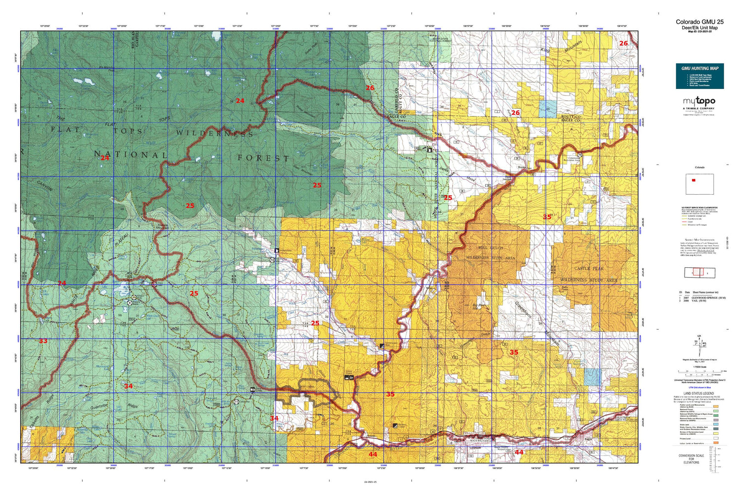
Hunting unit map of Colorado Game Management Unit 25 with topographic lines and unit boundaries. This topo map features UTM / MGRS and Latitude/Longitude grids, plus public land ownership. It comes folded on waterproof paper. Be fully prepared for your hunt with a MyTopo GMU map!.
This map contains the following named places: 80426,81637,Adams Lake,Agnew Gulch,Alamo Creek,Ballixburg Spring,Baxter Peak,Big Red Hill,Big Spring,Bison Lake,Bison Lake Campground,Bison Lake Dam,Black Mountain,Blair Lake,Blair Mountain,Blowout Hill,Blowout Hill Mine,Blue Lake,Bowen Lake,Broken Rib Creek,Broken Rib Spring,Buck Creek,Buck Lake,Bugle Lake,Bull Gulch,Bull Lake,Burns,Burns Post Office,Cabin Creek,Camp Creek,Canard Creek,Carbonate,Cease Creek,Cedar Creek,Clock Lake,Coffee Pot Spring Campground,Coyote Park,Crane Park,Crater Lake,Crescent Lake,Crescent Lake Number 1 Dam,Crescent Lake Number 2,Crescent Lake Number 2 Dam,Cross Creek,Dade Mine,Darnell Creek,Deadhorse Spring,Deep Creek,Deep Creek Mine,Deep Creek Overlook,Deep Lake,Deep Lake Campground,Deep Lake Campground Number 2,Deer Creek,Deer Park,Derby Creek,Derby Guard Station,Derby Junction,Derby Mesa,Doe Creek,Dotsero Crater,Dotsero Wildlife Area,Dry Buck Creek,Dry Fork Cabin Creek,Dry Lake,Dry Sweetwater Creek,Duck Lake,East Fork Red Dirt Creek,East Fork Sheep Creek,Elbow Park,Elk Knob,Elk Lakes,Emerald Lake,Fargo Gulch,Fawn Creek,Flatiron Mountain,G G Upper Dam,Gallagher Lake,Glenwood Springs Division,Greenhorn Creek,Greenhorn Gulch,Greenhorn Mountain,Grizzly Cow Camp,Grizzly Lake,Gruner Creek,Hack Creek,Hack Lake,Hangmans Rock,Heart Lake,Heart Lake Dam,Heart Lake Reservoir,Hells Gate,Hidden Spring Dam,Hidden Spring Reservoir,High Trail,Hilltop Ranch,Horse Creek,Horse Lake,Horseshoe Lake,Hunns Peak,Indian Camp Pass,Indian Lake,Irrawaddy Creek,Irrawaddy Spring,Island Lake,Jack Creek,Jack Flats,Jack Spring,Jet Lake,Johnny Meyers Lake,Johnson Creek,Klines Folly Campground,Lake Creek,Leroy Spring,Lion Basin Ditch,Little Sugarloaf Mountain,Lost Solar Park,Lower Short Creek,Luark Dam,Luark Reservoir,Lucky Gulch,Lyons Gulch,Mackinaw Lake,Marvine Lakes,Mason Creek,Maynes Spring,McMillan Lake,Middle Fork Derby Creek,Monegar Ridge,Monument Lake,Morris Creek,Mud Spring,Natural Bridge,Nichols Creek,North Fork Derby Creek,Onion Ridge,Oyster Lake,Palmer Lake,Park Creek,Patterson Creek,Poison Creek,Porphyry Mountain,Posey Creek,Price Dam,Price Reservoir,Pump Gulch,Quartzite Ridge,Range,Red Dirt Bridge,Red Dirt Creek,Riland Community Center,Riland Creek,Rim Lake,Sams Spring,Shadow Lake,Sheep Gulch,Sheep Mountain,Sheep Spring,Shepherd Lake,Shingle Lake,Shingle Peak,Short Creek Spring Number 1,Short Creek Spring Number 2,South Derby Ditch,South Derby Trail,South Fork Derby Creek,South Fork Falls,South Grizzly Creek,Spring Hill,Star Lake,Still Waters,Sugarloaf Mountain,Sunnyside Creek,Supply Basin Campground,Supply Basin Dam,Supply Basin Reservoir,Sweetwater Cow Camp,Sweetwater Creek,Sweetwater Guard Station,Sweetwater Lake,Sweetwater Lake Campground,Tenmile Park,The Flat Tops,The Meadows,Tibbetts Ridge,Timber Mountain,Town of Carbonate,Trail Creek,Trail Gulch,Trappers Peak,Triangle Mountain,Tucker Draw,Turret Creek,Turret Creek Meadows,Turret Peak,Upper Island Lake,Upper Short Creek,Ute Lake,W Mountain,Wagonwheel Creek,West Fork Cottonwood Creek,West Fork Red Dirt Creek,West Fork Sheep Creek,West Saint Louis Creek,White Owl Creek,White Owl Lake,White River Plateau,Willow Creek,Willow Lake,Willow Peak,Willow Spring


