MyTopo
Colorado GMU 31 Map
Couldn't load pickup availability
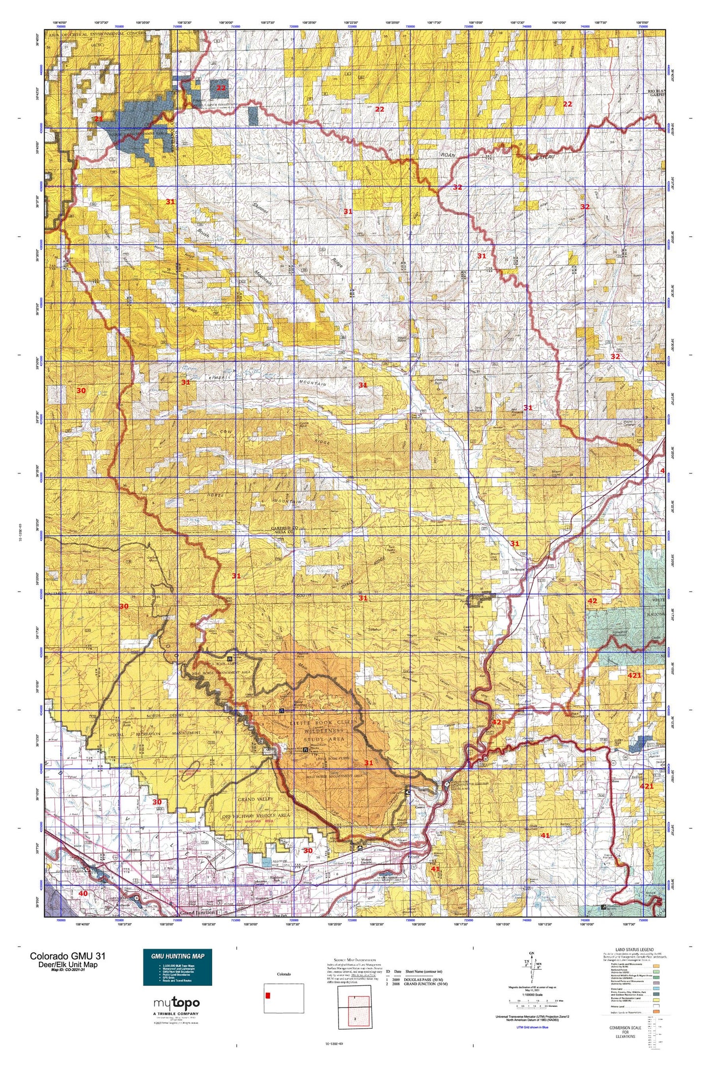
Hunting unit map of Colorado Game Management Unit 31 with topographic lines and unit boundaries. This topo map features UTM / MGRS and Latitude/Longitude grids, plus public land ownership. It comes folded on waterproof paper. Be fully prepared for your hunt with a MyTopo GMU map!.
This map contains the following named places: 4A Point,4A Ridge,81505,81630,Akin,Alkali Creek,Altenbern Ranch,Asbury Creek,Atencio Cabin,Atwell Homestead,Bailey Point,Barnes Ridge,Basin Butte,Baugh Reservoir,Bear Gulch,Bear Point,Bear Run,Beavertail Mountain,Big Wash,Black Diamond Mine,Black Mountain,Blue Flame Mine,Bluestone Valley Ditch,Book Cliff Mine,Bowdish Trail,Boyd Gulch,Boyer Mine,Boyer Peacock Mine,Browns Point,Brush Creek,Brush Mountain,Buck Canyon,Buck Gulch,Bull Fork,Bunk Ridge Retention Dam,Bunkwater Ridge,Cameo,Cameo Number One Mine,Cameo Siding,Camp Gulch,Campbell Number Two Mine,Cannon Ditch,Carr Creek,Carver Homestead,Cascade Canyon,Castle Rock,Caughman Ditch,Cedar Bench,Cherry Gulch,Chimney Rock,Chimney Rock Point,Circle Dot Gulch,Clear Creek,Clear Creek Ditch,Conn Creek,Connley Gulch,Conwell Ditch,Coon Creek,Corcoran Mine,Corcoran Peak,Corcoran Point,Corcoran Wash,Corral Canyon,Corral Gulch,Cottonwood Creek,Cottonwood Ditch,Cow Ridge,Crawford Trail,Creek and Newman Ditch,Crystal Creek,Cuddy Ranch,Cutoff Gulch,Davis Point,De Beque,De Beque Division,De Beque Reservoir,De La Matyr and Anderson Ditch,Deer Park Gulch,Deer Retention Dam,Desert Gulch,Doe Creek,Doe Gulch,Dry Fork Roan Creek,Dry Fork Stewart Gulch,East Fork Conn Creek,East Fork Middle Fork Stewart Gulch,East Monument,East Willow Creek,Eby Point,Echo Lake,Eddington Homestead,Farmer Mutual Mine,Farmers Number Two Mine,Fleming Point,Frank Ball Homestead,Garden Gulch,Garfield Mesa,Gasaway Bench,George Cocharan Mine,Gibler Ditch,Government Highline Canal,Grand Valley Diversion Dam,Granlee Ditch,Grassie and Cozzette Mine,Grasso Mine,Halfway House,Harris Homestead,Haystack Mountain,Henderson Ridge,Hidden Treasure Mine,Hi-Grade Mine,Hobo Ditch,Holland Mine,Horse Mountain,Horse Ridge,Horsethief Creek,Horsethief Mountain,House Log Gulch,Hunter Mine,HVS and S Ditch,Hy Grade Mine,Indian Peak,Jackrabbit Ridge,Jangle Ditch,Jarvis Coal Mine,Jerry Creek,John Held Corner,Kimball Creek,Kimball Mountain,Kimbell Mesa,Larkin Ditch,Left Fork Carr Creek,Left Fork Lake Creek,Left Fork Soldier Creek,Light Gulch,Litchliter Gulch,Little Alkali Creek,Little Creek,Little Horsethief Creek,Little Wash,Logan Wash,Long Point,Low Cost Ditch,Main Line Grand Valley Canal,McGinley Mine,McKay Canyon,McKay Fork,McKay Gulch,Mesa,Mesa Creek,Middle Dry Fork,Middle Fork Soldier Creek,Middle Ranch Canyon,Midway Farmer Number Three Mine,Monarch Mine,Monument Rocks,Mount Blaine,Mount Callahan,Mount Law,Mount Logan,Mud Spring Canyon,Mud Springs Creek,Nichols Pit,No Name Creek,North Dry Fork,North Gulch,Old Black Diamond Mine,Orchard Mesa Siphon,Peacock Mine,Pearl Creek,Pine Ridge,Pine Trail Reservoir,Piute Reservoir,Place Mesa,Plateau Creek,Pole Bridge Canyon,Porcupine Gulch,Potts Creek,Puddin Ridge,Pyramid Rock,Quakie Canyon,Ray Ball Homestead,Razorback Ridge,Red Gulch,Red Pinnacle,Red Point,Redrock Point,Reservoir Ditch,Right Fork Lake Creek,Right Fork Soldier Creek,Roadside Mine,Roan Creek,Roan Creek Community Center,Roan Creek Ditch Number 2,Ross Ridge,Round Mountain,Sawmill Gulch,Scott Gulch,Sheep Gulch,Sheep Kill Gulch,Short Gulch,Skinner Ridge,Sleepy Ridge,Snipes Corral,Soap Retention Dam,South Dry Fork,South Shale Ridge,Spring Creek,Spruce Point Trail,Square S Ranch,Sunnyside Reservoir,Tate Creek,The Lake,Thomas Mine,Tom Creek,Tourist Run,Town of De Beque,Trail Gulch,Trail Ridge,Tunnel,Twin Peaks,Upper 4A Mountain,Ute Trail,Wagon Truck Ridge,West Fork Falls,West Fork Middle Fork Stewart Gulch,West Garfield Division,West Monument,West Willow Creek,Wet Fork West Fork Parachute Creek,Whiskey Gulch,Wiesse Creek,William Mine,Willow Creek,Wolf Creek