MyTopo
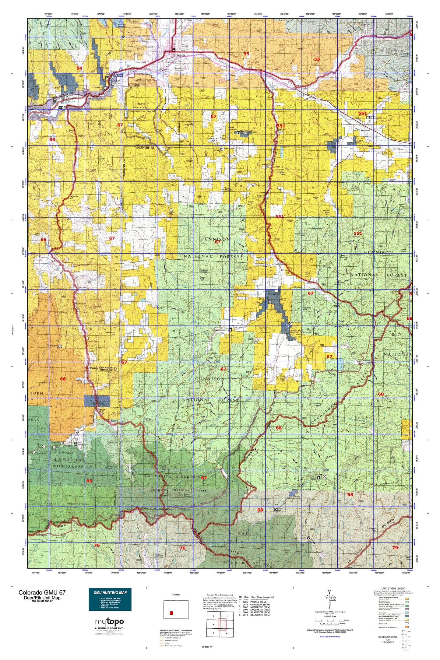
Colorado GMU 67 Map
Couldn't load pickup availability
Hunting unit map of Colorado Game Management Unit 67 with topographic lines and unit boundaries. This topo map features UTM / MGRS and Latitude/Longitude grids, plus public land ownership. It comes folded on waterproof paper. Be fully prepared for your hunt with a MyTopo GMU map!.
This map contains the following named places: 81230,81231,81239,Aberdeen,Agency Peak,Alder Creek,Alkali Creek,American Legion Memorial Park,Ant Creek,Antelope Creek,Arch Irrigation Ditch,Archuleta Creek,Baldy Alto,Baldy Chato,Barret Creek,Bead Creek,Bear Creek,Beaver Creek,Big Basin,Big Mesa,Big Mud Pond,Big Seep Reservoir,Blue Creek,Bondholder Trail,Bowers Lakes,Buck Park Creek,Bull Creek,Burnt Creek,Cabin Creek,Camp Creek,Cascade Creek,Cathedral,Cathedral Creek,Cebolla Campground,Cebolla Game Management Area,Cebolla Stock Driveway,Cebolla Trail,Chance,Chavez Creek,City of Gunnison,Cochetopa Creek,Cochetopa Division,Cochetopa Dome,Cochetopa Meadows Ditch,Cooper Mountain,Cooper Ranch,Coopers Resort,Corbitt Ditch,Corduroy Creek,Corral Creek,Corson Place,Court House Square,Coyote Hill,Crystal Creek,Cunningham Ditch,Deadman Creek,Deep Creek,Deer Beaver Creek,Deer Hill,Deldorado Creek,Devils Hole Trail,Dome Lakes State Wildlife Area,Doyleville,Dry Lake,Duckfoot Creek,East Beaver Creek,East Fork Buck Park Creek,East Fork Los Pinos Creek,East Fork Powderhorn Creek,East Mineral Creek,Elk Creek,Flat Top,Flick Homestead,Flying M Ranch,Fox Creek,Gismo Creek,Gold Basin Creek,Gould Ranch,Green Mesa Ranch,Green Mountain,Gunnison,Gunnison County Fairgrounds,Harris Hereford Ranch,Hidden Lake,Hierro,Hot Springs Creek,Howard Ranch,Huntsman Mesa,Indian Head,Iola,Iris,Iron Hill,Jardine Ranch,Johns Creek,Jones Homestead,Killdeer Creek,Kline Homestead,Kreuger Ranch,La Garita Wilderness,Lake Fork,Lake Fork Cochetopa Creek,Lake Fork Saguache Creek,Left Hand Barret Creek,Legion Park Golf Course,Lemay Wash,Lick Creek,Lions Head,Little Basin,Little Camp Creek,Little Mud Pond,Little North Fork,Little Willow Creek,Los Creek,Los Pinos Creek,Lower Dome Reservoir,Luders Creek Campground,Lujan Creek,Martinez Creek,McCabe Ranch,McDonough Ranch,McDonough Reservoir,Meadows Shopping Center,Mergelmann Cow Camp,Mesa Ditch,Mick Homestead,Middle Barret Creek,Middle Fork Powderhorn Creek,Middle Fork Saguache Creek,Middle Mineral Creek,Midway,Mill Creek,Miller Creek,Miller Hill,Mineral Creek,Mineral Creek Trailhead,Mineral Mountain,Miners Creek,Mitchell Ranch,Monchego Creek,Monument Creek,Monument Rock Creek,Moss Lake,Mountaineer Stadium,Muddy Creek,Neversink Resort,North Beaver Creek,North Fork Saguache Creek,Nutras Creek,Old Agency Ranger Station,Organ Mountain,Park Creek,Parlin,Pasture Creek,Pauline Creek,Perfecto Creek,Perry Ditch,Phelps Cabin Creek,Pine Creek,Pinto Basin,Pole Creek,Polepatch Hill,Post Homestead,Powderhorn,Prosser Creek,Prosser Rock,Quarter Circle Ranch,Quartz Creek,Quemado Creek,Ralston Creek,Razor Creek,Razor Creek Dome,Right Creek,Right Hand Barret Creek,Road Beaver Creek,Road Miller Creek,Rock Creek,Rock Creek Cow Camp,Rough Creek,Rough Creek Trail,Rough Creek Trailhead,Rudolph Hill,Salaya Creek,Sammons Ranch,Samora Creek,San Luis Peak,Sawtooth Mountain,Schisto Basin,School Section Creek,Shaw Ranch,Sheep Creek,Shelton Ranch,Sillsville,Skyline Trail,Slane Creek,Smith Ford Ditch,Smith Place,Soderquist Reservoir,South Beaver Creek,South Fork Saguache Creek,Spring Creek,Spring Hill Creek,Steinbergen Ranch,Steuben Creek,Steuben Ranch,Stevens Creek,Stewart Creek,Stewart Creek Trail,Stewart Peak,Still Creek,Stone Cellar Campground,Stone Cellar Guard Station,Sugar Creek,Sun Creek,Sunshine Creek,Table Mountain,Table Top,Table Top Ranch,Tarbell and Alexander Ditch,Tenderfoot Mountain,Texas Creek,The Wayne N Aspinall Unit,Tomichi Creek,Trail Creek,Upper Dome Reservoir,Vouga Reservoir,Vulcan,Watts Homestead,West Fork Buck Park Creek,West Gismo Creek,West Mineral Creek,West Pass Creek,Willow Creek,Willow Mesa,Winn Trail,Youmans Ranch