MyTopo
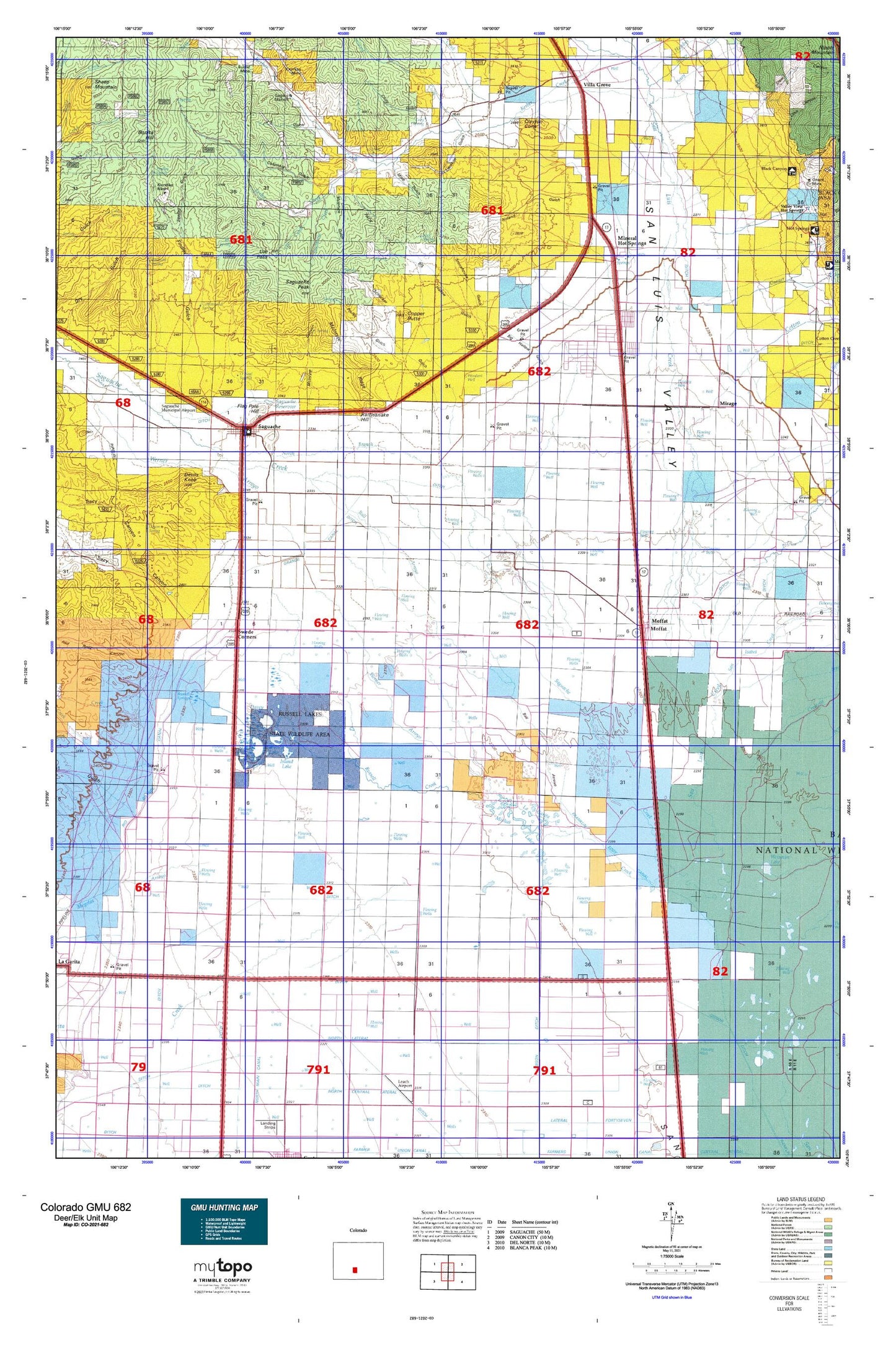
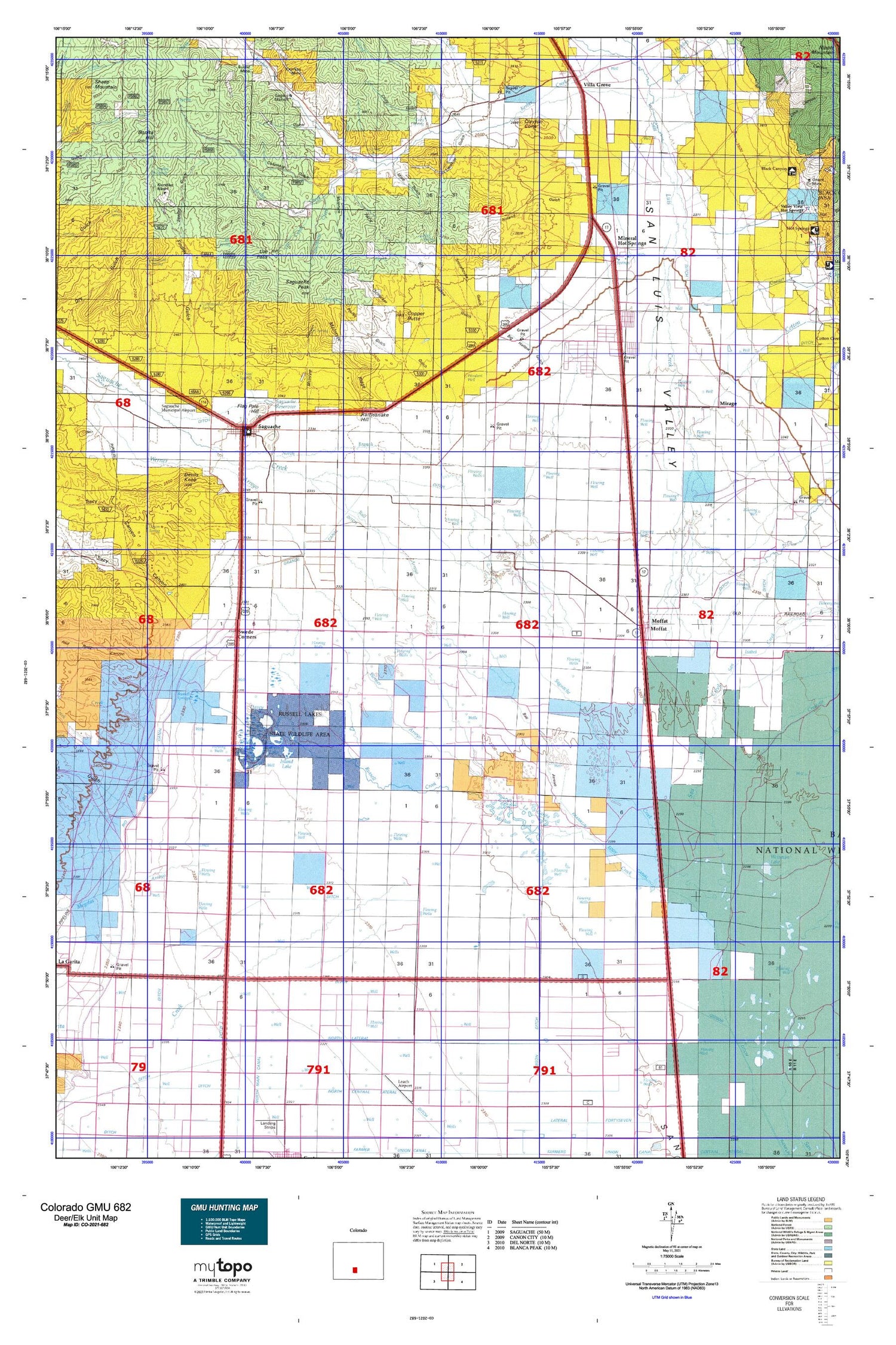
Colorado GMU 682 Map
Couldn't load pickup availability
Hunting unit map of Colorado Game Management Unit 682 with topographic lines and unit boundaries. This topo map features UTM / MGRS and Latitude/Longitude grids, plus public land ownership. It comes folded on waterproof paper. Be fully prepared for your hunt with a MyTopo GMU map!.
This map contains the following named places: 32 South Ditch,81125,81143,Alkali Spring,Asterhouse Gulch,Asterhouse Spring,Bachichi Spring,Ball Arroyo,Biedell Creek,Big Hollow Gulch,Big Meadow Ditch,Big Tree Gulch,Bonita,Bonita Hill,Braun Brothers Ditch Number 1,Campbell Ditch 5,Campbell Number 6,Carnero Creek,Church In the Valley,Clayton Cone,Cody Gulch,Cody Gulch Spring,Cody Spring,Coleman Cutoff Trail,Coleman South Ditch,Columbia Gulch,Columbia Spring,Community United Methodist Church,Copper Butte,Cotton Creek,Cotton Creek Cemetery,Cottonwood Creek,Cottonwood Spring,Crestone Creek,Crestone Ditch,Crow Drainage and Seepage Ditch,Davey Lake,De Tilla Gulch,Devils Knob,Drill Hole Gulch,E D Mine,Express Gulch,Findley Gulch,Findley Spring,Flagpole Hill,Free Spirit Christian Church,Garcia Spring,Garner Creek,Gibson Ditch,Gotthelf Samora Ditch,Graveyard Gulch,Greenback Gulch,Greyback Gulch,Harrence Lake,Hickey Bridge,Hillside Cemetery,Hoffman Niedhardt Ditch,Island Lake,Johnnie Smith Ditch Number 1,Johnson Lake,Kelly Creek,Kerber Creek Bog Iron Deposit Mine,Kimmel Lake,Klondike Mine,La Garita Creek,Lanier Ranch,Lawrence Ditch,Lime Canyon,Limekiln Gulch,Limekiln Spring,Little Kerber Creek,Lucky Boy Gulch,Major Creek,Malone Ditch,Manganese Gulch,McCormick Number 1 Dam,McCormick Number 1 Reservoir,McIntyre Canyon,McIntyre Gulch,McIntyre Ridge,McIntyre Spring,Meadow Ranch,Mine Gulch,Mineral Hot Springs,Mirage,Mirage Cemetery,Mishak Lakes,Moffat,Moffat Consolidated School,Moffat Fire Department,Moffat Post Office,Mogotas Arroyo,Mountain Valley School,Mud Spring,Noland Gulch,Noland Spring,North Branch Saguache Creek,North Ditch,North Lateral,North Saguache County Volunteer Department,North Tracy Canyon,O'Neal Spring,Onion Spring,Parkville,Pershing Mine,Phillips Ditch 1,Phillips Ditch 2,Piney Creek,Pitkkin Avenue Baptist Church,Proffit Gulch,Proffit Spring,Proffitt Company Ditch,Proffitt McDonough Ditch,Quartet Ditch,Rattlesnake Hill,Red Rock Canyon,Reservoir Enlargement Ditch,Rio Grande Canal,Rito Alto Creek,Roberts Company Ditch,Rock Spring,Rocky Hill Seepage Overflow Ditch,Russell Creek,Russell Ditch 4,Russell Lakes,Russell Springs,Sagauache County Comprehensive Health Clinic,Saguache,Saguache County Courthouse,Saguache County Jail,Saguache County Museum,Saguache County Sheriff's Office,Saguache Creek,Saguache Dam,Saguache District Ranger Office,Saguache Division,Saguache Emergency Management Services,Saguache Fire Department,Saguache Municipal Airport,Saguache Peak,Saguache Post Office,Saguache Reservoir,Saguache Town Hall,Saint Agnes Catholic Church Mission,San Isabel Creek,San Juan Creek,San Luis Company Ditch,Sand Gulch,Sanderson Gulch,Sanford Ditch,Sawlog Gulch,Sawmill Gulch,Schecker Gulch,Scheeker Spring,Schoolhouse Gulch,Schultze Dettrick Ditch,Seguache County Library,Seitz McClure Ashley Ditch,Shellabarger Ditch Number 2,Silver Creek,Soda Spring,Soda Spring Gulch,Spook City,Star Ditch,Steel Canyon,Stonehouse Gulch,Studhorse Creek,Swede Corners,Taylor Ashley Ditch,Tennessee Gulch,Town of Moffat,Town of Saguache,Tracy Canyon,Trites Lake,Tub Gulch,Turnbull Lunguen Ditch,U S Gulch,Ute Creek,Ute Pass,Ute Spring,Villa Grove,Villa Grove Fire Department,Villa Grove Post Office,Wales Shellabarger Ditch Number 1,Wales Travis Ditch,Weisman Lake,Wells Kerber Ditch,Werner Clark Ditch,White Ditch,Whites Cemetery,Wild Cherry Creek,Woodard Brothers Ditch,Woodard Cow Camp,Woodard Well