MyTopo
Colorado GMU 97 Map
Couldn't load pickup availability
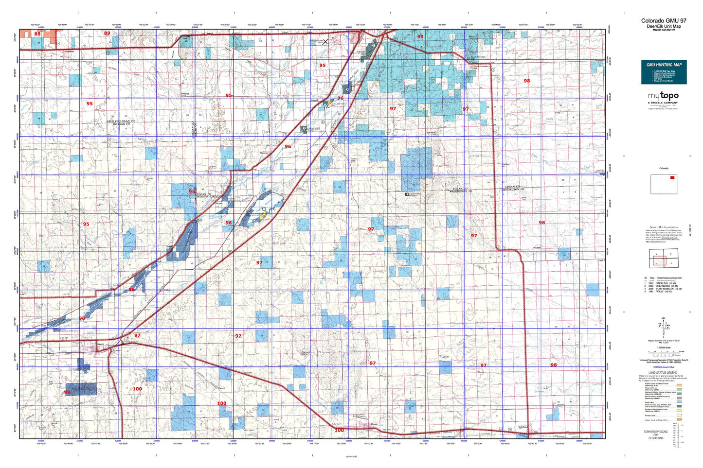
Hunting unit map of Colorado Game Management Unit 97 with topographic lines and unit boundaries. This topo map features UTM / MGRS and Latitude/Longitude grids, plus public land ownership. It comes folded on waterproof paper. Be fully prepared for your hunt with a MyTopo GMU map!.
This map contains the following named places: 80722,80723,80733,80741,80750,A-27 Dam,A-27 Reservoir,Akron Division,Antelope Draw,Antelope Springs,Antelope Springs Church,Atwood,Atwood Census Designated Place,Atwood Post Office,Badger Creek,Balzac,Batten Ditch,Beaver Creek,Beta,Brammer School,Brush,Brush City Police Department,Brush Division,Brush Golf Course,Brush Lateral,Brush Memorial Cemetery,Brush Municipal Airport,Brush Post Office,Brush Volunteer Fire Department,Buffalo Creek Dam,Buffalo Creek Reservoir,Buffalo Springs Ranch,Bunker Hill Country Club,Burdett Cemetery,Camden,Camp Creek,City of Brush,Colwell School,Company Ditch,Cooper,Costelloe Dam,Costelloe Reservoir,Curtis Cemetery,Davis Brothers Ditch,Dead Horse Draw,Dead Horse Springs,Dodd,Eagle Point Hill,East Akron Oil Field,East Morgan County Hospital,East Windmill,Eben Ezer Cemetery,Eben Ezer Lutheran Care Center,Emmerson Lake,Fairview School,Flying Y J Ranch,Fremont Butte,Fremont Butte Heliport,Fyffe School,Gebauer Airport,Gilliland School,Glacken Hill,Grave of Susanna Alderdice,Headley Dam,Headley Reservoir,High Plains Correctional Facility,Highland School,Hillrose,Hillrose - Snyder Fire Department,Hillrose Dairy,Hillrose Post Office,Hope Cemetery,J. L. Brush Memorial Cemetery,Jones Flat,Kelley Community Center,Kelly Community Cemetery,KJYY-FM (Brush),KKDD-FM (Brush),KKGZ-AM (Brush),KPMX-FM (Sterling),L F Draw,Lodi,Lower Platte and Beaver Canal,Lower Platte and Beaver Ditch,Merino,Merino Cemetery,Merino Division,Merino Oil Field,Merino Post Office,Merino Volunteer Fire Department,Messex,Midway,Miller Ranch,Mitchell Windmills,Moreland Windmill,Morey School,Nelson,North Buena Vista School,North Pawnee Ditch,North Schneider Ditch,North Sterling Canal,North Windmill,Old Black Tank Windmill,Pawnee Creek,Pawnee Ditch,Pawnee Evaporation Pond 1 2 and 3 Dam,Pawnee Evaporation Pond 1 2 and 3 Reservoir,Pawnee Raw Water Dam,Pawnee Raw Water Reservoir,Pinneo,Pinneo Feedlot,Prairie Lawn Cemetery,Prewitt Dam,Prewitt Inlet Canal,Prewitt Outlet Canal,Prewitt Reservoir,Riverside Ditch,Roosevelt School,Sand Hill Ditch,Schneider Ditch,School Section Windmill,Smith Lake,Snyder,Snyder Canal,Snyder Census Designated Place,Snyder Dam,Snyder Post Office,Snyder Reservoir,South Buena Vista School,South Platte Ditch,South Schneider Ditch,South Windmill,Summit Springs,Summit Springs Battlefield Cemetery,Summit Springs Battlefield Historical Marker,Tetsel Ditch,Tom Hoosier Mine,Town of Hillrose,Town of Merino,Tremont Canal,Trowel Ranch,Twentytwo Slough,Union,Union School,Upper Platte and Beaver Canal,Victory School,Wildcat Creek,Willard,Willard Fire Department