MyTopo
Big Bear Lake MyTopo Explorer Series Map
Couldn't load pickup availability
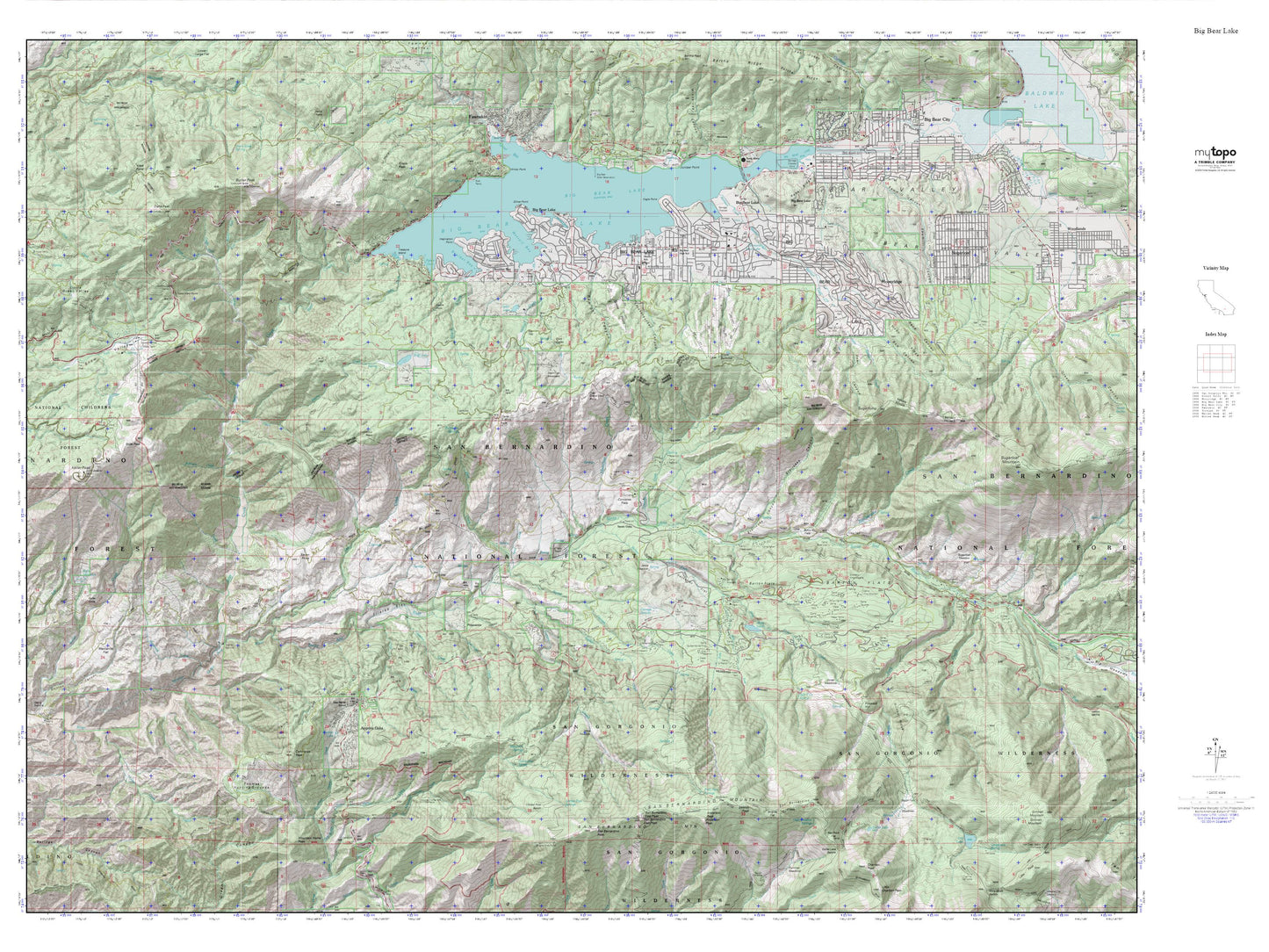
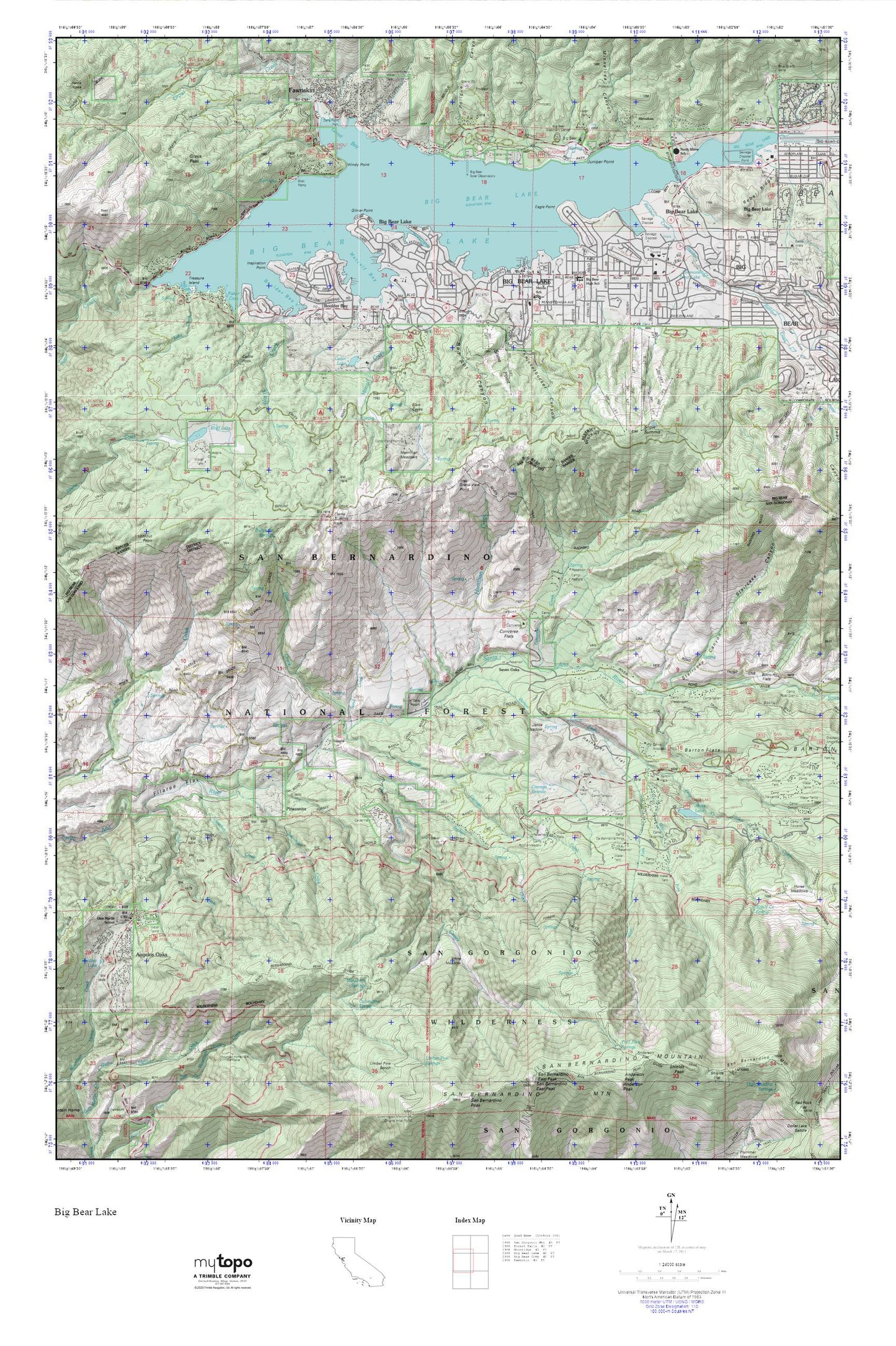
Topographic map of Big Bear Lake in the state of California. From the MyTopo Explorer Series.
This topo map features shaded relief and comes with UTM / MGRS and Latitude/Longitude grids.
For more than two decades, MyTopo has provided maps to the most adventurous among us.. those who love to explore our nation’s remote wilderness areas, climb our highest peaks, and trek across our vast public lands. This map is part of a curated collection of the most popular places for which MyTopo customers have designed maps. It is a “bucket list” of the most amazing places to hike, hunt, and explore.
This map contains the following named places: 92315,92333,Angelus Oaks,Angelus Oaks Post Office,Aspen Glen Picnic Area,Barton Creek,Barton Flats,Barton Flats Campground,Barton Flats Forest Service Station,Barton Flats Recreation Area,Bear Valley 2015 Dam,Bear Valley Community Hospital,Bellyache Springs,Berean Christian School,Big Bear Convention Center,Big Bear Dam,Big Bear Division,Big Bear Elementary School,Big Bear Lake,Big Bear Lake Branch San Bernardino County Library,Big Bear Lake Fire Protection District Boulder Bay Station,Big Bear Lake Fire Protection District Moonridge Station,Big Bear Lake Fire Protection District Station 281,Big Bear Lake Middle School,Big Bear Lake Police Department,Big Bear Lake Post Office,Big Bear Marina,Big Bear Ranger Station,Big Bear Solar Observatory,Bluff Lake,Boulder Bay,Burro Flats,Buttercup Campsite,Calvary Chapel Big Bear Christian School,Camp Akela,Camp Arbolado,Camp Cedar Falls,Camp Cohila,Camp De Benneville Pines,Camp Edwards,Camp JCA,Camp LaVerne,Camp Nawakwa,Camp Osito Rancho,Camp Radford,Camp River Glen,Camp Round Meadow,Camp Sky Meadow,Camp Ta Ta Pochon,Camp Tahquitz,Camp Tulake,Castle Rock,Cedar Lake,Cedar Lake 802 Dam,Cienaga Grande,City of Big Bear Lake,Clarks Ranch,Clarks Summit,Cold Creek,Coldbrook Campground,Columbine Spring,Converse Creek,Converse Flats,Converse Forest Service Station,Cougar Crest Trailhead,Council Campground,Deer Campsite,Eagle Point,East Boat Ramp,East Fork Barton Creek,East Landing,Eastwood Landing,Fawnskin,Fawnskin Community Church,Fawnskin Post Office,Filaree Flat,Fisher Cove,Forsee Creek,Forsee Creek Trail,Frog Creek,Gibralter Landing,Gibralter Point,Gilner Point,Glen Martin,Glen Martin 800 Dam,Glen Martin Elementary School,Gold Mine Golf Course,Gold Mine Ski Area,Grand View Point,Grays Landing,Grays Peak,Grout Bay,Grout Bay Campground,Grout Bay Recreation Area,Grout Creek,Hamilton Creek,Hathaway Flat,Holloways Camp,Horse Meadows,Inspiration Point,Interlaken Shopping Center,Jenks Lake,Jenks Lake Junction Recreation Area,Jenks Meadow,Johns Meadow,Juniper Point,Juniper Point Marina,KBBV-AM (Big Bear Lake),Kidd Cove,Kidd Creek,Kilpecker Creek,KTOT-FM (Big Bear Lake),Lagonita Point,Lakeview Shopping Center,Lighthouse Trailer Resort,Lookout Point,Mallard Lagoon,Manzanita Springs,Meadow Park,Meadows Edge Picnic Area,Merriman Meadows,Metcalf Bay,Metcalf Bay Landing,Metcalf Creek,Middle School,Mile Creek,Mile High Pines Camp,Minnelusa,Minnelusa Canyon,North Creek,North Shore Elementary School,North Shore Landing,North Shore Recreation Area,Oso-Lobo Campground,Pasadena Camp,Pine Knot Landing,Pine Knot Ranger Station,Pine Summit Conference Grounds,Pineknot Campground,Pinezanita,Pleasure Point Landing,Poligue Canyon,Promised Land Camp,Rathbun Creek,Rebel Ridge,Red Ant Canyon,Red Ant Landing,Round Cienaga Creek,San Bernardino County Fire Department Angelus Oaks Station 98,San Bernardino County Fire Department Station 96 Fawnskin,San Gorgonio Campground,San Y Ca Spring,Sand Creek,Sawmill Cove Landing,Schneider Creek,Serrano Campground,Seven Oaks,Seven Oaks Resort,Seven Oaks Trail,Shadow Lake,Shelter Cove,Simmons Trout Lake,Snow Forest Ski Area,Snow Point Canyon,Snow Summit,Snow Summit Ski Area,Staircase Canyon,Stetson Creek,The Pines,Treasure Island,Weesha Club,West Fork Barton Creek,West Public Boat Ramp,Windy Point,Woodland Trailhead