MyTopo
Mount Baldy MyTopo Explorer Series Map
Couldn't load pickup availability
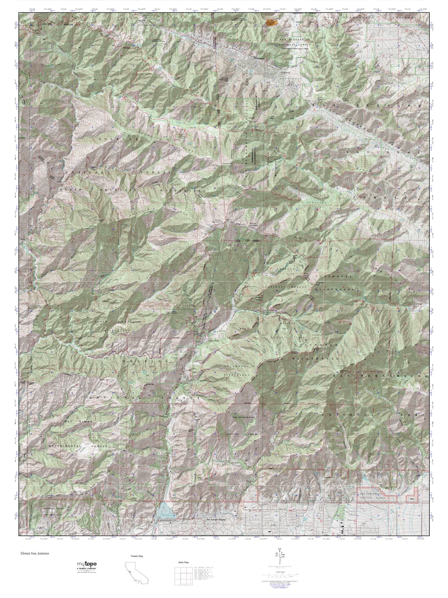
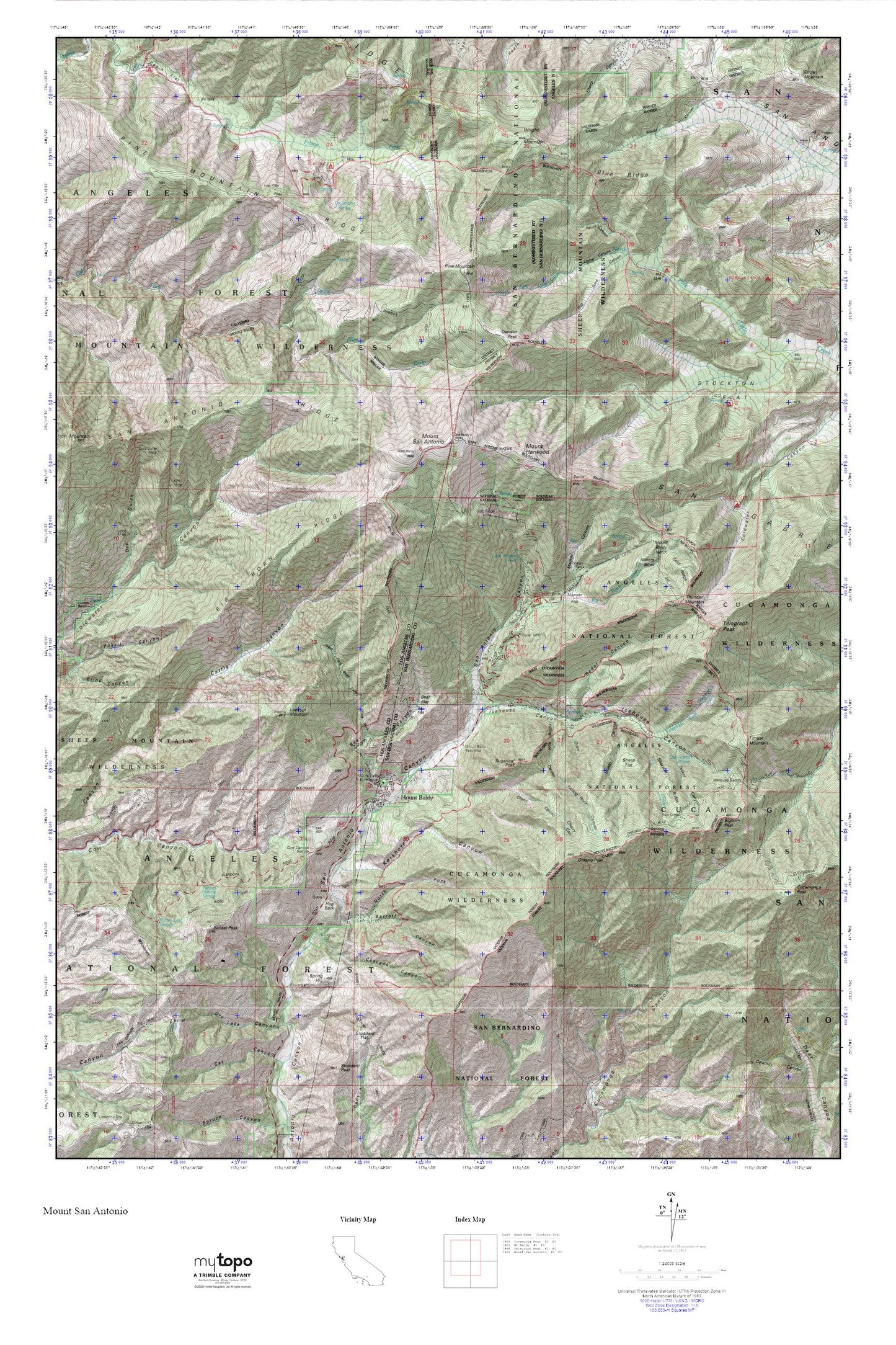
Topographic map of Mount Baldy in the state of California. From the MyTopo Explorer Series.
This topo map features shaded relief and comes with UTM / MGRS and Latitude/Longitude grids.
For more than two decades, MyTopo has provided maps to the most adventurous among us.. those who love to explore our nation’s remote wilderness areas, climb our highest peaks, and trek across our vast public lands. This map is part of a curated collection of the most popular places for which MyTopo customers have designed maps. It is a “bucket list” of the most amazing places to hike, hunt, and explore.
This map contains the following named places: 91759,Baldora Mine,Baldy Trail,Barrett Canyon,Bear Canyon,Bear Flat,Big Butch Wash,Big Horn Campground,Big Horn Ridge,Bighorn Peak,Blue Ridge,Cabin Flat,Camp Lupine,Camp San Antonio,Cascade Canyon,Cedar Canyon,Cherry Canyon,Coldwater Campground,Coldwater Canyon Truck Trail,Columbine Spring,Cow Canyon Saddle,Cucamonga Peak,Cucamonga Wilderness,Dawson Peak,Dawson Peak Trail,Delker Canyon,Dells,Devils Backbone,Dog Bone Canyon,Dry Gulch,Dry Lake Canyon,Eagle Mine,Fallen Leaf Spring,Falling Rock Canyon,Fern Canyon Trail,Fir Draw,Forked Spruce Spring,Glacier Camp,Glacier Picnic Area,Glacier Picnic Ground,Gold Dollar Mine,Gold Ridge,Gold Ridge Mine,Guffy Camp,Hog Back,Icehouse Canyon,Icehouse Saddle,Kelly Camp,Kerkoff Canyon,Lookout Mountain,Lost Creek,Manker Campground,Manker Canyon,Manker Flat,Miners Bowl,Mount Baldy,Mount Baldy Elementary School,Mount Baldy Forest Service Facility,Mount Baldy Notch,Mount Baldy Post Office,Mount Baldy Visitor Information Station,Mount Harwood,Mount San Antonio,Mt Baldy Post Office,Native Son Mine,North Fork Barrett Canyon,Ontario Peak,Ontario Peak Trail,Pauite Campground,Pine Mountain,Pine Mountain Ridge,Prairie Fork Guard Station,San Antonio Falls,San Antonio Ridge,San Bernardino County Fire Department Station 200 - Mount Baldly,San Gabriel Mountains,Sheep Canyon,Sheep Flat,Shortcut Ridge,Slover Canyon,Spring Hill,Stockton Flat,Stoddard Flat,Sugarloaf Peak,Sunset Peak,Sunset Peak Lookout,Telegraph Peak,Telegraph Wash,Thunder Mountain,Timber Mountain,Upper Lytle Creek Ridge,West Fork Bear Canyon,Widco Mine,Widman Ranch,Wright Mountain