
MyTopo
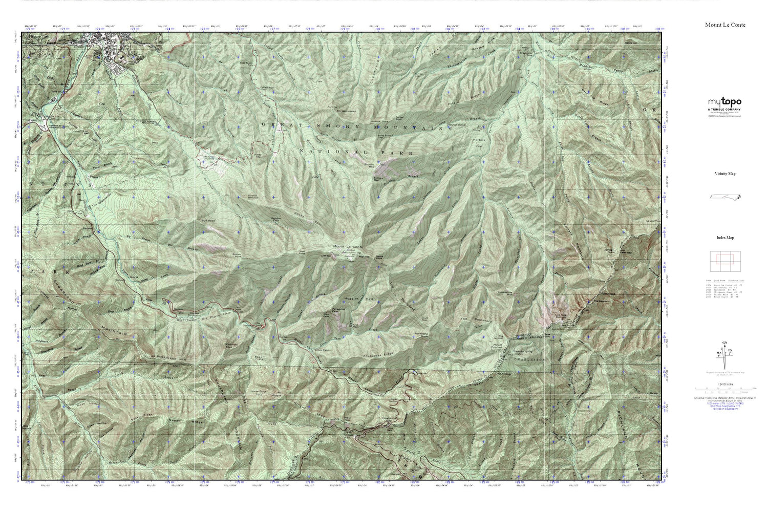
Mount Le Conte MyTopo Explorer Series Map
Couldn't load pickup availability
Topographic map of Mount Le Conte in the states of Tennessee, North Carolina. From the MyTopo Explorer Series.
This topo map features shaded relief and comes with UTM / MGRS and Latitude/Longitude grids.
For more than two decades, MyTopo has provided maps to the most adventurous among us.. those who love to explore our nation’s remote wilderness areas, climb our highest peaks, and trek across our vast public lands. This map is part of a curated collection of the most popular places for which MyTopo customers have designed maps. It is a “bucket list” of the most amazing places to hike, hunt, and explore.
This map contains the following named places: 37738,Alum Cave Creek,Alum Gap,Anakeesta Knob,Anakeesta Ridge,Arch Rock,Ash Hopper Branch,Bales Cemetery,Balsam Point,Baskins Creek Cemetery,Bearpen Hollow,Beech Flats,Big Branch,Boulevard Prong,Brushy Mountain,Bull Head,Bullhead Branch,Burton Ogle Cemetery,Cannon Creek,Carr Branch,Cataract Branch,Charlies Bunion,Cherokee Orchard,Chimney Tops,Chimneys Campground,Cliff Top,Cole Cemetery,Cole Creek,Commissioner District 11,Coon Branch,Critter Branch,Dead Hollow,Double Gourd Branch,Dry Pond Branch,Dry Sluice Gap,Enloe Hollow Branch,Ephraim Bales Place,Evans Chapel Cemetery,Falls Branch,Fighting Creek,First Branch,Fish Camp Prong,Fittified Spring,Flint Rock Branch,Fort Harry,Grapeyard Ridge,Grass Patch Branch,Grassy Patch,Grotto Falls,Groundhog Branch,Hant Hollow,Henderson Branch,Hickory King Branch,High Top,Horseshoe Branch,Horseshoe Mountain,Huff Cemetery,Huggins Hell,Hunter Creek,Huskey Gap,I N Trentham Cemetery,Icewater Spring,Icewater Spring Shelter,Indian Gap,Indian Grave Flats,Jim Carr Mill,Kalanu Prong,Kephart Shelter,Le Conte Lodge,Lester Prong,Little Goshen,Long Branch,Long Branch Gap,Lookout Rock,Lost Creek,Lower Fighting Creek Cemetery,Lower Grassy Branch,Lowes Creek,Luftee Gap,Masa Knob,Medicine Branch Bluff Campsite,Mellinger Cemetery,Mingus Lead,Moccasin Branch,Morton Overlook,Moss Hollow,Mount Ambler,Mount Kephart,Mount Le Conte,Mount LeConte Shelter,Mount Mingus,Mount Weaver,Mount Winnesoka,Myrtle Point,N S McCarter Cemetery,Newfound Gap,Old Sugarlands Cemetery,Ownby - Longbranch Cemetery,Peregrine Peak,Piney Mountain,Porters Flat,Porters Flat Campsite,Potato Ridge,Rainbow Falls,Ramp Creek,Rich Branch,Road Prong,Road Turn Branch,Rocky Spur,Rocky Spur Branch,Rough Creek,Rough Creek Campsite,Sawmill Branch,Scratch Britches,Second Branch,Shutts Prong,Split Branch,Spruce Flats Cemetery,Steep Branch,Styx Branch,Sugar Branch,Sugarland Branch,Sugarlands Utility Area,Sugarlands Visitor Center,Surry Fork,Sweat Heifer Creek,Sweet Ridge,The Boulevard,The Jumpoff,The Loop,The Sugarlands,Third Branch,Thirst Branch,Thomas Ridge,Tomahawk Prong,Trillium Branch,Trillium Gap,Trout Branch,Turkey Rock,Twin Creeks Government Headquarters,Twin Creeks Uplands Research Laboratory,Twomile Branch,Twomile Lead,Upper Grassy Branch,Vance Newman Cemetery,Walker Camp Prong,Watercrease Branch,West Point,Woolly Tops Branch


