MyTopo
Shining Rock MyTopo Explorer Series Map
Couldn't load pickup availability
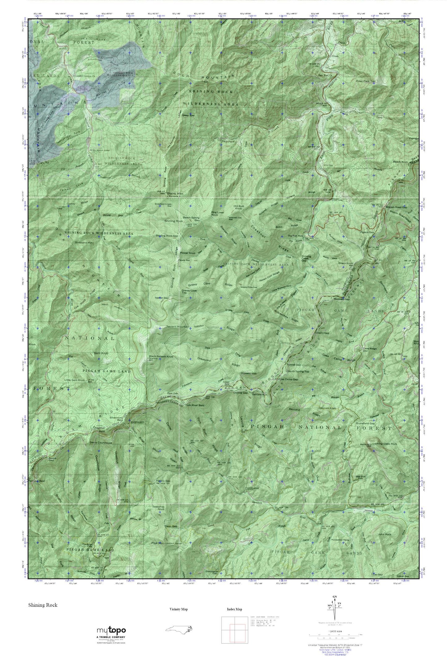
Topographic map of Shining Rock in the state of North Carolina. From the MyTopo Explorer Series.
This topo map features shaded relief and comes with UTM / MGRS and Latitude/Longitude grids.
For more than two decades, MyTopo has provided maps to the most adventurous among us.. those who love to explore our nation’s remote wilderness areas, climb our highest peaks, and trek across our vast public lands. This map is part of a curated collection of the most popular places for which MyTopo customers have designed maps. It is a “bucket list” of the most amazing places to hike, hunt, and explore.
This map contains the following named places: Bearpen Ridge,Bee Branch,Beech Gap,Beech Spring Gap,Bell Collar Cove,Bennett Branch,Bennett Cove,Bennett Gap,Bennett Knob,Big Bearpen Branch,Big Branch,Big Buckeye Cove,Big Cove,Big East Fork,Birdstand Mountain,Black Balsam Knob,Bobs Ridge,Bridges Camp Gap,Bubbling Spring Branch,Bullpen Cove,Camp Daniel Boone Dam,Camp Daniel Boone Lake,Camp Hope,Caney Bottom Creek,Case Camp Ridge,Case Ridge Gap,Cathey Cove,Cathey Ridge,Cecil,Cedar Rock Creek,Cherry Cove,Cherry Gap,Chestnut Bald,Chestnut Flat Cove,Chestnut Ridge,Coalney Branch,Cold Mountain,Courthouse Ridge,Cove Creek,Cove Creek Campground,Crawford Creek,Crawford Creek Gap,Cruso,Cruso Volunteer Fire Department,Daniel Boone Camp,Daniel Ridge,Daniel Ridge Creek,Daniels Cove,Dark Prong,Deep Gap,Deep Gap Cove,Devils Courthouse,Devil's Courthouse Tunnel,Dina Branch,Dog Loser Knob,Dry Branch,East Fork Baptist Church,Farlow Gap,Fate Osteen Cove,Fire Scald Ridge,Flat Laurel Creek,Flower Gap,Flower Knob,Fork Mountain,Fork River Bald,Fork River Ridge,Grassy Cove Gap,Grassy Cove Ridge,Grassy Cove Top,Graveyard Ridge,Greasy Cove Prong,Green Knob,Gumstand Branch,Gumstand Gap,Hemlock Branch,Hungry Creek,Ike Cove,Ivestor Gap,Ivestor Ridge,John Rock,Johns Cove,Justus Cove,Lanning Branch,Lanning Ridge,Laurel Fork,Laurel Grove Church,Little Buckeye Cove,Little Sam Knob,Log Hollow Branch,Long Branch,Looking Glass Rock,Looking Glass Rock Scenic Area,Murray Cove,Nobreechies Ridge,North Prong Shining Creek,Oaklog Gap,Old Butt Knob,Panther Branch,Pigeon Gap,Piney Field Top,Pisgah Creek,Pisgah Ridge,Poundingmill Branch,Raven Cliff Ridge,Right Fork Davidson River,Rockhouse Creek,Rocky Cove,Roland Ridge,Sam Branch,Sam Knob,Sassafras Knob,Scapecat Branch,Schoolhouse Branch,Second Falls,Seniard Mountain,Seniard Ridge,Shining Creek,Shining Creek Gap,Shining Rock,Shining Rock Creek,Shining Rock Gap,Shining Rock Ledge,Shining Rock Parking Area,Shining Rock Wilderness,Shuck Ridge,Shuck Ridge Creek,Silvermine Bald,Slick Rock Falls,Sliding Rock Recreation Site,Sorrell Creek,South Prong Shining Creek,South Spring Top,Spanish Oak Gap,Stairs Mountain,Tennent Mountain,The Narrows,Township of East Fork,Tunnel Gap,Ugly Creek,Upper Falls,Wagon Road Gap,Wagon Road Ridge,Wash Hollow,Yellowstone Falls,Yellowstone Prong