MyTopo
Neels Gap MyTopo Explorer Series Map
Couldn't load pickup availability
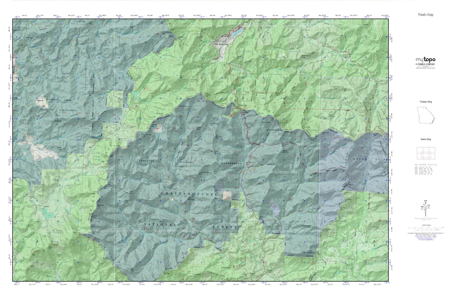
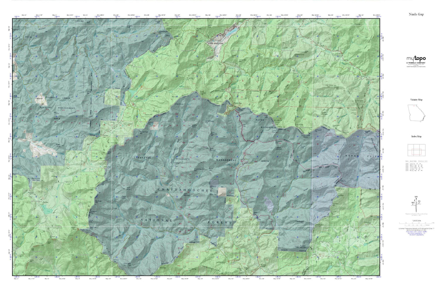
Topographic map of Neels Gap in the state of Georgia. From the MyTopo Explorer Series.
This topo map features shaded relief and comes with UTM / MGRS and Latitude/Longitude grids.
For more than two decades, MyTopo has provided maps to the most adventurous among us.. those who love to explore our nation’s remote wilderness areas, climb our highest peaks, and trek across our vast public lands. This map is part of a curated collection of the most popular places for which MyTopo customers have designed maps. It is a “bucket list” of the most amazing places to hike, hunt, and explore.
This map contains the following named places: Abe Mountain,Abercrombie Bald,Alex Cove,Augerhole Gap,Baggs Creek Gap,Baker Mountain,Bee Tree Ridge,Betty Cove Branch,Big Cedar Mountain,Big Ridge,Bird Gap,Black Mountain,Black Mountain Look Out Tower,Black Mountain Trail,Blood Mountain,Blood Mountain Cove,Blood Mountain Creek,Blood Mountain Wilderness,Blue Ridge Ranger Station,Brushy Knob,Bryant Creek,Buck Knob,Bull Gap,Burnett Creek,Burnett Field Mountain,Burnt Ridge,Buzzard Mountain,Buzzard Rock Ridge,Cedar Mountain,Chestatee Knoll Campground,Chestatee Wildlife Management Area,Chester Stamp Gap,Chestnut Cove Gap,Chestnut Flats,Chestnut Knob,Columbia Creek,Corbin Horse Stamp,Corinth Church,Cowrock Creek,Crow Mountain,Cynthia Knob,Dan Gap,Daniel Camp Gap,Davis Mountain,DeSoto Falls,DeSoto Falls Recreation Area,DeSoto Falls Scenic Area,DeSoto Falls Trail,Dicks Creek,Dockery Lake,Dockery Lake Campground,Dockery Lake Dam,Dollar Lake,Dollar Lake Dam,Dug Gap,East Seabolt Creek,Fisher Knob,Flatlands,Flatrock Gap,Flowers Cove,Flowers Cove Branch,Frogtown Cove,Frogtown Creek,Gaddis Mountain,Garrett Creek,Gooch Gap,Granny Top,Grassy Gap Branch,Ground Squirrel Gap,Gum Gap School,Harmony Church,Harmony Springs,Hatchet Creek,Helton Creek,Helton Creek Falls,Henry Gap,Hester Gap,High Valley Airpark,High Water Falls,Hogpen Branch,Hogpen Mountain,Horsebone Gap,Jacks Gap,Jacobs Knob,Jarrard Creek,Jarrard Gap,Jim Cove,Kennedy Creek,Lake Winfield Scott,Lake Winfield Scott Campground,Lake Winfield Scott Dam,Lance Branch,Lance Creek,Lark Gap,Levelland Cove,Levelland Mountain,Liss Gap,Little Buzzard Mountain,Little Cedar Mountain,Little Ridge,Little Wildcat Mountain,Locust Gap,Logan Creek,Lunsford Gap,Meadow Gap,Middle Ridge,Miller Creek,Miller Gap,Miller Top,Mount Lebanon Cemetery,Mount Lebanon Church,Mount Lebanon School,Mount Zion Church,Muddy Branch,Nance Payne Cove,Nance Ridge,Neels Gap,Noah Branch,Nottely Falls,Panther Gap,Pigeon Roost,Pigeon Roost Creek,Quebec,Quebec Branch,Ramrock Mountain,Reece State Memorial,Richland Creek,Rock Spring Top,Rocky Mountain,Rough Mountain,Sarah,Shanty Branch,Sheep Knob,Shellot Cliffs,Shingle Mill Gap,Slaughter Creek,Slaughter Gap,Slaughter Mountain,South Fork Baker Branch,Spriggs Cemetery,Steel Trap Knob,Suches,Suches Post Office,Swaim Cove,Swaim Gap,Tom Field Gap,Trail Ridge,Tritt Gap,Turkey Creek,Turkey Stamp,Turkeypen Gap,Turkeypen Mountain,Twomile Gap,Union County Fire Department Station 5,Vogel State Park,Walnut,Waters Creek,West Seabolt Creek,Wildcat Gap,Will Field Gap,Wolf Laurel Top,Woody Cemetery,Woody Gap,Woody Gap Campground,Woody Gap Elementary School,Woody Gap School,Woody Lake,Woody Lake Dam,Y J Gap,Yellow Mountain,Yellow Mountain Gap,Zion School