
MyTopo
Cades Cove MyTopo Explorer Series Map
Couldn't load pickup availability
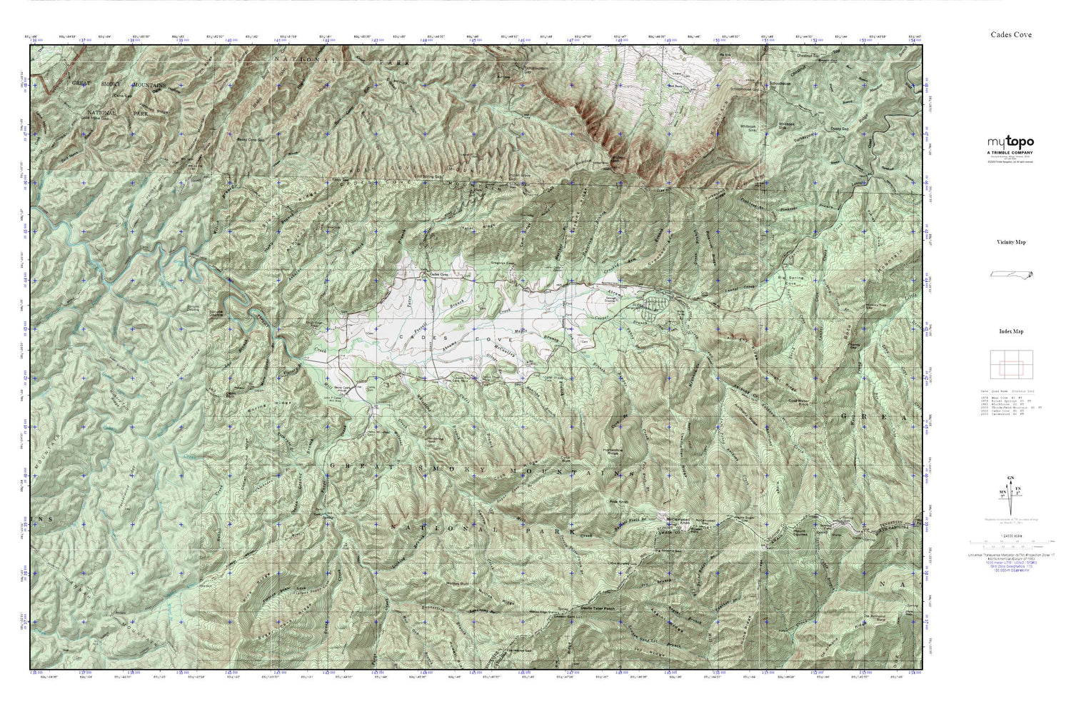
Topographic map of Cades Cove in the states of Tennessee, North Carolina. From the MyTopo Explorer Series.
This topo map features shaded relief and comes with UTM / MGRS and Latitude/Longitude grids.
For more than two decades, MyTopo has provided maps to the most adventurous among us.. those who love to explore our nation’s remote wilderness areas, climb our highest peaks, and trek across our vast public lands. This map is part of a curated collection of the most popular places for which MyTopo customers have designed maps. It is a “bucket list” of the most amazing places to hike, hunt, and explore.
This map contains the following named places: 37878,37882,Abrams Falls,Abrams Falls Trail,Allnight Ridge,Andy McCully Branch,Andy McCully Ridge,Anthony Creek,Anthony Creek Campsite,Anthony Creek Horse Camp,Anthony Creek Trail,Anthony Ridge,Arbutus Branch,Arbutus Ridge,Asgini Ridge,Beard Cane Campsite,Beard Cane Gap,Bearpen Ridge,Becky Cable House,Bell Cove Branch,Big Abrams Gap,Big Grill Ridge,Big Spring Cove,Boring Cemetery,Boring Ridge,Bower Creek,Browns Hill Cemetery,Buck Shank Branch,Bunting Branch,Burnt Ridge Branch,Cable Cemetery,Cable School,Cades Branch,Cades Cove,Cades Cove Bloomery Forge,Cades Cove Campground,Cades Cove Group Campground,Cades Cove Methodist Church,Cades Cove Methodist Church Cemetery,Cades Cove Missionary Baptist Church,Cades Cove Missionary Baptist Church Cemetery,Cades Cove Mountain,Cades Cove Primitive Baptist Church,Cades Cove Primitive Baptist Church Cemetery,Cades Cove Visitor Center,Carter Shields Place,Carver - Feezell Cemetery,Cave Ridge,Cerulean Knob,Chickadee Branch,Coalen Ground Branch,Coalen Ground Ridge,Cobb Butt,Cobb Ridge,Cold Spring Gap,Cold Water Knob,Coon Butt,Cooper Branch,Cork Branch,Crib Gap,Crooked Arm,Crooked Arm Branch,Crooked Ridge,Davis Cemetery,Devils Tater Patch,Devils Tater Patch Branch,Double Mountain,Double Mountain Campsite,Ekaneetlee Branch,Elijah Oliver Place,Fanny Branch,Feezell Branch,Forge Creek,Gold Mine Gap,Graveyard Hill - Rowans Cemetery,Green Branch,Hannah Branch,Hannah Mountain,Hannah Mountain Trail,Harrison Branch,Henry Whitehead Cabin,Hickory Turn Branch,Hickory Turn Ridge,Horseshoe Ridge,Hyatt Lane Church Cemetery,Ike Lequire Cemetery,Incline Gap,Indian Grave Gap,Ivy Branch,John Oliver Cabin,John P Cable Mill Area,Johnnys Ridge,Kreider Branch,Laurel Cove Creek,Law Branch,Lawson Cemetery,Lawson Gant Lot,Leadbetter Ridge,Leading Ridge,Ledbetter Ridge Campsite,Left Prong Anthony Creek,Licklog Branch,Little Abrams Gap,Little Bald,Little Bottom Campsite,Little Bottoms Trail,Lonesome Branch,Lynn Hollow,Maple Branch,Maple Sugar Gap,Marthas Branch,Maynard Creek,McCampbell Gap,McCampbell Knob,McCaulley Branch,McCully Branch,Mill Branch,Mill Creek,Mink Branch,Mollies Butt,Mollies Ridge,Mollies Ridge Shelter,More Licker Branch,Mount Lanier,Mount Squires,Mud Gap Branch,Narrow Creek,Noah Burchfield Cemetery,Nuna Ridge,Oak Flats Branch,Oliver Branch,Panther Branch,Peckerwood Branch,Peckerwood Ridge,Peter Cable Place,Pine Oak Trail,Pinkroot Ridge,Pole Knob,Pole Knob Branch,Polecat Branch,Post Cemetery,Rabbit Creek,Rabbit Creek Campsite,Rich Mountain,Rich Mountain Trail,Rowans Creek,Russell Field,Russell Field Branch,Russell Field Shelter,Russell Field Trail,Scott Gap,Scott Gap Branch,Scott Mountain,Sea Branch,Spruce Double,Spruce Double Branch,Stickbait Branch,Stillhouse Branch,Stony Branch,Stony Gap,Stony Ridge,Sugar Cove Branch,Sugar Cove Prong,Tater Branch,Tater Ridge,Tipton Oliver Place,Tiptons Sugar Cove,Tiptons Sugar Cove Branch,Titmouse Branch,Turkey Pen Ridge Campsite,Turkeypen Ridge,Victory Branch,Vista Trail,Weasel Branch,Wedge Ridge,Whistling Branch,Whistling Gap,White Oaks Sinks Cemetery,Whiteoak Sink,Wildcat Branch,Wilson Branch


