MyTopo
Wichita Mountains MyTopo Explorer Series Map
Couldn't load pickup availability
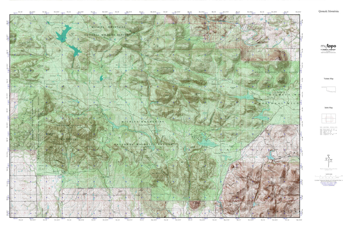
Topographic map of Wichita Mountains in the state of Oklahoma. From the MyTopo Explorer Series.
This topo map features shaded relief and comes with UTM / MGRS and Latitude/Longitude grids.
For more than two decades, MyTopo has provided maps to the most adventurous among us.. those who love to explore our nation’s remote wilderness areas, climb our highest peaks, and trek across our vast public lands. This map is part of a curated collection of the most popular places for which MyTopo customers have designed maps. It is a “bucket list” of the most amazing places to hike, hunt, and explore.
This map contains the following named places: Antelope Flat,Apache Lake,Arapaho Point,Bad Lands,Bat Cave Mountain,Big Bull Pasture,Big Four Mountain,Black Bear Mountain,Black Bear Spring,Bonanza Mine,Boulder Camp,Boulder Field,Boulder Turnoff,Broken Hills,Buffalo Gap,Burford Lake,Burford Lake Dam,Bushman Mountain,Cache Wye,Caddo Lake,Caddo Lake Dam,Cedar Mountain,Centennial Arch,Central Peak,Charons Garden Mountains,Comanche Lake,Comanche Lake Dam,Cottonwood Spring,Cow Creek,Crater Lake,Crater Lake Dam,Dead Man Mountain,Deer Creek,Dog Run Hollow,Doris Campground,Eagle Mountain,East Fork Quanah Creek,Elk Mountain,Elk Pass,Exhibition Pasture,Fawn Creek,Fern Mountain,Fish Lakes,Forty Foot Hole,French Lake,French Lake Dam,Graham Flat,Gramma Lake Dam,Granite Mountain,Gray Wolf Crossing,Gray Wolf Spring,Greenleaf Canyon,Hackney Spring,Headquarters Creek,Hollis Canyon,Indiahoma Wye,Indian Hill,Jed Johnston Lake Dam,Kiowa Lake,Kiowa Lake Dam,Lake Jed Johnson,Lake Rush,Little Baldy,Lost Lake,Lost Lake Dam,Moko Mountain,Mount Lauramac,Mount Lincoln,Mount Marcy,Mount McKinley,Official Dog Town,Osage Lake,Panther Creek,Pennington Mine,Phantom Mountain,Poko Mountain,Post Oak Lake,Post Oak Lake Dam,Quanah Mountain,Quanah Parker Lake,Quanah Parker Lake Dam,Quanah Parker Lake Visitor Center,Rush Lake Dam,Soldiers Dam,Spanish Canyon,Styx Canyon,Sulphur Flat,Sun Set Pool,Sunset Peak,Tarbone Mountain,The Narrows,Timber Hill,Treasure Lake,Treasure Lake Civilian Conservation Center,Turkey Creek,Turkey Pass,Turtle Springs,Twin Rocks Mountain,Wells Flat,Wells Flats,West Fork Quanah Creek,Wichita Mountains,Wichita Mountains National Wildlife Refuge Headquarters,Wichita Mountains Wilderness (Charons Garden Unit),Wichita Mountains Wildlife Refuge,Wild Horse Canyon,Winborn Spring,Winter Valley,Yshua Sports Camp