MyTopo
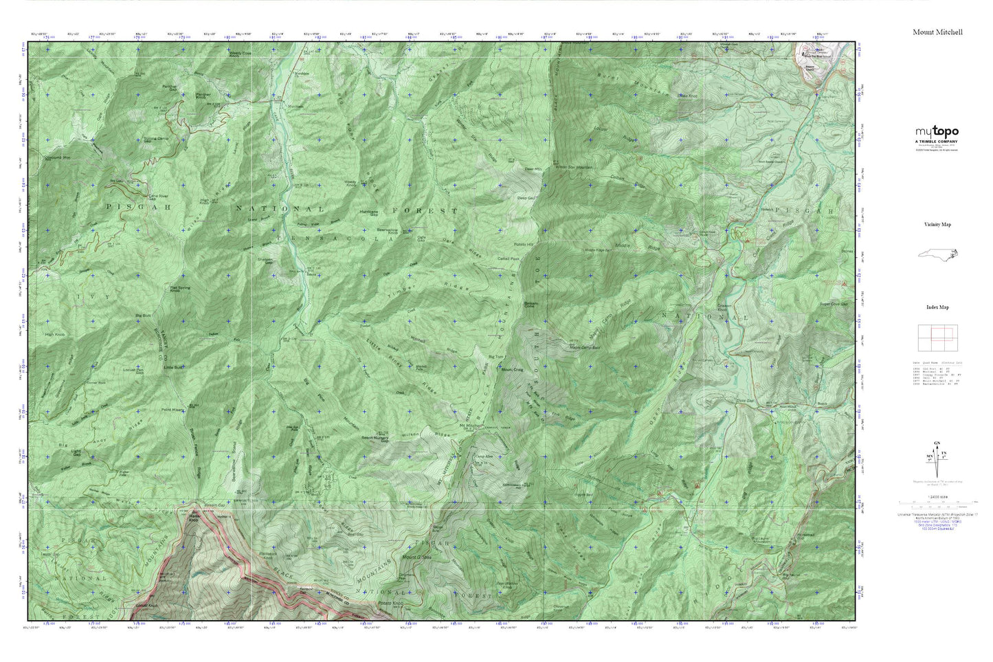
Mount Mitchell MyTopo Explorer Series Map
Couldn't load pickup availability
Topographic map of Mount Mitchell in the state of North Carolina. From the MyTopo Explorer Series.
This topo map features shaded relief and comes with UTM / MGRS and Latitude/Longitude grids.
For more than two decades, MyTopo has provided maps to the most adventurous among us.. those who love to explore our nation’s remote wilderness areas, climb our highest peaks, and trek across our vast public lands. This map is part of a curated collection of the most popular places for which MyTopo customers have designed maps. It is a “bucket list” of the most amazing places to hike, hunt, and explore.
This map contains the following named places: Allen Cemetery,Balsam Cone,Balsam Gap,Bear Gap,Bear Ridge,Bear Wallow Knob,Bearwallow Knob,Bearwallow Ridge,Bearwallow Stand Ridge,Beech Nursery Creek,Beech Nursery Gap,Big Andy Ridge,Big Butt,Big Fork Ridge,Big Laurel Mountain,Big Lost Cove Creek,Big Pine Mountain,Big Poplar Creek,Big Ridge,Big Tom,Bill Autrey Branch,Black Mountain Campground,Black Mountains,Black Ridge,Blackstock Knob,Blue Ridge,Blue Sea Creek,Blue Sea Falls,Briar Bottom Recreation Area,Brush Fence Ridge,Camp Alice,Camp Creek,Cane River Gap,Carolina Hemlocks Recreation Area,Cattail Creek Community,Cattail Peak,Cherry Mountain,Clear Creek,Clingmans Peak,Colbert Creek,Colbert Creek Church,Colbert Ridge,Commissary Hill,Commissary Ridge,Corner Rock,Corner Rock Picnic Area,Coxcomb Mountain,Crisawn Cemetery,Crisawn Knob,Deep Gap,Deer Mountain,Dicks Gap,Eskota,Falling Water Branch,Flat Spring Knob,Flynn Ridge,Fork Ridge,Glassmine Ridge,Grassy Knob Ridge,Hallback,Hamrick,Higgins Bald,High Knob,Hurricane Gap,Indian Fork,Ivy Gap,Ivy Knob,John Autrey Branch,Laurel Branch,Laurel Gap,Laurel Ridge,Light Gap,Little Andy Creek,Little Butt,Little Mountain,Little Mountain Creek,Little Piney Ridge,Locust Pen Gap,Locust Ridge,Long Arm Ridge,Lost Cove Picnic Area,Maple Bald Creek,Maple Camp Bald,Maple Camp Creek,Maple Camp Ridge,Middle Creek,Middle Fork Rock Creek,Middle Ridge,Middle Ridge Bald,Mitchell Creek,Mitchell Falls,Mitchell Ridge,Mount Craig,Mount Gibbes,Mount Mitchell,Mount Mitchell State Park,Neals Creek,Neals Creek Heliport,North Fork Cattail Creek,North Fork Rock Creek,Ogle Branch,Ogle Creek,Ogle Gap,Ogle Meadows,Ogle Ridge,Open Ridge,Pigpen Knob,Pisgah National Forest,Point Misery,Potato Hill,Raven Fork,Right Prong Clear Creek,Robinson Cemetery,Rock Creek,Rolling Camp Gap,Setrock Creek,Shateen Branch,Shateen Gap,Simmons Cemetery,South Fork Cattail Creek,Staire Branch,Stepps Gap,Still Fork Creek,Straight Creek,Sugarcamp Creek,Sugarhouse Cove,Tharp Mountain,Thee Creek,Timber Creek,Timber Ridge,Township of Pensacola,Township of South Toe,Walker Falls,Walker Knob,Walker Ridge,Weedy Knob,Westall Cemetery,Wheeler Cemetery,Whiteside Ridge,Wilson Ridge,Winter Star Mountain,Winter Star Ridge,WMIT-FM (Black Mountain)