
MyTopo
Allenspark MyTopo Explorer Series Map
Couldn't load pickup availability
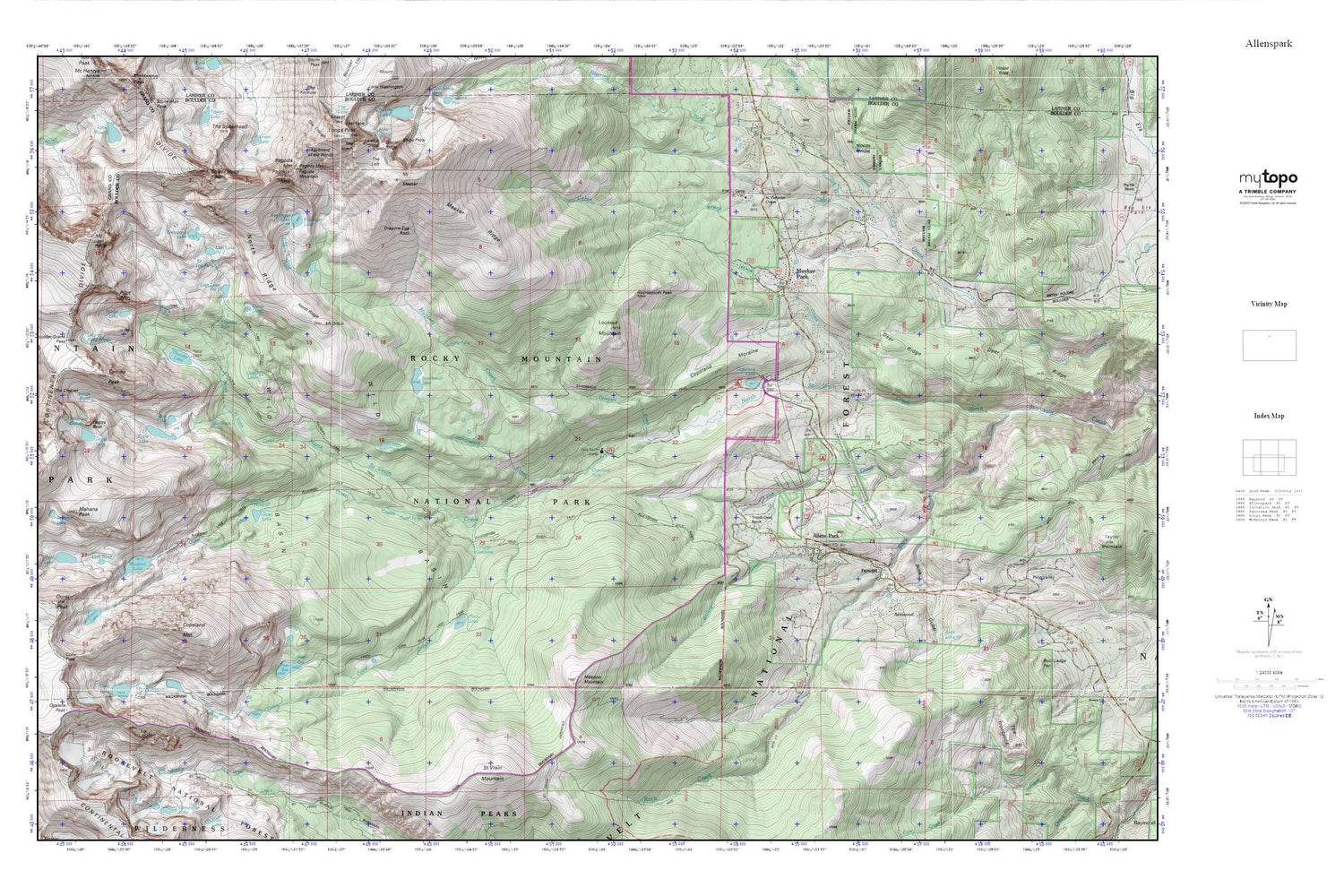
Topographic map of Allenspark in the state of Colorado. From the MyTopo Explorer Series.
This topo map features shaded relief and comes with UTM / MGRS and Latitude/Longitude grids.
For more than two decades, MyTopo has provided maps to the most adventurous among us.. those who love to explore our nation’s remote wilderness areas, climb our highest peaks, and trek across our vast public lands. This map is part of a curated collection of the most popular places for which MyTopo customers have designed maps. It is a “bucket list” of the most amazing places to hike, hunt, and explore.
This map contains the following named places: 80510,Allens Park Trail,Allens Park-Wild Basin Trail,Allenspark,Allenspark Census Designated Place,Allenspark Fire Department Station 1,Allenspark Fire Department Station 3 - Meeker Park,Allenspark Post Office,Arrowood,Bluebird Dam,Bluebird Lake,Bluebird Lake Trail,Boulder-Grand Pass,Box Lake,Buck Gulch,Buck Lake,Calypso Cascades,Camp Saint Malo,Campers Creek,Castle Lake,Castle Lakes,Chickadee Pond,Chiefs Head Peak,Cony Creek,Cony Lake,Cony Pass,Copeland Dam,Copeland Falls,Copeland Lake,Copeland Moraine,Copeland Mountain,Deer Ridge,Dragons Egg Rock,Eagle Lake,Eagles Beak,Elk Tooth,Falcon Lake,Fan Falls,Fawn Creek,Ferncliff,Finch Lake,Finch Lake-Pear Reservoir Trail,Fox Creek,Frigid Lake,Hidden Brook,Horse Creek,Horsetooth Peak,Hunters Creek,Hutcheson Lakes,Indigo Pond,Isolation Lake,Junco Lake,Keplinger Lake,Keyboard of the Winds,Lake of Many Winds,Lark Pond,Lion Lake Number 1,Lion Lake Number 2,Lion Lake Trail,Lookout Mountain,Lyric Falls,Mahana Peak,Meadow Mountain,Meeker Park,Meeker Park Campground,Meeker Ridge,Mertensia Falls,Moomaw Glacier,Mount Alice,Mount Meeker,Mount Meeker Campground,Mount Orton,North Ridge,Ogalalla Peak,Olive Ridge Campground,Ouzel Creek,Ouzel Falls,Ouzel Lake,Ouzel Peak,Pagoda Mountain,Pear Dam,Pear Reservoir,Pilot Mountain,Pipit Lake,Roaring Fork,Rock Creek Ski Area,Saint Catherine Chapel,Saint Vrain Glaciers,Saint Vrain Mountain,Saint Vrain Mountain Trail,Sand Beach Dam,Sandbeach Creek,Sandbeach Lake,Sandbeach Lake Trail,Snowbank Lake,Tahosa Creek,Tahosa Valley,Tanima Peak,Tent Rocks,The Cleaver,The Loft,Thunder Falls,Thunder Lake,Thunder Lake Trail,Trio Falls,Triple Creek Ranch,Twin Lakes,Twin Sister Mine,Upper Saint Vrain Division,Wild Basin,Wild Basin Ranger Station,Willow Creek


