MyTopo
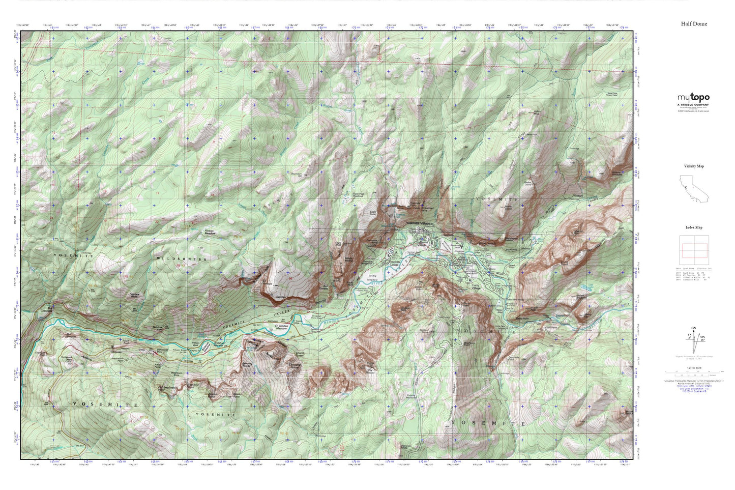
Yosemite National Park_The North Rim MyTopo Explorer Series Map
Couldn't load pickup availability
Topographic map of Yosemite National Park_The North Rim in the state of California. From the MyTopo Explorer Series.
This topo map features shaded relief and comes with UTM / MGRS and Latitude/Longitude grids.
For more than two decades, MyTopo has provided maps to the most adventurous among us.. those who love to explore our nation’s remote wilderness areas, climb our highest peaks, and trek across our vast public lands. This map is part of a curated collection of the most popular places for which MyTopo customers have designed maps. It is a “bucket list” of the most amazing places to hike, hunt, and explore.
This map contains the following named places: Ahwahnee Bridge,Ahwahnee Meadow,Arrowhead Spire,Artist Creek,Artist Point,Basket Dome,Black Spring,Bluejay Creek,Boundary Hill,Bridalveil Creek,Bridalveil Fall,Bridalveil Meadow,Bridalveil Moraine,Buena Vista Trail,Camp Curry Historic District,Camp Curry Post Office,Cascade Creek,Cascade Dam,Castle Cliffs,Cathedral Beach Picnic Area,Cathedral Rocks,Cathedral Spires,Church Tower,Clark Point,Clarks Bridge,Columbia Rock,Coyote Creek,Crocker Point,Curry Village,Curry Village Post Office,Delaware North Company Fire Department Yosemite,Dewey Point,Discovery View,Eagle Creek,Eagle Peak,Eagle Peak Creek,Eagle Peak Meadows,Eagle Peak Trail,Eagle Tower,El Capitan,El Capitan Bridge,El Capitan Gully,El Capitan Meadow,El Capitan Moraine,El Capitan Picnic Area,El Capitan Trail,Elephant Rock,Fern Spring,Fireplace Bluffs,Fireplace Creek,Fort Monroe,Four Mile Trail,Glacier Point,Grizzly Peak,Group Camp,Gunsight,Happy Isles,Happy Isles Bridge,Hetch Hetchy Trail,Housekeeping Camp,Illilouette Creek,Illilouette Falls,Illilouette Gorge,Illilouette Ridge,Indian Canyon,Indian Canyon Creek,Indian Ridge,Indian Rock,Inspiration Point,Iron Spring,K P Pinnacle,Leaning Tower,Leconte Memorial Lodge,Lehamite Creek,Lehamite Falls,Leidig Meadow,Lost Arrow,Lower Brother,Lower Pines Campground,Lower River Campground,Lower Yosemite Fall,Meadow Brook,Medial Moraine,Merced Wild and Scenic River,Middle Brother,Mirror Lake,Mist Trail,Moran Point,Moss Spring,North Dome,North Dome Trail,North Pines Campground,Old Inspiration Point,Panorama Cliff,Panorama Point,Panorama Trail,Pohono Bridge,Pohono Trail,Pothole Meadows,Profile Cliff,Pulpit Rock,Rainbow View,Rangers' Club,Ribbon Creek,Ribbon Fall,Ribbon Meadow,Rockslides,Rocky Point,Roosevelt Point,Royal Arch Cascade,Royal Arch Creek,Royal Arches,Sentinel Beach Picnic Area,Sentinel Bridge,Sentinel Creek,Sentinel Dome,Sentinel Fall,Sentinel Rock,Sierra Point,Silver Strand Falls,Split Pinnacle,Staircase Falls,Stanford Point,Stoneman Bridge,Stoneman Meadow,Sugar Pine Bridge,Sunnyside Campground,Taft Point,Tamarack Creek,Tenaya Bridge,Tenaya Canyon,Tenaya Creek,The Ahwahnee,The Cascades,The Fissures,The Gateway,The Rostrum,Three Brothers,Turtleback Dome,Union Point,Upper Pines Campground,Upper River Campground,Upper Yosemite Falls,Valley View,Vernal Fall,Washburn Point,Washburn Slide,Washington Column,Wawona Tunnel,Wildcat Creek,Wildcat Falls,Yosemite Creek,Yosemite Falls,Yosemite Falls Trail,Yosemite Lodge,Yosemite Lodge Post Office,Yosemite National Park Post Office,Yosemite National Park Valley Elementary School,Yosemite Pioneer Cemetery,Yosemite Point,Yosemite Valley,Yosemite Valley Census Designated Place,Yosemite Valley Division,Yosemite Village