MyTopo
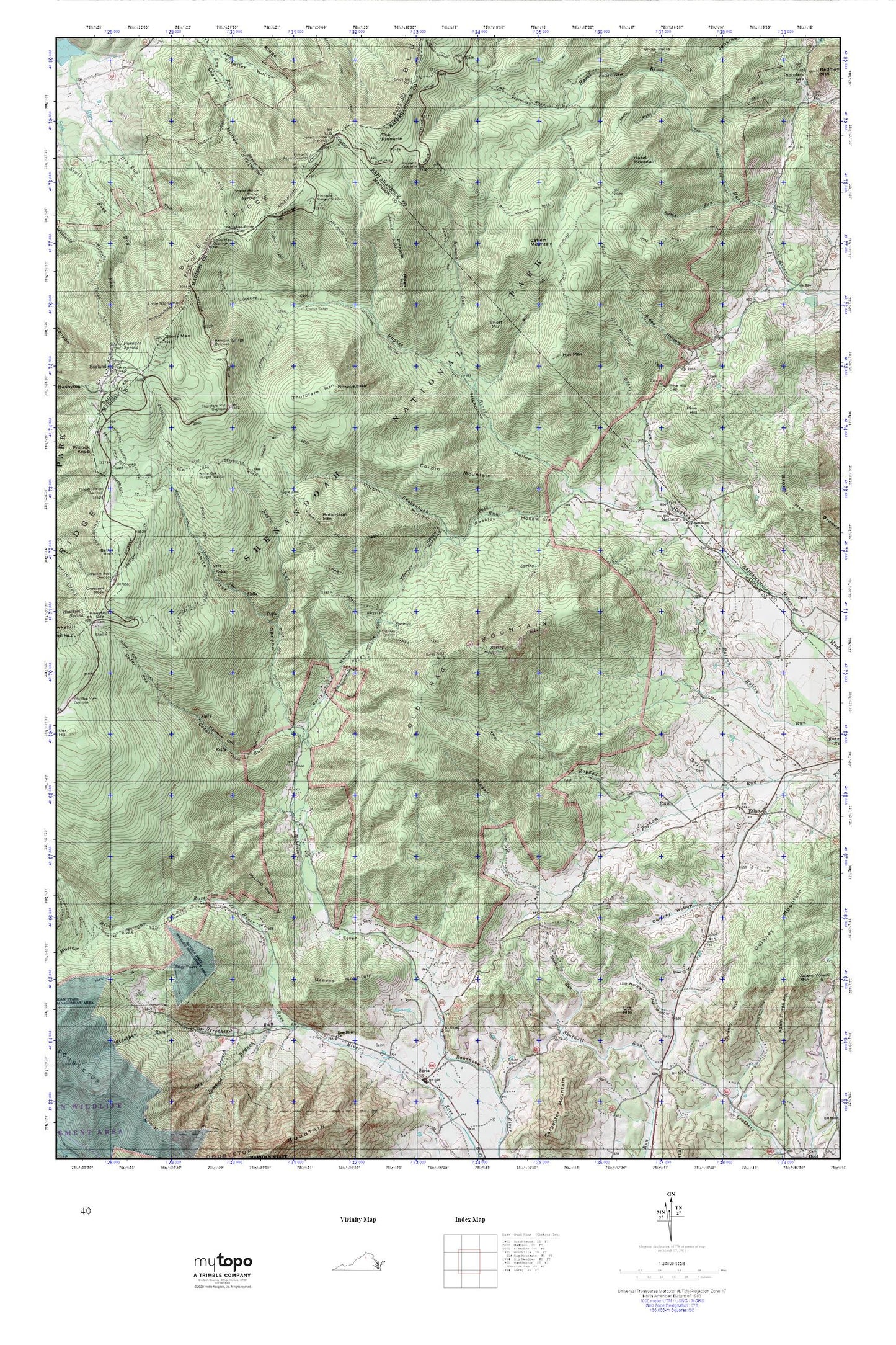
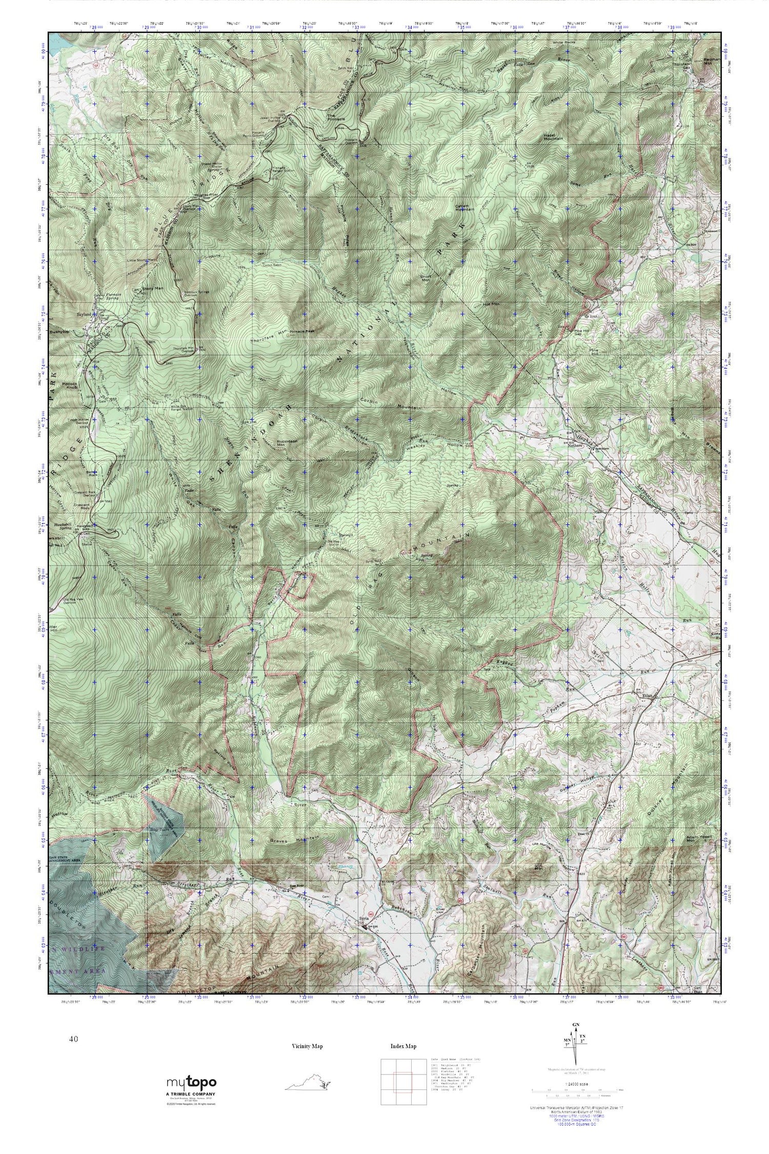
Old Rag Mountain MyTopo Explorer Series Map
Couldn't load pickup availability
Topographic map of Old Rag Mountain in the state of Virginia. From the MyTopo Explorer Series.
This topo map features shaded relief and comes with UTM / MGRS and Latitude/Longitude grids.
For more than two decades, MyTopo has provided maps to the most adventurous among us.. those who love to explore our nation’s remote wilderness areas, climb our highest peaks, and trek across our vast public lands. This map is part of a curated collection of the most popular places for which MyTopo customers have designed maps. It is a “bucket list” of the most amazing places to hike, hunt, and explore.
This map contains the following named places: 22719,22743,Aaron Nicholson House,Aarons Branch,Adam Yowell Mountain,Berry Hollow,Bethlehem United Methodist Church,Bettys Rock,Big Tom,Broad Hollow,Broad Hollow Trail,Brokenback Run,Browns Mountain,Buzzard Rocks,Byrds Nest Number 1,Byrds Nest Number 3,Camp Ridge Trail,Catlett Mountain,Catlett Mountain Trail,Cedar Run,Cedar Run Trail,Climbing Rose Falls,Corbin Cabin,Corbin Cabin Trail,Corbin Hollow,Corbin Mountain,Corbin Mountain Trail,Crescent Rock Overlook,Crescent Rock Trail,Crusher Ridge Trail,Dale Spring,Dry Branch,Dulaney Hollow,Dulaney Mountain,Etlan,Etlan Cemetery,Etlan Church,Etlan United Methodist Church,Ferham School,Furnace Spring,Gibson Hollow,Graves Mountain,Halfmile Cliff,Hannah Run,Hannah Run Trail,Hazel Mountain,Hazel River Trail,Hazel School,Hemlock Springs Overlook,Hot Mountain,Hot Short Mountain Trail,Hughes River Church,Hughes River Gap,Indian Run Trail,Jemima Branch,Jewell Hollow Overlook,Limberlost Trail,Lindsay Mountain,Little Stony Man,Mount Olivet United Methodist Church,Nethers,Nethers Mill Lighthouse Tabernacle,Nicholson Hollow,Nicholson Hollow Trail,Old Rag Mountain,Old Rag Shelter,Oldrag,Oldrag Post Office,Pine Hill,Pine Hill Gap,Pine Hill Gap Trail,Pinnacle Overlook,Pinnacle Peak,Pinnacle Ridge,Pinnacle Ridge Trail,Pinnacles Picnic Grounds,Pleasant Grove Church,Ragged Run,Richards Hollow,Ridge Trail,Robertson Mountain,Robertson Mountain Trail,Rocky Run,Rose River Church,Rose River Trail,Runyons Run,Saddle Trail,Sams Ridge Trail,Sams Run,Sexton Shelter,Shaver Hollow Shelter,Shenandoah Research and Resource Management Center,Short Mountain,Skyland,Skyland Post Office,Stony Man,Stony Man Overlook,Strother Run,The Island,The Pinnacle,Thorofare Mountain,Thorofare Mountain Overlook,Thorofare Mountain School,Tims River,Utz Hollow,Utz Mountain,Weakley Hollow,White Oak Canyon Trail,White Oak Ranger Station,White Rocks Trail,Whiteoak Canyon