MyTopo
Silverton MyTopo Explorer Series Map
Couldn't load pickup availability
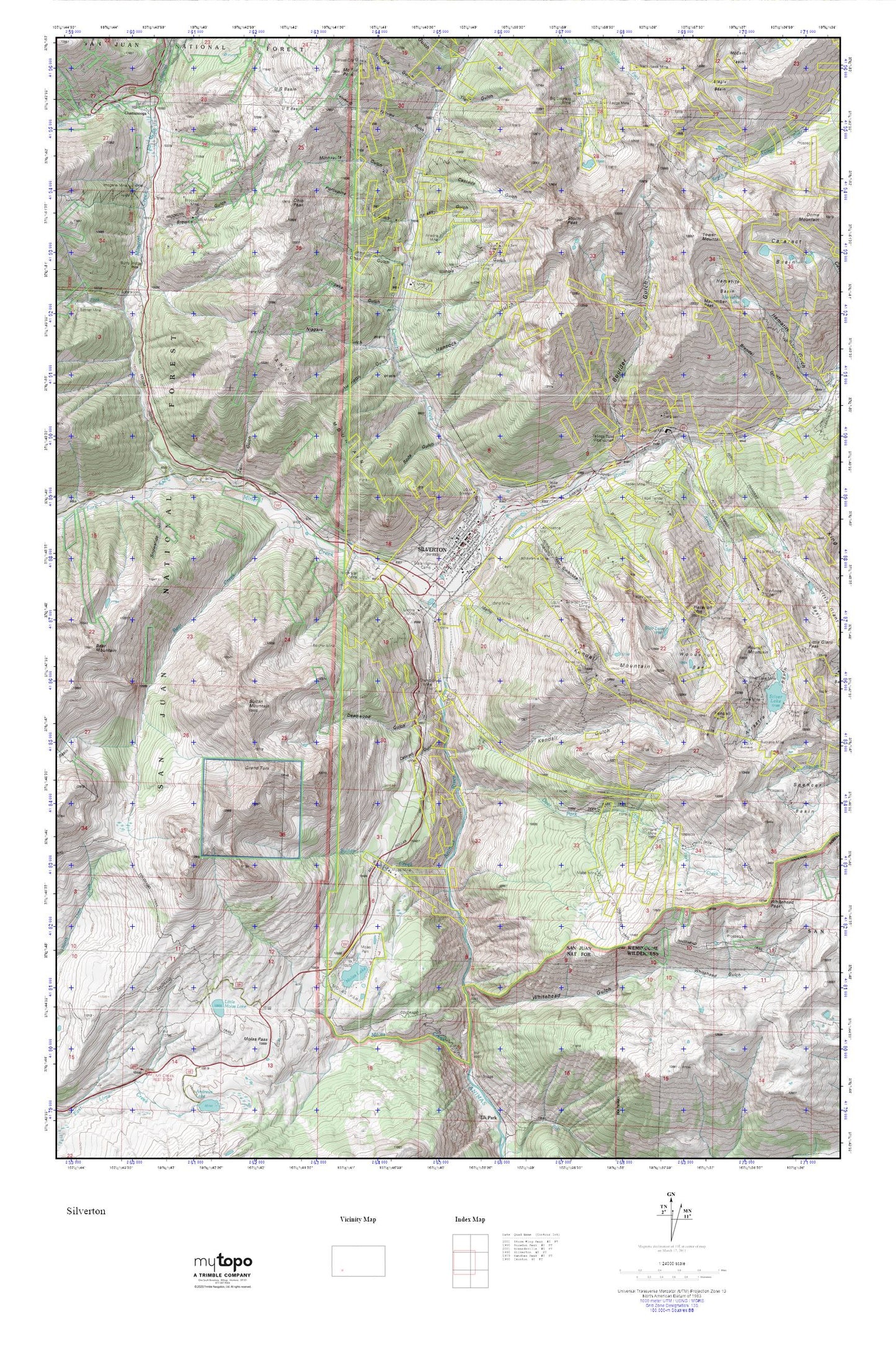
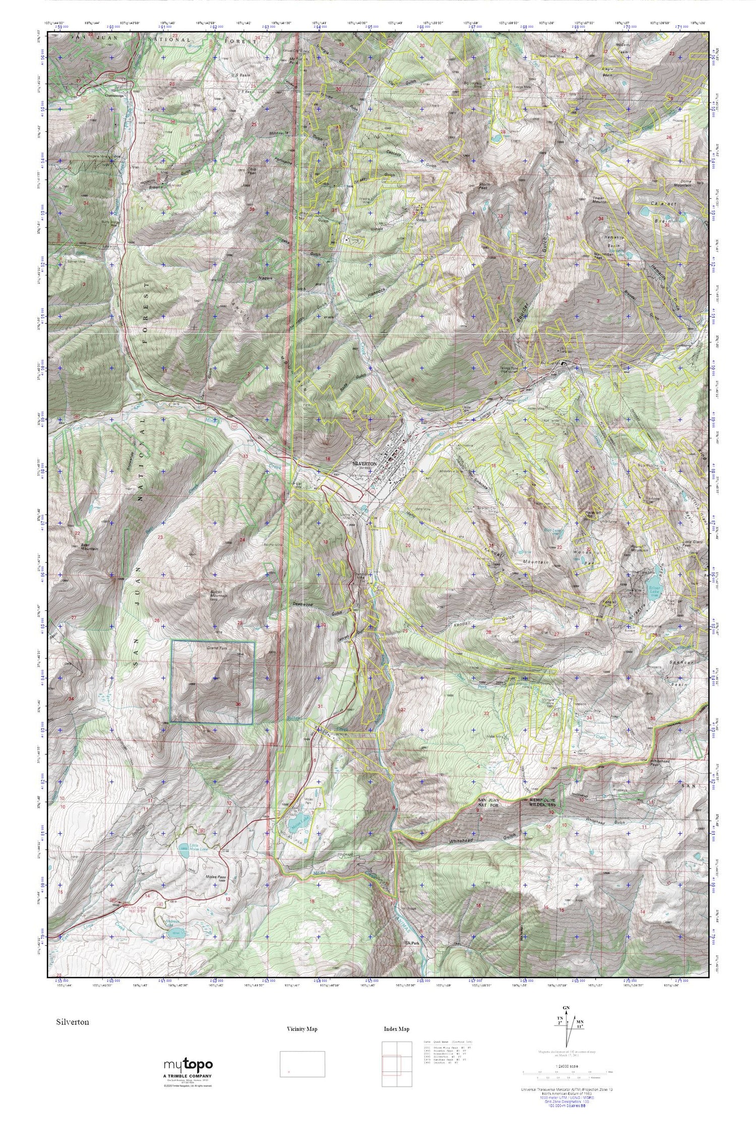
Topographic map of Silverton in the state of Colorado. From the MyTopo Explorer Series.
This topo map features shaded relief and comes with UTM / MGRS and Latitude/Longitude grids.
For more than two decades, MyTopo has provided maps to the most adventurous among us.. those who love to explore our nation’s remote wilderness areas, climb our highest peaks, and trek across our vast public lands. This map is part of a curated collection of the most popular places for which MyTopo customers have designed maps. It is a “bucket list” of the most amazing places to hike, hunt, and explore.
This map contains the following named places: Ajax Mine,Alethea Group Mine,Anglo-Saxon Mine,Anvil Mountain,Anvil Mountain South Mine,Ariedna Mine,Arrastra Basin,Arrastra Creek,Aspen Mine,Ayman Mine,Bear Creek,Belcher Mine,Ben Franklin Mine,Big Ben Claim,Big Colorado Mine,Big Giant Mine,Blair Gulch,Blair Lake,Blue Jay Mine,Boston Mine,Boulder Gulch,Brendel Gulch,Brooklyn Mine,Brooklyn Trail,Browns Gulch,Buckeye Mine,Burro Bridge,Cascade Gulch,Cataract Basin,Cataract Gulch,Cement Creek,Champion Mine,Chattanooga,Chattanooga Hot Spring,Chattanooga Mine,Clara Mine,Coming Wonder Mine,Crevice Mine,Dakota Mine,Deadwood Gulch,Deer Park Creek,Deer Park Trail,Dora Mine,Empire Group Mine,Fairview Gulch,Fairview Mine,Georgia Gulch,Gold Finch Group Mine,Gold Hub Mine,Gold Lake Mine,Graham Mine,Grand Turk,Grassy Gulch,Gypsy Claim,Hancock Gulch,Happy Jack Mine,Hawkeye Mine,Hazelton Mountain,Hematite Basin,Hematite Lake,Henrietta Gulch,Hidden Treasure Mine,Hillside Cemetery,Hoosier Boy Mine,Howardsville Mine,Idaho Gulch,Idaho Mine,Ideal Placer,Illinois Gulch,Imogene Mine,Iowa Mine,Irene Mine,Jennie Parker Mine,Kansas City Mine,KDRW-AM (Silverton),Kendall Group Mine,Kendall Gulch,Kendall Mountain,Kendall Peak,King Mine,KQZZ-FM (Silverton),KVFC-FM (Silverton),Lackawanna Mill,Lackawanna Mine,Lamont Mine,Legal Tender Mine,Liberty Bond Creek Mine,Little Dora Mine,Little Molas Lake,Lodore Mine,Lower Browns Gulch Mine,Mabel Mine,Macomber Peak,Marcella Mine,Maxwell Mine,Mayflower Mill,Mayflower Mine,McMillan Peak,Middle Fork Mineral Creek,Mighty Monarch Mine,Mill Creek,Million Dollar Tunnel Mine,Mineral Creek,Mineral Creek Mine,Minnesota Gulch,Minnesota Gulch Mine,Minnesota Mine,Molas Lake,Molas Mine,Molas Park,Molas Pass,Moly Gulch Mine,Montana Mine,Mount Rhoda,Mountain View Claims,Mystery Gold Group Mine,Natalie Mine,Niagara Gulch,North Star Mine,Ohio Gulch,Ohio Peak,Omaha Mine,Porcupine Gulch,Ricker Group Mine,Round Mountain,San Juan County,San Juan County Sheriff's Office,Saratoga Mine,Scranton City Mine,Senior Warden Mine,Silver Lake,Silver Lake Mine,Silver Ledge Mine,Silverheel Mine,Silverton,Silverton Division,Silverton Historic District,Silverton Junction Heliport,Silverton Post Office,Silverton San Juan County Ambulance Service,Silverton Volunteer Fire Department,Slagle Basin,Snowslide Gulch,Soda Gulch,South Fork Mineral Creek,Spencer Peak,Storm Peak,Sultan Creek,Sultan Mountain,Sunshine Mine,Swansea Gulch,Thunder Tunnel Mine,Tiger Gulch,Tincup Claim,Titusville Mine,Topeka Gulch,Tower Mountain,Town of Silverton,U S Basin,Unity Tunnel,Valley Forge Mine,Victoria Mine,Whitehead Gulch,Whitehead Peak,Whitehead Trail,Woodchuck Basin,Zuni Mine