MyTopo
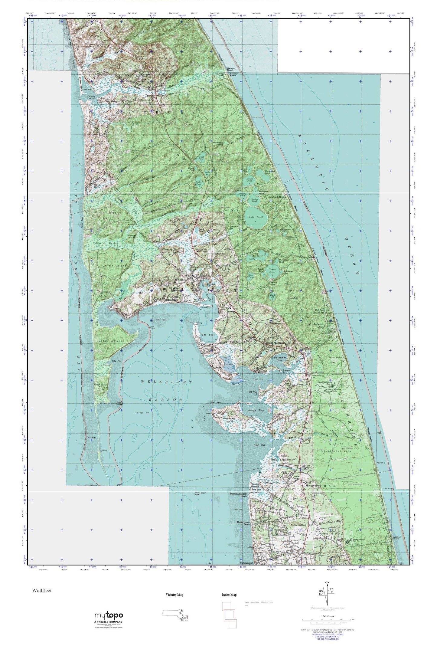
Wellfleet MyTopo Explorer Series Map
Couldn't load pickup availability
Topographic map of Wellfleet in the state of Massachusetts. From the MyTopo Explorer Series.
This topo map features shaded relief and comes with UTM / MGRS and Latitude/Longitude grids.
For more than two decades, MyTopo has provided maps to the most adventurous among us.. those who love to explore our nation’s remote wilderness areas, climb our highest peaks, and trek across our vast public lands. This map is part of a curated collection of the most popular places for which MyTopo customers have designed maps. It is a “bucket list” of the most amazing places to hike, hunt, and explore.
This map contains the following named places: 02651,02663,02666,02667,Audubon Bird Sanctuary,Ballston Beach,Bellingsgate Island,Blackfish Creek,Blackfish Creek Marshes,Bound Brook,Bound Brook Island,Brook Village,Brush Valley,Buoy Rocks,Cahoon Hollow,Cahoon Hollow Beach,Cahoon Hollow United States Life Saving Station,Camp Mar Vel,Camp Wellfleet Dunes,Cannon Hill,Cape Cod National Seashore,Cape Cod National Seashore Headquarters,Corn Hill,Drummer Cove,Duck Creek,Duck Harbor,Duck Harbor Beach,Duck Pond,Dyer Pond,Featherbed Swamp,First Church,First Congregational Church,Fisher Beach,Fox Bottom,Fresh Brook,Great Beach Hill,Great Hollow,Great Island,Great Island Trail,Great Pond,Griffin Island,Gross Hill,Gull Pond,Harbor Bar,Hatches Creek,Herring Pond,Herring River,Herring River Marshes,Higgins Pond,Hill of Churches Hills of Storms Cemetery,Horseleech Pond,Indian Neck,Indian Neck Marshes,Jeremy Point,Kinnacum Pond,Le Count Hollow,Lieutenant Island,Lieutenant Island Bar,Little Beach Hill,Little Pamet River,Little Pamet River Marshes,Loagy Bay,Loagy Bay Marshes,Lombard Hollow,Long Pond,Maguire Landing,Maguire Landing Beach,Marconi Beach,Marconi Station Site,Mayo Beach,Mayos Beach Light,Merrick Island,Mill Creek,Mill Pond,Nauset Regional School,Newcomb Hollow,Newcomb Hollow Beach,Northeast Pond,Oakdale Cemetery,Old Saw,Old Wharf Point,Pamet Cranberry Bog Trail,Pamet Harbor,Pamet Hollow,Pamet River,Pamet River Marshes,Pamet River United States Life Saving Station,Paradise Hollow,Perch Pond,Pine Grove Cemetery,Pleasant Hill Cemetery,Pleasant Point,Round Pond,Ryder Beach,Ryder Pond,Saint James Chuch,Shirttail Point,Silver Spring Brook,Silver Spring Brook Marshes,Silver Spring Harbor,Slough Pond,Smalley Bar,Smalls Hill,Snow Cemetery,Snow Pond,Snows Field,South Truro,South Wellfleet,South Wellfleet Cemetery,South Wellfleet Post Office,Southeast Pond,Spectacle Pond,Sunken Meadow,Sunken Meadow Beach,Sunken Meadows Marshes,The Cove,The Gut,Tom Hill,Town of Wellfleet,Truro,Truro Post Office,Truro Station,Truro Town Hall,Turtle Pond,Wellfleet,Wellfleet by the Sea,Wellfleet Drive-In,Wellfleet Fire Department,Wellfleet Harbor,Wellfleet Harbor Breakwater Light,Wellfleet Historical Society Museum,Wellfleet Police Department,Wellfleet Post Office,Wellfleet Town Hall,Wellfleet Town Pier,White Crest Beach,Williams Pond,Woods Beach Rock